
There was a time when the notion of having our own communications satellite was seen as controversial and nothing more than a vanity project. However, among academics and national telecommunications industry players, the project was seen as a strategic alternative for national telecommunications development.
The presence of Telkom satellites, also known as the Domestic Satellite Communications System (SKSD), is inseparable from the brilliant ideas of academics and national telecommunications industry players in the 1960s to boost the development and expansion of the national telecommunications system.
The idea to own and implement communications satellites was proposed by many academics, government experts and officials from Perumtel (as state-owned telco company PT Telkom was called back then) in various seminars, discussions, scientific speeches and other occasions.
Responses to the idea were not unanimously positive. Some disagreed with the plan simply because satellite technology was relatively new at the time. Besides, satellites were seen as too luxurious for Indonesia, which was still grappling with numerous economic problems. Only two countries operated communications satellites back then, namely the US and Canada. Therefore, many deemed the idea of Indonesia operating a satellite as being premature, especially as many doubted the government’s technical prowess to manage such modern technology.
The presence of the SKSD satellite system for an archipelagic nation like Indonesia means more than just strengthening the nation’s communications system. The SKSD system is also seen as a unifier for the diverse nation with its multitude of ethnicities, religions and local cultures. The system can also facilitate access to global information to boost the nation’s intelligence and act as the government’s information gateway to implement its archipelagic vision.
At the same time, state-owned satellites mean a better national defense and security system, especially to defend the nation’s territorial integrity, anticipate threats and disturbances and strengthen national’s unity.
Fortunately, the government of the time was not deterred by the numerous doubts being voiced. In early April 1974, the government officially announced the SKSD development plan in the mass media. Through news articles and opinion pieces in newspapers, the plan was promoted widely to everyone. Positive responses then came, both domestically and from abroad.

 The government followed up on the plan by collaborating with academics and satellite experts to obtain input for the development project. Support for the project was becoming stronger and culminated in the launch of Indonesia’s first satellite, Palapa A1. This satellite launch marked the beginning of Indonesia’s satellite era. (Photo credit: ieee.ca)
Up to 2015, Telkom had launched 10 satellites, namely Palapa A1, Palapa A2, Palapa B1, Palapa B2, Palapa B2P, Palapa B2R, Palapa B4, Telkom 1, Telkom 2 and Telkom 3.
From Palapa A1 to Telkom 3S
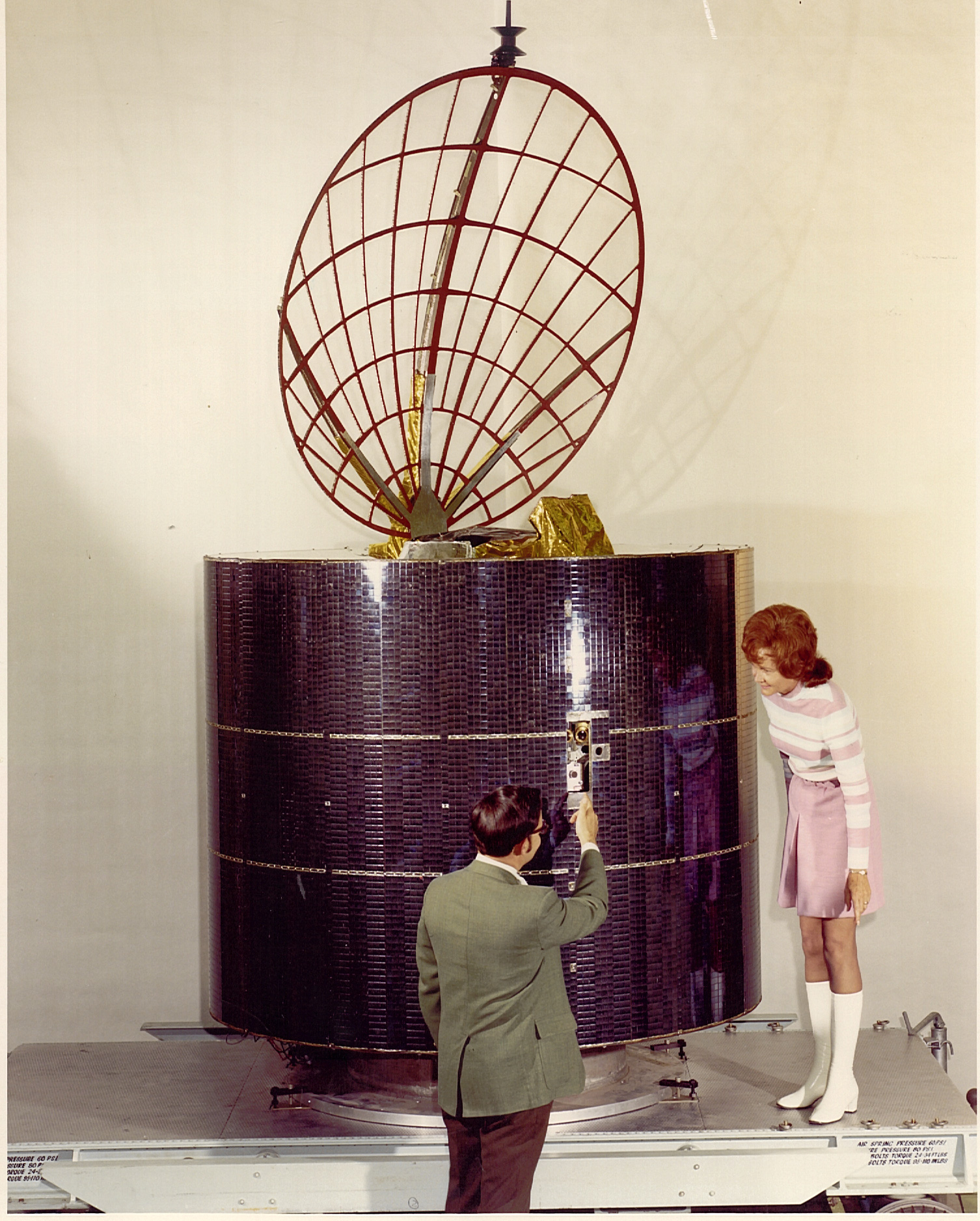
The moment of 6:31 a.m. Western Indonesian Time on July 8, 1976, or 7:31 p.m. local time in Florida, the US, was significant in Indonesia’s history. It was the time the Palapa A1 Indonesian communications satellite was launched from Kennedy Space Center in Cape Canaveral. The satellite was launched using a McDonnel Douglas Delta 2914 rocket and was put at a geostationary orbit of 83 degrees east. The satellite became fully functional on Aug. 16, 1976.
Next, the Palapa A2 satellite was launched on March 10, 1977 in Florida (March 11, 1977, at 6:16 a.m. Western Indonesian Time). It was launched using another McDonnel Douglas Delta 2914 rocket and was put at a geostationary orbit of 77 degrees east.
The Palapa A1 and Palapa A2 satellites had 12 active transponders that could each serve 400 telephone circuits, or 800 telephone channels, or one analog television channel signal. The A-generation Palapa satellites had a cylindrical shape, with a diameter of 2.16 meters and height of 2.84 meters. They had a design life of seven years. Palapa A1 reached the end of its design life in 1983 and Palapa A2 in 1984.
It was then decided that the satellites’ transponder capacities should be increased as, other than for domestic needs, a number of neighboring countries wanted to rent the capacity. The B-generation satellites were then designed with 24 active transponders and a longer life than the A-generation satellites. The B1, B2P and B2R satellites were designed to last eight years and the B4 satellite for 12 years.
The Palapa B1 satellite was a HS-376 satellite that was launched using the Columbia STS-7 space shuttle on its third commercial flight and seventh overall flight and was placed in a geostationary orbit of 108 degrees east on June 18, 1983, at 6:33 p.m. Western Indonesian Time.
The Palapa B2 launch on Feb. 26, 1984, using the STS-11S space shuttle, was a failure as the perigee motor did not operate properly and the shuttle became stuck at a low orbit (parking orbit) and could not reach the geostationary orbit. Perumtel then ordered the Palapa B2P satellite from the same company, namely Hughes Aircraft. The “P” on B2P means “pengganti” or “replacement”, signifying the satellite’s function to replace Palapa B2.
The B2P satellite was launched on March 21, 1987, at 6:18 a.m. Western Indonesian Time using a Deltra 6925 rocket from Cape Canaveral in Florida and was put at a geostationary orbit of 113 degrees east.
Meanwhile, after being adrift in orbit for eight months, Palapa B2 was returned home using the Discovery space shuttle. The satellite then became the property of a US-based insurance consortium.
To prepare the replacement for the B1 satellite, the Indonesian government then repurchased the B2 satellite and renamed it Palapa B2R, with the R meaning “recovery”. Palapa B2R was launched using a Delta II rocket on April 14, 1990, and was put at a geostationary orbit of 108 degrees east.
To replace the Palapa B1 satellite, which was nearing the end of its operational life orbiting at 118 degrees east, Telkom decided to purchase the Palapa B4 satellite, which was then launched using a Delta 7925 rocket from Cape Canaveral in Florida on May 14, 1992 (Indonesian time).
Afterwards, the era of satellites using the Telkom brand began. The Telkom 1 satellite was a successor of the B-generation Palapa satellites. After Telkom handed over the management of the C-generation Palapa satellites to PT Satelindo, it only operated two B-generation Palapa satellites, namely B2R and the B4. Both satellites had a total transponder capacity of 48.
The launch of the Telkom 1 satellite was intended to replace Palapa B2R, which was nearing the end of its operational life. The Telkom 1 satellite was then put in an orbital slot at 10 degrees east. The Telkom 1 satellite has 36 active transponders, comprising 24 standard C-band transponders and 12 extended C-band transponders. It was designed to last 15 years.
Afterwards, the Telkom 2 satellite was launched to replace Palapa B4. It was put in an orbital slot at 118 degrees east. The Telkom 2 satellite had the same transponder capacity as Palapa B4, namely 24 active transponders, all of which were standard C-band transponders. It was designed to last 15 years, the same as Telkom 1.
The Telkom 3S satellite
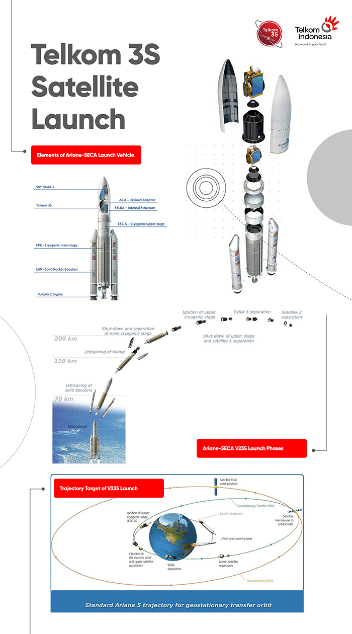
The Telkom 3S satellite is scheduled for launch on Feb. 15, 2017, at 4:39 a.m. Western Indonesian Time from the Guiana Space Center in Kourou, French Guiana. Instead of replacing previous satellites, this new satellite will add to existing transponder capacity.
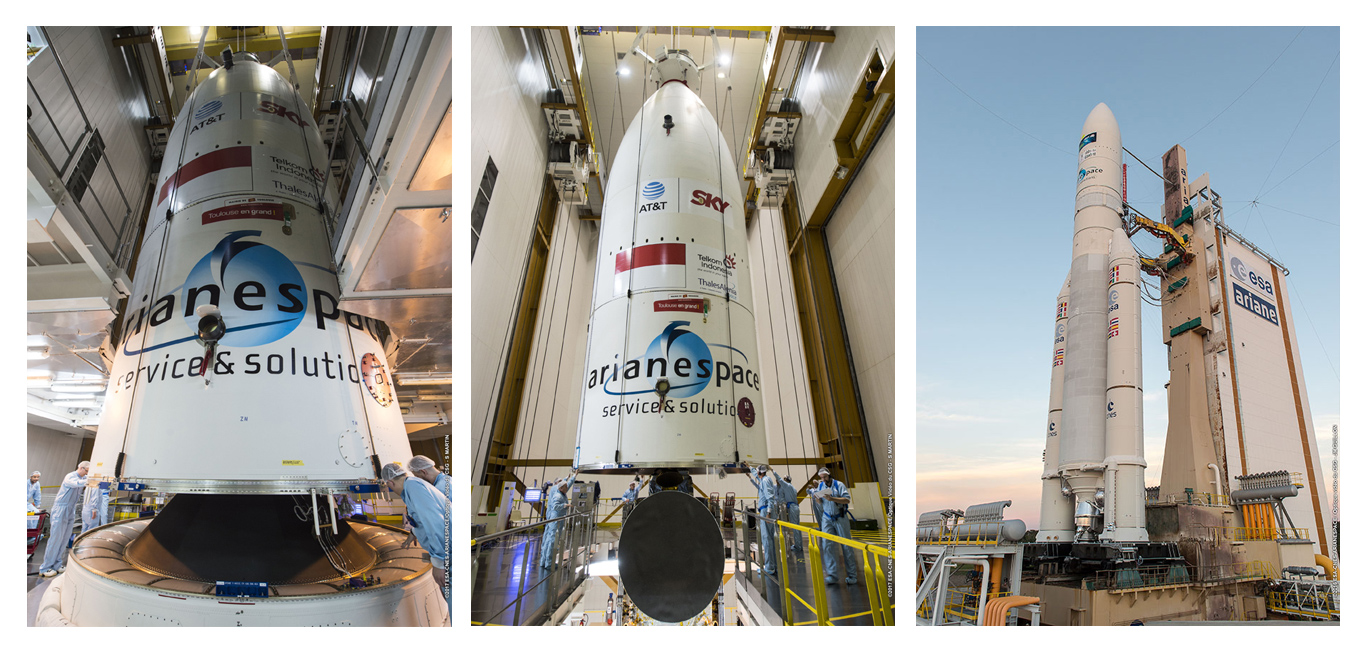 The plan is to launch the satellite using Arianespace Europe’s Ariane 5 ECA VA235 rocket. It will occupy an orbital slot at 118 degrees east, somewhere above the Makassar Strait. In this position, the Telkom 3S satellite will be able to encompass the entire Indonesian territory, as well as Southeast Asia and parts of East Asia.
The Telkom 3S satellite is designed to fulfill the increasing demand for transmission equipment in the development of Indonesia’s satellite business services, considering the nation’s need for a satellite as a backbone that is not fiber optic. Another consideration is Indonesia’s unique geographical characteristic, comprising thousands of islands and hard-to-reach mountainous regions that terrestrial and fiber-optic communications networks cannot satisfy. Therefore, a satellite-based communications system is the right solution due to its ability to reach the frontiers, outermost and remote regions. Thus, there are expectations that the telecommunications and informatics gaps in numerous regions in Indonesia can be overcome.
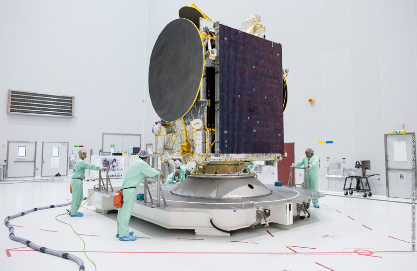
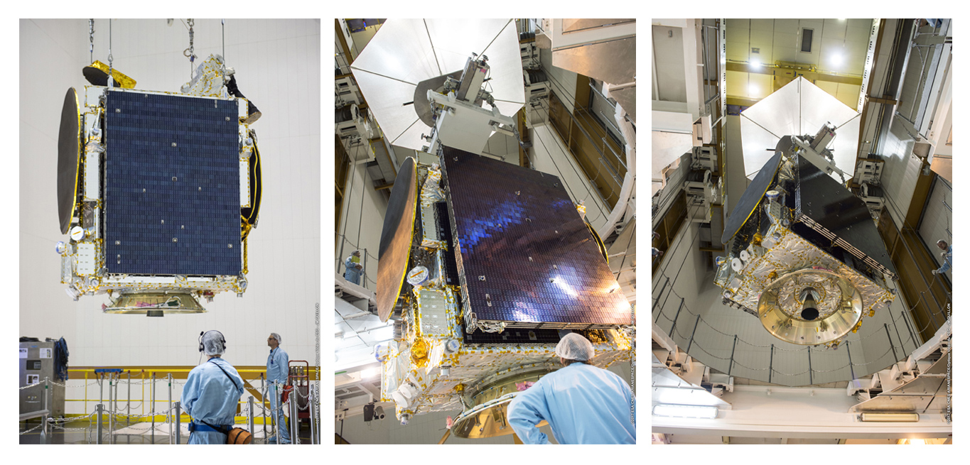 The Telkom 3S satellite has a total transponder capacity of 42, comprising 24 C-band transponders (24 TPE), eight extended C-band transponders (12 TPE) and 10 Ku-band transponders (13 TPE), a type that was not served by previous Telkom satellites (Photo credit: Arianespace)
The advantage of a Ku-band transponder is its ability to provide higher bit-rate services, thus resulting in better communications quality for high-definition television broadcasts, cellular communication services and broadband internet.
The presence of the Telkom 3S satellite is expected to boost the government’s Nawacita program (nine-point programs), especially the first point, which is protecting the people through national defense and security development and strengthening the nation’s identity as a maritime power. Beyond that, the satellite is expected to assist the government in realizing Nawacita’s third point of developing Indonesia’s frontier regions and strengthening the nation’s regions in the framework of a unitary state.
Telkom 3S Satellite
The Telkom 3S Satellite is a geostationary communications satellite owned by Telkom Indonesia. This satellite is placed above the equator and encircles the Earth in a circular path that has a rotation axis similar to that of the Earth.
- Background
- Satellite communications systems complement terresterial systems and can cover the frontier, outermost and most remote regions.
- The annual increase in the domestic and regional need for transponders requires an additional number of transponders to fulfill the service.
- Parallel with the development of technology, which requires better quality satellite communications system.
- The Use of Satellites
- Two-thirds of regions in Indonesia have yet to be covered by terrestrial communications systems. Satellites and terresterial technologies form a complementary network, in which satellites fulfill the infrastructure need of regions that have yet to be covered by teresterrial networks, thus erasing the information access gap.
- Satellites will play a significant role in implementing the government’s Nawacita (nine strategic goals), especially its first point of protecting the people through national defense and security development and to strengthen the nation’s identity as a maritime power, and its third point to develop Indonesia at its frontier regions and strengthen the nation’s regions in the framework of a unitary state.
- Able to fulfill the need for high-definition television services, cellular communications, broadband internet, VSAT communications system that can cover regions across Indonesia, Southeast Asia and some regions in East Asia.
- Telkom 3S Satellite Specifications:
- Production by: French-owned Thales Alenia Space (TAS)
- Type: Geostationary communications satellite
- Transponder capacity: 42 transponders comprising 24 C-band transponders, 8 C-band extended transponders and 10 Ku-band transponders.
- The Launch of the Telkom 3S Satellite:
- Date: Feb. 15, 2017.
- Time: 4:39 a.m. (Indonesian Western Time).
- Location: Guiana Space Center, Kourou, Guiana, France.>
- Rocket launcher: Ariane 5 ECA VA235, owned by satellite company Arianespace Europe
- Orbit: 118° east, or above Kalimantan.
- Operation term: 15 years from after the satellite is launched.
- The Advantages of the Telkom 3S satellite
- Provides services at a higher bit-rate, thus resulting in better communications quality
- Provides quality high-definition television broadcasts, cellular communications services and broadband internet that can cover regions across Indonesia, Southeast Asia and some regions in East Asia.
- Provides services at a higher bit-rate, thus resulting in better communications quality
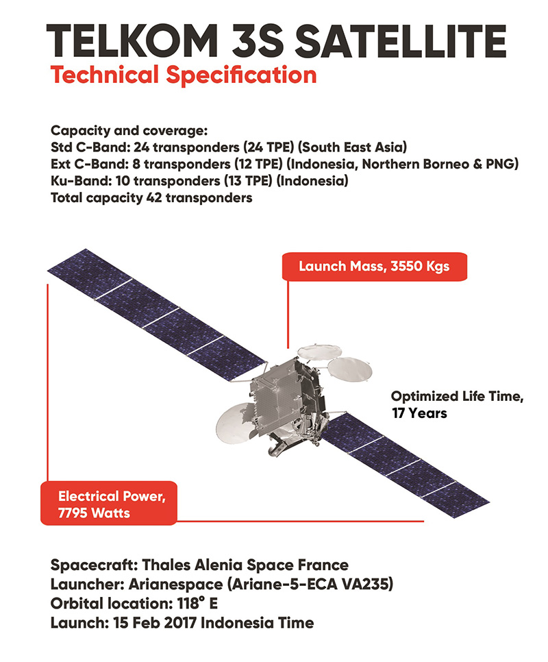
Telkom 3S Satellite weighs 3.5 tons or 1.527 kilograms of max dry mass and will be put at an orbital slot of 118 degree east. Its position will be above Kalimantan. For Indonesia, it will be an ideal position because it is in the center of the archipelagic country. The advantage of the position is that the entire bandwidth that the Telkom 3S Satellite will be able to provide optimal and equal service to regions across the country. Telkom 3S Satellite will have a 15-years term of operation.
Telkom 3S Satellite was produced with a total capacity of 42 transponders, comprising 24 C-Band transponders (Southeast Asia), 8 C-Band extended transponders (Indonesia, North Kalimantan and Papua New Guinea) and 10 Ku-Band transponders (Indonesia).
One of the advantages of Telkom 3S is that with the Ku-Band transponder, it will be able to provide service at a higher bit-rate, as well as provide a better quality of communication, high-quality television broadcast (High-Definition Television), cellular communication service and broadband internet.
The presence of Telkom 3S Satellite will add to the number of satellite transponders for domestic service, which is expected to minimize Indonesia’s reliance on foreign countries in terms of fulfilling satellite needs.
Indonesia as an archipelagic country has been in dire need of such a satellite system, which will allow for easy communication access, especially to the frontier, the outermost and the most remote regions.
Arianespace has successfully launched two satellites: SKY Brasil-1 for AT&T/DIRECTV; and Telkom 3S for Telkom Indonesia as part of a turnkey contract with Thales Alenia Space. (source: Arianespace)
This article brought to you by:
![]()