TheJakartaPost
Please Update your browser
Your browser is out of date, and may not be compatible with our website. A list of the most popular web browsers can be found below.
Just click on the icons to get to the download page.

Popular Reads
Top Results
No results found. Please check your search term and try again
Can't find what you're looking for?
View all search resultsPopular Reads
Top Results
No results found. Please check your search term and try again
Can't find what you're looking for?
View all search results4,300 evacuated as eruptions worsen
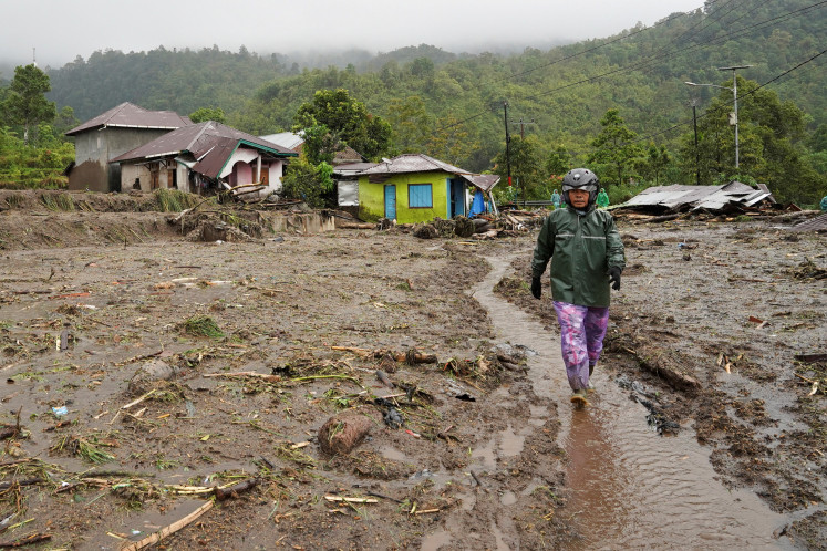
Volcanic repercussions: A soldier and a police officer move a sick resident from Gurukinayan, a hamlet affected by the volcanic eruptions of Mount Sinabung in Karo regency, North Sumatra
Change text size
Gift Premium Articles
to Anyone
Share the best of The Jakarta Post with friends, family, or colleagues. As a subscriber, you can gift 3 to 5 articles each month that anyone can read—no subscription needed!

V
span class="caption">Volcanic repercussions: A soldier and a police officer move a sick resident from Gurukinayan, a hamlet affected by the volcanic eruptions of Mount Sinabung in Karo regency, North Sumatra. The volcano spewed hot ash 4,000 meters into the air on Monday, sparking panic among residents who had not evacuated in the first days of the eruptions. Antara/Septianda Perdana
As many as 4,300 residents in five villages in Karo regency, North Sumatra, were evacuated following increasing threats of volcanic ash, pyroclastic flows and molten lava, caused by Mount Sinabung's strong eruptions on Monday.
The recent evacuation was carried out on Monday when a joint team comprising personnel from the police, the Indonesian Military (TNI), and the local administration evacuated 2,500 residents in Gurukinayan village.
Karo regency administration spokesman Jhonson Tarigan said residents in Gurukinayan were evacuated because the village, located around 4 kilometers from the volcano, was already covered in volcanic ash.
Jhonson added that the government refused to risk allowing residents to remain in their homes as volcanic ash emitted by the volcano had reached the village.
'Mount Sinabung again erupted strongly [on Monday] and discharged volcanic ash, pyroclastic flows and molten lava. The eruption threatened residents living in Gurukinayan, so we have evacuated them,' Jhonson told The Jakarta Post.
He said the volcano erupted twice on Monday morning, the first at 6:14 a.m. and the second at 7 a.m. He added the first eruption was more powerful, spewing volcanic ash as high as 4,000 meters, followed by pyroclastic clouds
and molten lava that flowed down the slopes of the mountain between 500 and 1,000 meters from the crater.
Jhonson said during the first eruption, volcanic ash reached Gurukinayan village and caused panic among residents. The village, he added, was not included in the danger zone as it is located beyond the 3-kilometer radius.
Jhonson said residents from five villages had been evacuated following the first eruption two weeks ago. Four of the five villages are located within the 3-kilometer radius. They are Simacem, Bekerah, Suka Meriah and Mardinding, while Gurukinayan is located outside the 3-kilometer danger zone.
'We have evacuated 4,300 people from the five villages,' said Jhonson, adding the evacuees were accommodated in a number of shelters in Kabanjahe, Tiga Nderket, Paung and Namanteran districts.
Disaster Response commander Let. Col. Meyer Putong, who is also Tanah Karo Military Command chief, said the evacuees' were in good condition. He added they were not allowed to return home until conditions improved.
'Mount Sinabung erupts almost every day, so conditions aren't safe for evacuees to return home,' Putong said, adding the emergency response status was still imposed.
The Karo regency administration has declared an emergency response period following the increasing frequency of Mount Sinabung's eruptions since Nov. 5.
The imposition of the emergency response period has forced evacuees, who are mainly farmers, to suffer losses. Their farms can no longer be tilled as they are covered by thick ash.
North Sumatra Agriculture Office head M. Roem said farmers suffered losses of more than Rp 4 billion (US$345,930) due to the eruptions.
'As many as 4,467 hectares of unattended farmland in Payung, Tiga Nderket and Namanteran districts are affected by the eruptions,' said Roem.
He added that besides the 4,467 hectares of unattended farmland covered by volcanic ash, 3,440 hectares were also impacted by the eruptions, but they could still be cultivated by residents.
The eruptions have also disrupted the supply of food commodities, in particular vegetables, from North Sumatra to several other areas in Sumatra, including Batam in Riau Islands.
Karo is widely known for its agricultural products, such as potatoes and oranges, which are marketed to Jakarta and cities across Sumatra.