TheJakartaPost
Please Update your browser
Your browser is out of date, and may not be compatible with our website. A list of the most popular web browsers can be found below.
Just click on the icons to get to the download page.

Popular Reads
Top Results
No results found. Please check your search term and try again
Can't find what you're looking for?
View all search resultsPopular Reads
Top Results
No results found. Please check your search term and try again
Can't find what you're looking for?
View all search resultsCruising Indonesian waters: Read nature, notice differences
Change text size
Gift Premium Articles
to Anyone
Share the best of The Jakarta Post with friends, family, or colleagues. As a subscriber, you can gift 3 to 5 articles each month that anyone can read—no subscription needed!
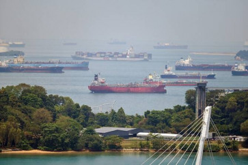
 There is truly no greater cruising ground than Indonesia, an archipelago of over 17,000 islands. (Shutterstock/-)
H
aving explored Indonesian waters for a decade, Andrew Scott recently shared his knowledge in the book Cruising Guide to Indonesia: A pilot guide to Indonesian waters.
Currently residing in Bali, Scott is a US Coast Guard licensed captain who works on private as well as chartered sailing vessels, both Indonesian and foreign-flagged, across the country.
As an experienced sailor on Indonesian waters, he said he was often asked for tips by fellow sailors, and thought he would share his knowledge with a wider audience.
“I never intended to write a book. I was sailing on a private sailboat and just taking all these notes for myself and the safety of the ship. Nautical charts and Electronic C-maps in Indonesia can be very inaccurate with large data offsets.”
The maps included in the book are from his personal collection, which he gathered over the years for his own guidance while sailing.
(Read also: Full-size replica of Titanic to sail in 2018)
“Sometimes whole reefs, rocks and islands are completely missing from the charts. Obviously these are huge navigational hazards and curiously I would jot them down. After a couple of years, I realized I had written a book. Most countries already have a cruising guide and with Indonesia lacking, I just filled the space. But I should point out that there are some modern Indonesian charts made by the government that are very good.”
Scott compiled maps from Aceh to Papua, and added extensive material to provide what navigators need to safely sail around Indonesia. In his book, sailors can find comprehensive and detailed information to guide them to safe places to anchor, as well as data about the depth of water, dangerous reefs, cellphone signals and activities for boat passengers in surrounding areas.
 Andrew Scott's book Cruising Guide to Indonesia: A pilot guide to Indonesian waters has reportedly become a must-have handbook for every captain sailing in Indonesian waters.(-/-)
Though most modern boats and yachts are equipped with contemporary maps, Scott said his book provided important information that was not available on maps and was essential to avoid chart errors.
“There were a number of yachts that ran aground in 2015 in the Anambas Islands. They were sailing through an area that, according to the charts, was clear of danger. They had the latest in marine electronic charts onboard and all of the boats ran aground one after another,” Scott told The Jakarta Post via email.
(Read also: Thousands of foreign cruise passengers arrive in Semarang)
But even extensive information and complete charts of surrounding landscapes with the latest technology are not enough. Scott said every sailor must have the ability to read nature as well.
“I think most of the work is done before you leave the dock. Knowing the state of the wind, tide, currents and what to expect ahead of time. In my mind, I call it predicting the future,” he said.
“At the immediate level, you would be looking for anything different; if the water is sheet glass and you see a roughed up bit that looks different. Another day it could be just the opposite with rough seas everywhere and a smooth patch of water ahead. Notice the differences.”
Scott's self-published book, which received salutations from reputable sailors including Jimmy Cornell, author of World Cruising Routes and Cornell’s Ocean Atlas and founder of the ARC sailing rally, has reportedly become a must-have handbook for every captain sailing in Indonesian waters.
At the moment he is preparing a second edition that will feature islands like Anambas, Natuna, Kai, Tanimbar and Triton Bay.
“The [new] book probably has somewhere around 400 maps and anchorages and will be available in early 2017," he said. (kes)