

The 7.4-magnitude earthquake that wrought devastation in Central Sulawesi on Sept. 28 was a scientific prophecy that came true. Armed with evidence of similar catastrophes in the area more than a century ago, scientists had warned of a potential tectonic calamity years before the monstrous quake struck, triggering a tsunami and land liquefaction.
By: Safrin La Batu & Kharishar Kahfi / The Jakarta Post
The danger they referred to is the 500-kilometer fault line bisecting Sulawesi from the Palu Bay in the north to the Bone Bay in the south. It is the second-longest after the Sumatran fault line, which spans 1,900 km. History shows that the seemingly dormant monster violently shakes the Earth every 130 years or so. The next-to-latest disaster occurred in 1909. Then, according to Dutch scientists, a 7.0-magnitude earthquake destroyed Central Sulawesi villages.
Due to the confluence of three major tectonic plates, the Indo- Australia, Pacific and Eurasia, Sulawesi is known to have many active faults. The Center for National Quake Studies noted that the number of faults jumped to 48 last year from just 12 in 2010.
But characteristically, the repeated warnings and calls for serious mitigations in Central Sulawesi had fallen on deaf ears. And this ignorance irks Trinirmalaningrum, a geologist who led an expedition team that tracked the Palu-Koro fault just a few weeks before the earthquake hit Palu and Donggala.
“In the streets of Palu, posters of political candidates are ubiquitous, but ones providing informa-tion on the danger of earthquakes are rare,” she says.
Trinirmalaningrum recalls how Central Sulawesi’s provincial government bureaucrats, including Central Sulawesi Governor Longki Djonggala, downplayed her studies on the Palu-Koro fault line and her recommendations on mitigatory measures. She expected some appreciation for her team’s efforts but instead, they were regarded as “scaremongers”.
The governor fumed and expressed fear that news about the geologists’ findings could cause anxiety among locals, force them to sell their property and move to other areas they think are less prone to natural disasters.
“The governor asked us to refrain from making our findings public,” she says. “They [local officials] only wanted to hear people tell them rosy stories about Donggala and Palu. The truth is that the Palu-Koro fault keeps moving, threatening to unleash its destructive energy.”
Like countless other places across the country, Palu is an example of a town that has been built without taking proven dangers of natural disasters into consideration. This is probably because no one survived the 1909 quake to tell their account.
With a population of about 335,000, Palu faces open seas without safety walls to protect its coastlines from high waves. Huts, restaurants, shops and all sorts of buildings stand on the touristy sandy beaches of Talise. When the tsunami struck at dusk of Sept. 28, the area was bustling with fun seekers, many of whom drowned.
“If local authorities had been aware of the dangers, they should have left the Talise beaches un-occupied at all times. Now, they must learn the lesson [the hard way],” Trinirmalaningrum says.
There are no contingency plans or evacuation drills made in anticipation of emergency situations. But make no mistake. Such negligence is by no means typical to Palu. It also plagues the national level as the Supreme Audit Agency (BPK) has found.
In 2017, BPK auditors scratched their heads upon discovering that the disaster maps made by the Volcanology and Geological Hazard Mitigation Center (PVMBG) was wildly inaccurate. The maps were so lacking in detail that they could not be used to support mitigation programs. The BPK even called them “useless”.
Bad data
The BPK found that most of the PVMBG’s maps had scales ranging from 1:250,000 to 1:100,000, a far cry from the ideal 1:10,000. It said the maps could hardly be used even for the purposes of tourism, which did not require a high level of accuracy to locate a place of interest.
In the maps, disaster-prone areas are marked in red, but many are smudged so that they extend beyond the actual designated areas.
The audit also found that the PVMBG did not communicate effectively with local administrations, resulting in the poor dissemination of maps and other works. This, too, has had domino effect as the poor mapping feeds regional administrations bad data they would use for spatial planning.
Under Law No. 26/2007 on zonation, regional administrations are required to take potential natural disasters and geological conditions, among other parameters, into consideration when making spatial planning. Then the draft will be checked by the Agrarian and Spatial Planning Ministry be-fore being passed as a bylaw.
The Spatial Planning Law gives regional administrations the authority to design their own spatial plans but requires them to follow guidelines provided by the central government. It also requires the central government to supervise regional administrations’ zoning policy.
The legislative process sounds all good, but in reality, not all regional administrations follow the procedure properly, as the director general for spatial planning, Abdul Kamarzuki, concedes. What’s more, the law prescribes no penalty for heads of regional governments who do not abide by it. So, some regions have yet to do spatial planning. Others have it but they disregard the geological agency’s guideline.
Palu passed its spatial planning ordinance in 2011, complete with a potential earthquake and tsu-nami mapping. Liquefaction — a natural process that occurs when the ground loses its firmness as heavy soil and rock sink while light soil and sand rise to the surface — was added to the list of fac-tors by the geological agency only in 2012. That is why Palu allowed building in liquefaction-prone areas like Balaroa and Petobo in its 2011 spatial plans.
More than 5,000 people went missing in September’s earthquake in both districts, along with their homes that appeared to have been swallowed by the Earth.
The fact that only a handful of regions have detailed spatial planning has raised concern even among central government officials. The Agrarian and Spatial Planning Ministry has called on regional administrations to draft their bylaws soon.
Compromise
Understanding that it may take local administrations years to revise bylaws to include detailed in-formation about disaster-prone areas, local and central governments struck a compromise: Until they have detailed spatial plans approved by the ministry, regions may draw their maps on disaster-prone areas as a base for their development plan.
This looks like a feasible interim solution, given that it would take the PVMBG years to prepare detailed maps for each of the more than 500 regencies and mayoralties. Between 2015 and 2017, the government conducted studies on 19 disaster-prone areas, including with potential tsunamis, in Kulon Progo in Yogyakarta, and Pariaman and Padang Pariaman in West Sumatra.
A potential tsunami from the Indian Ocean in Kulon Progo has been under international scrutiny as it is about to begin construction of a seaside international airport. The west coast of Sumatra has been identified as one of the most tsunami-prone areas in the world. In 2009, a 7.6-magnitude earthquake and subsequent tsunami hit the area, killing more than 1,100 people.
This year, studies have been taking place in nine regions, including Palu. The results are expected to be made public by the end of the year.
In the latest effort to bolster disaster mitigation, the National Development Planning Ministry (Bappenas) has been tasked with design a national master plan — a policy expected to deliver a massive makeover in the way Indonesia deals with disasters.
Bappenas is joining hands with the Japan International Cooperation Agency (JICA), hoping that Indonesia can learn about disaster management from Japan, which, like Indonesia, is vulnerable to earthquakes and tsunamis, and sits on the ring of fire. Experts from both countries have visited Palu to measure the scale of devastation and map the affected areas.
While their short-term focus is reconstruction in Central Sulawesi, their long-term goal is to study the vulnerability levels throughout Indonesia. The outcome will be used as a reference for national spatial planning. Recommendations may include the relocation of people from earthquake and tsunami-prone areas like Palu, National Development Planning Minister Bambang Brodjonegoro says. The earthquake and tsunami in Palu and Donggala, which killed more than 2,000 people and left thousands of families homeless, underlined the need for local administrations to take potential disasters more seriously.
Now, Central Sulawesi’s governor has a terrifying, firsthand story to tell.
In Indonesia, fault lines
are ticking time bombs
By: Kharishar Kahfi / The Jakarta Post
The chance to escape is probably slim when, or if, a big earthquake happens. But let’s live with this reality: Those giant tectonic plates are highly active underneath Indonesia. We may take earthquakes for granted while scientists warn monstrous ones may be yet to come.
That is a risk that comes with living in a country located on the Pacific “ring of fire”. Indonesia lies on top of two major tectonic plates — the Eurasia and Indo-Australian plates — as well as several minor ones. The country is also surrounded by the Pacific and Philippine Sea oceanic plates.
An earthquake occurs whenever these plates hit each other, or the immense energy accumulated from years of contact between two plates is released.
Indonesia has recorded numerous massive earthquakes and resulting tsunamis over the past few centuries. In 1699, a big earthquake destroyed much of what is now Jakarta. In 2004, the well-documented natural catastrophe in the Indian Ocean left 170,000 dead in Aceh. Just two months ago, on Sept. 28, a 7.0-magnitude earthquake and tsunami struck Central Sulawesi, leaving more than 2,000 people dead and a massive trail of destruction. That happened only two months after a 6.4-magnitude quake wrought devastation in Lombok, West Nusa Tenggara, which claimed more than 500 lives and left thousands of families homeless.
The latest string of earthquakes sent a chill on other islands. Scientists warn of similar disasters in Java, where about 150 million people live, or close to 70 percent of Indonesia’s population. On this island, the latest major earthquake struck the West Java regencies of Tasikmalaya and Cianjur, where the death toll reached 87 in 2009.
In Java, and probably parts of Sumatra, it is believed that the biggest threat will come from the Sunda megathrust located deep beneath the sea, around 150 kilometers south of Java. It is where the edges of two tectonic plates converge.
Earthquakes can happen in megathrust zones when one plate forces the other underneath in a process called subduction. The subduction zone between the Eurasian and Indo-Australian plates is called the Sunda megathrust, which stretches in the Indian Ocean from Sumatra west to Java south.
While most megathrust earthquakes are small with a moment magnitude scale (M) under 5, the effect can be immense. Experts say that the 2004 quake triggering deadly tsunamis in Aceh and several other countries by the Indian Ocean was a megathrust that happened when part of the Indo-Australian plate was subducted by the Eurasian plate.
It is feared that a similar disaster may occur in Java if the Sunda megathrust releases energy to the surface big enough to trigger a tsunami.
However, scientists have discovered that several smaller tectonic faults are also able to trigger large-scale earthquakes in the island’s west coast.
The most well-known might be the Lembang fault in West Java which, scientists say, moves at a speed of 3 millimeters a year, a bit slower than the Palu- Koro fault in Sulawesi that triggered the September earthquake.
While it does not pass under the West Java provincial capital of Bandung, a large earthquake triggered by the Lembang fault is predicted to still cause massive destruction.
Then, there is also the Baribis fault, stretching from East to West Java. It is believed to have caused a 7-plus-magnitude earthquake in Jakarta in 1780.
“Unfortunately, we know very little about this fault, especially its precise location in western Java — whether it passes under Bogor, Jakarta or in between,” says Sukmandaru Prihatmoko, chairman of the Indonesian Geologists Association (IAGI).
Despite the well-known potential dangers from earthquakes, geological information that Indonesia needs for mitigation purposes, especially in major cities like Bandung and Jakarta, is far from adequate.
Ironically, public information drives sometimes hit a snag largely because of a lack of understanding among laypeople and authorities alike about how science works. The best-known case in point occurred in April when Widjo Kongko, a scientist from the Agency for the Assessment and Application of the Technology (BPPT), was summoned by the police on suspicion of spreading false information after he made public his study about the Sunda megathrust.
His most earth-shaking revelation during a seminar on potential big quakes in Java was that a 9.0-magnitude Sunda megathrust could unleash a tsunami as tall as 57 meters and could sweep through western Java down to its northern coasts, including Jakarta.
The findings sparked a heated debate in the local media. The Meteorology, Climatology and Geophysics Agency (BMKG) was among those skeptical about his theory and police believed it was dangerous. Widjo eventually escaped scrutiny after civil groups and fellow academics came to his defense.
The Central Sulawesi disaster has been a wake-up call for the need for information on potential major earthquakes in the future. The National Disaster Mitigation Agency (BNPB) has issued a disaster mitigation handbook on safety measures.
“We need to educate people on disaster mitigation because their awareness [on the issue] is poor,” says BNPB spokesman Sutopo Purwo Nugroho.
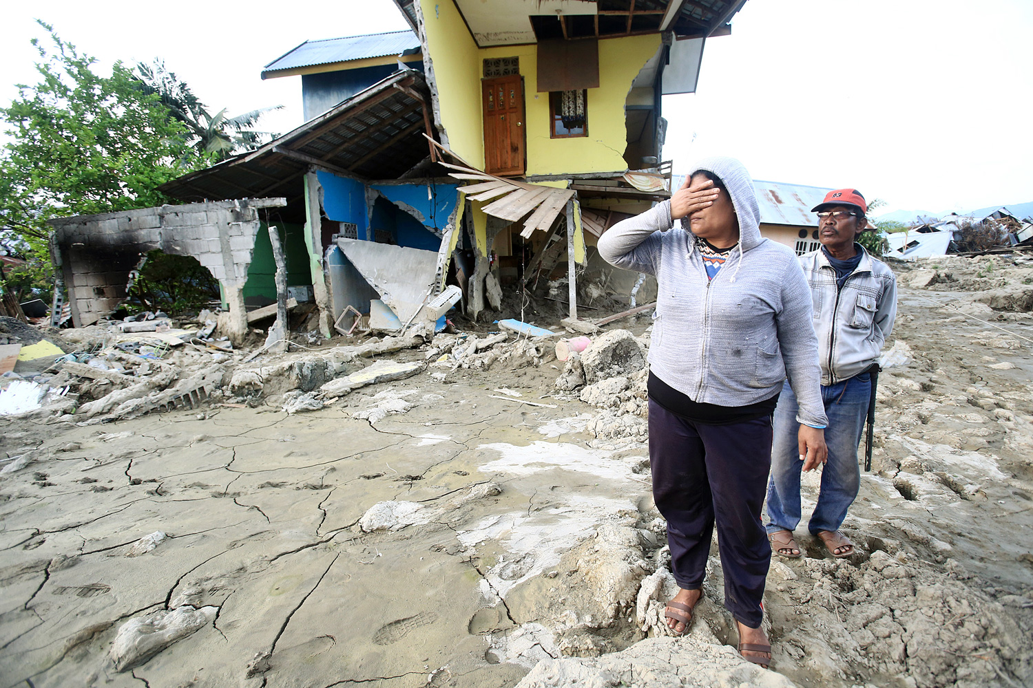 Sinking feeling: Residents search for their home in the Petobo are of Palu, Central Sulawesi, where entire hamlets were swallowed
by the Earth or carried away by streams of sludge that surfaced after an earthquake triggered soil liquefaction.(JP/Dhoni Setiawan)
| Writers | : | Safrin La Batu, Kharishar Kahfi |
| Photographers | : | Seto Wardhana, Dhoni Setiawan |
| Managing Editor | : | Primastuti Handayani |
| Desk Editors | : | Pandaya, Imanuddin Razak |
| Art & Graphic Design Head | : | Budhi Button |
| Technology | : | Mustopa, Sandy Riady Hasan, Adri Putranto |
| Multimedia | : | Bayu Widhiatmoko |