TheJakartaPost
Please Update your browser
Your browser is out of date, and may not be compatible with our website. A list of the most popular web browsers can be found below.
Just click on the icons to get to the download page.

Evacuation volunteers rely on radios for safety
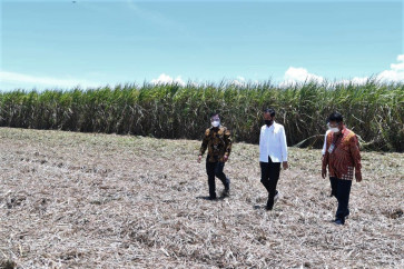
Danger zone: Members of a joint evacuation team consisting of military and public officers and volunteers on Thursday inspect what was a hamlet wiped out by pyroclastic flows from Mount Merapi’s Nov
Change Size

D
span class="inline inline-left">Danger zone: Members of a joint evacuation team consisting of military and public officers and volunteers on Thursday inspect what was a hamlet wiped out by pyroclastic flows from Mount Merapi’s Nov. 5 eruption, the biggest since it began exploding on Oct. 26. JP/Slamet Susanto The handheld radio transceiver is a vital instrument for volunteers evacuating victims from erupting Mount Merapi as they anticipate hot clouds that unpredictably spew from the world’s most active volcano.
When hot clouds (pyroclastic flow) spew, the evacuation teams’ radio units sound an alarm. The sound is relayed from the seismographs section at the Volcanic Technology Development and Research Center (BPPTK) Yogyakarta.
“If we use cellular phones to alert our team of pyroclastic flows, the flow will reach us before the SMS,” said Hamid Tolchah, 30, an evacuation team member from the Yogyakarta Red Cross (PMI) on Thursday.
With handheld radios, he said, volunteers could stay tuned to one channel and receive vital information simultaneously.
“When it sounds an alarm, everyone knows what to do: Run!” Hamid, who has been a PMI member for about a year, said.
Before the danger zone was expanded to a 20-kilometer radius from the crater of Merapi, following the biggest eruption in recorded history on Nov. 5, Hamid was tasked with distributing clean water to refugees within the previous 10-kilometer danger zone.
He said this time was valuable as an evacuation team member because he was familiar with the geography of fields that later became danger zones.
Such solid knowledge on the “red zones” is a requirement for evacuation team members.
Thursday’s evacuation team leader Lt. Col. Iwan Setiawan, deputy chief commander of military unit Kopassus, thoroughly studied the map of the red zones before leading the team. He also involved residents who knew the areas well in the evacuation process.
Merapi’s eruptions, which have claimed more than 180 lives, have devastated villages within danger zones, turning the regions into layers of hot volcanic materials.
A number of villages are still inaccessible, also because of threats from hot clouds that can eject from Merapi at any time. “We prioritize the safety of volunteers,” Iwan said.
For safety reasons, the team was divided into several groups: the evacuation, vehicle and information sections.
Iwan said the information team, holders of the handheld radios, had a central role in the evacuation process. He said they monitored and communicated with the Meteorology, Climatology and Geology Agency (BMKG) and BPPTK regarding the real-time condition of Merapi through handheld radios.
“The lives of the evacuation team depend on these devices,” said Iwan.
With the peak of the smoldering volcano mostly covered with thick cloud and ash, handheld radios assured the safety of the evacuation team Thursday. The team, comprised of Kopassus, marines, police mobile brigade and other volunteers, retreated empty handed Thursday. “We ran back as the hot cloud signal was heard,” said Ferry, commander of Search and Rescue team (SAR), Yogyakarta.
He said rivers on the slopes of Merapi, which are full of volcanic material, helped slow down flows from the crater.
However, “We don’t dare take any risks. Flows can travel very fast,” Ferry said.