TheJakartaPost
Please Update your browser
Your browser is out of date, and may not be compatible with our website. A list of the most popular web browsers can be found below.
Just click on the icons to get to the download page.

Popular Reads
Top Results
No results found. Please check your search term and try again
Can't find what you're looking for?
View all search resultsPopular Reads
Top Results
No results found. Please check your search term and try again
Can't find what you're looking for?
View all search resultsIndonesia to investigate origins of 'silent' Sunda Strait tsunami after volcano collapse
A team of experts from the nation's meteorology, technology and energy institutions are to conduct underwater geological and topological surveys of the area around Anak Krakatau as soon as conditions are safe to do so.
Change text size
Gift Premium Articles
to Anyone
Share the best of The Jakarta Post with friends, family, or colleagues. As a subscriber, you can gift 3 to 5 articles each month that anyone can read—no subscription needed!
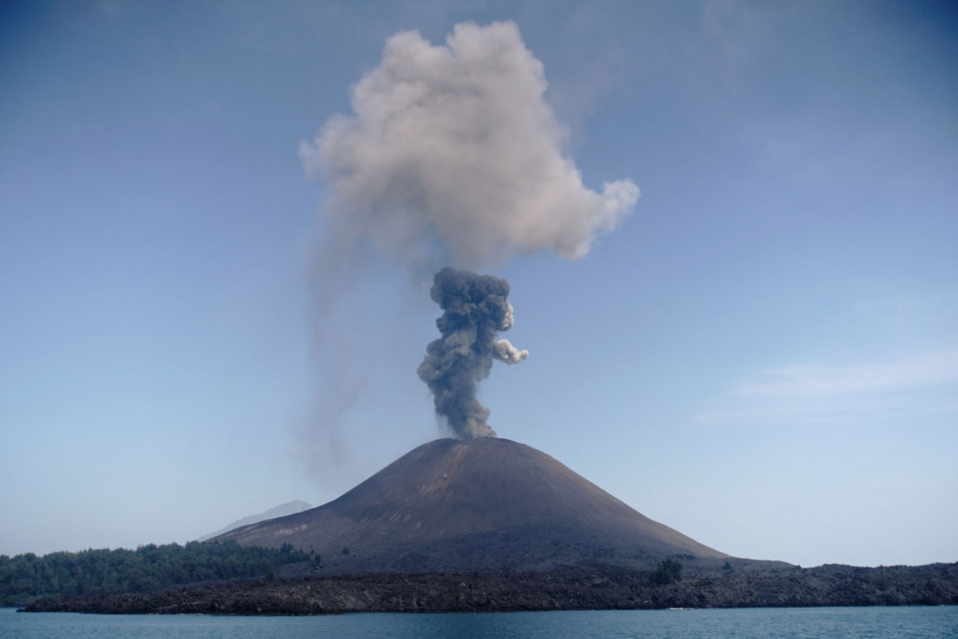 A plume of ash rises from Anak Krakatau on July 18, 2018, as seen from Rakata island in South Lampung regency. (AFP/Ferdi Awed)
T
he government plans to conduct further investigations into the cause of the deadly tsunami that devastated the coasts of Banten and Lampung provinces on Dec. 22, amid heightened public concerns that Anak Krakatau (Child of Krakatau) could trigger.future catastrophes.
Anak Krakatau, which means Child of Krakatau, is located in the middle of the Sunda Strait connecting Sumatra and Java, and emerged in 1927 from the remnants of the 1883 eruption of Mount Krakatau.
The tsunami, which was apparently generated when part of the volcano's flank collapsed underwater, struck coastal areas in the two provinces on Saturday evening,with more than 420 people killed, nearly 1,500 injured and at least 154 still missing, while more than 16,000 people have been dislocated by the disaster.
In the hours immediately following the disaster, authorities disputed as to the tsunami's cause, including an initial statement that the early warning system had not detected an earthquake that could trigger a tsunami. On Monday, the Meteorology, Climatology and Geophysics Agency (BMKG) announced that the tsunami originated from a partial collapse of the volcano, which caused a landslide large enough to generate massive waves.
Coordinating Maritime Affairs Minister Luhut Pandjaitan said that experts from the BMKG, the Agency for the Assessment and Application of Technology (BPPT) and the Energy and Mineral Resources Ministry would be working on a team to perform marine geological and bathymetric surveys in the area surrounding Anak Krakatau.
The team is to start work as soon as conditions are favorable.
Luhut added that the experts had determined that the Sunda Strait tsunami was caused by Anak Krakatau's increasing volcanic activity that had triggered an underwater landslide, dismissing earlier reports that it was caused by an earthquake.
“[The tsunami] was not caused by a volcanic earthquake, but by a 64-hectare section of Anak Krakatau that collapsed,” he said in a statement.
The team concluded on Sunday after analyzing data from seismographs, tide gauges, satellite imagery and interferometers that the volcano’s partial collapse was a result of tremors and high-intensity rainfall. Luhut said the team would soon be dispatched for further analysis.
“Ships cannot [enter the area] right now because the weather is still bad, so the team [could possibly] depart after Dec. 25, perhaps on Dec. 27 or 28, onboard the Baruna Jaya to map the underwater terrain,” he said.
To supplement the surveys, the National Institute of Aeronautics and Space (LAPAN) was to make an independent confirmation through analyzing high-resolution satellite imagery. Meanwhile, the BPPT would conduct an atmospheric survey and the BMKG would review GPS and tidal data in coordination with relevant stakeholders.
The tsunami has triggered debate among scientists and government officials because it struck without a powerful earthquake immediately preceding it, and because the volcano's eruptions, which had been increasing in both strength and frequency since June, had not caused high waves to form.
Prior to Luhut’s statement, BMKG head Dwikorita Karnawati said that Anak Krakatau’s eruptions had collapsed a section of the crater, which resulted in vibrations equivalent to a 3.4-magnitude earthquake. The volcanic material descended in an underwater landslide to trigger a tsunami in just 24 minutes.
The BMKG also said that the volcano had erupted at 9:03 p.m., and that tide gauges in Banten and Lampung had detected a tsunami between 9:27 p.m. and 9:53 p.m.
Meanwhile, the German Research Center for Geosciences (GFZ) reported that it had detected a 5.1-magnitude earthquake that occurred around 25 kilometers east of Anak Krakatau at 8:55 p.m. local time on Saturday.
A time-lapse satellite imagery from the European Space Agency’s Sentinel-1 showed clear loss of land along the volcano's southern flank following the tsunami. The imagery was posted on CATnews (@CATnewsDE), the natural disaster news account managed by Risklayer, a disaster risk think tank affiliated with Germany's Karlsruhe Institute of Technology (KIT).
sentinel-1 satellity imagery analysed: Apparently clear loss of land at southern flank of #anak #krakatoa #volcano. This lead to the #tsunami #landslide affecting #Banten and #Lampung, #Indonesia (post-image from 22:35 UTC, Dec, 22nd) pic.twitter.com/OV8kBcEaId
— CATnews (@CATnewsDE) 23 Desember 2018
The BMKG, the country's highest authority on disaster risk information, said that it did not have immediate access to data on volcanic earthquakes, since more than 90 percent of the earthquakes in Indonesia were tectonic.
President Joko “Jokowi” Widodo has ordered the BMKG to procure tsunami detection equipment, including tsunamis caused by volcanic earthquakes and underwater landslides.
“I have ordered the BMKG to purchase detectors that can warn the public,” said Jokowi.