Popular Reads
Top Results
Can't find what you're looking for?
View all search resultsPopular Reads
Top Results
Can't find what you're looking for?
View all search resultsMap shows deforestation in Indonesia is world's fastest
Planting season: Villagers sow seeds of paddy and other food crops on a plot of land belonging to the state-owned forestry company, PT Perhutani, in Mojokerto, East Java, on Friday
Change text size
Gift Premium Articles
to Anyone
 Planting season: Villagers sow seeds of paddy and other food crops on a plot of land belonging to the state-owned forestry company, PT Perhutani, in Mojokerto, East Java, on Friday. Due to the localsâ heavy dependence on agriculture, Perhutani allow them to till its land during the rainy season. (Antara/Syaiful Arif) (Antara/Syaiful Arif)
P
span class="caption" style="width: 509px;">Planting season: Villagers sow seeds of paddy and other food crops on a plot of land belonging to the state-owned forestry company, PT Perhutani, in Mojokerto, East Java, on Friday. Due to the locals' heavy dependence on agriculture, Perhutani allow them to till its land during the rainy season. (Antara/Syaiful Arif)
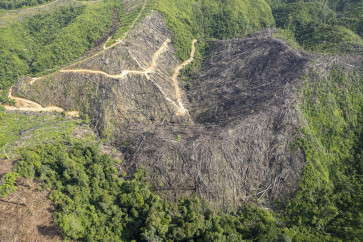
Indonesia has the fastest rate of deforestation in the past 12 years, according to a new global map on deforestation.
A team of researchers from 15 universities ' led by the University of Maryland and assisted by Google and NASA ' has created the first high-resolution global map on Google Earth that maps forest cover.
In a study that was published in the journal Science on Thursday, the researchers reported a global loss of 2.3 million square kilometers of forest between 2000 and 2012 and a gain of 800,000 square kilometers of new forest, with an increase of 2,101 square kilometers of forest loss each year.
Indonesia, according to the study, has experienced the highest rate of deforestation between 2000 and 2012, from around 10,000 square kilometers per year between 2000 and 2003 to around 20,000 square kilometers of deforestation per year between 2011 and 2012.
During the latest period, President Susilo Bambang Yudhoyono actually initiated the forest clearance moratorium to reduce the country's greenhouse gas emissions and rate of deforestation.
The country has lost 15.8 million hectares in total between 2000 and 2012, ranking fifth behind Russia, Brazil, the United States and Canada in terms of forest loss, the study reports.
It finds that Brazil is doing well compared to the other most densely forested countries. It managed to cut its deforestation rate from around 40,000 square kilometers per year to around 20,000 square kilometers per year. But Brazil's success is, however, offset by the increasing deforestation in Indonesia, Malaysia, Paraguay, Bolivia and Zambia
'This is the first map of forest change that is globally consistent and locally relevant,' University of Maryland professor of Geographical Sciences Matthew Hansen, team leader and corresponding author on the Science paper said in a statement.
'Losses or gains in forest cover shape many important aspects of an ecosystem including, climate regulation, carbon storage, biodiversity and water supplies, but until now there has not been a way to get detailed, accurate, satellite-based and readily available data on forest cover change from local to global scales,' he said.
The government was quick to deny the results of the study.
Forestry Ministry secretary-general Hadi Daryanto said that researchers had miscalculated the loss of forest cover, because, according to the data from the ministry, Indonesia only lost around 450,000 hectares of forest every year.
'The scientists only look at satellite images of areas where logging activities are taking place, without putting the country's temporary deforestation into consideration,' Hadi said on Friday.
'Temporary deforestation is, for example, logging activities within the HTI [Industrial Forest Permit] areas, which will be restored after the timber harvesting period concludes. The country harvests only 200,000 hectares of HTI area per year,' he said. 'They should not classify timber harvesting as forest loss,' he continued.
Hadi said that the Forestry Ministry had succeeded in reducing the country's rate of deforestation from 3.5 million hectares per year between 1996 to 2003 to only 450,000 hectares, since the log exports ban was enacted in 2001 and the forest clearance moratorium was introduced, which prohibits the issuance of new licenses for the conversion of primary forests and peatlands in both protected forests and productive forests.
'We also did not issue HTI permits as much as we used to during the forest clearance moratorium. Between 2011 and 2012 the government only issued 250,000 hectares of HTI,' Hadi said. 'Therefore, I don't think this study is stating the truth,' he said.
Hadi said that the government under the Geospatial Information Agency (BIG) would launch the forest clearance moratorium evaluation report in January next year.
As previously reported, Yudhoyono had signed Presidential Instruction No. 6/2013 to continue the forest moratorium for two years in May this year, that was initially introduced in 2011 after Indonesia and Norway signed a US$1 billion deal for Indonesia to reduce its greenhouse gas emissions and rate of deforestation.


