TheJakartaPost
Please Update your browser
Your browser is out of date, and may not be compatible with our website. A list of the most popular web browsers can be found below.
Just click on the icons to get to the download page.

Popular Reads
Top Results
No results found. Please check your search term and try again
Can't find what you're looking for?
View all search resultsPopular Reads
Top Results
No results found. Please check your search term and try again
Can't find what you're looking for?
View all search resultsHundreds flee from Mt. Karangetang activity
Hundreds of residents of Siau, Sitaro Islands regency, North Sulawesi, have fled to safer ground after Mount Karangetang erupted
Change text size
Gift Premium Articles
to Anyone
Share the best of The Jakarta Post with friends, family, or colleagues. As a subscriber, you can gift 3 to 5 articles each month that anyone can read—no subscription needed!

H
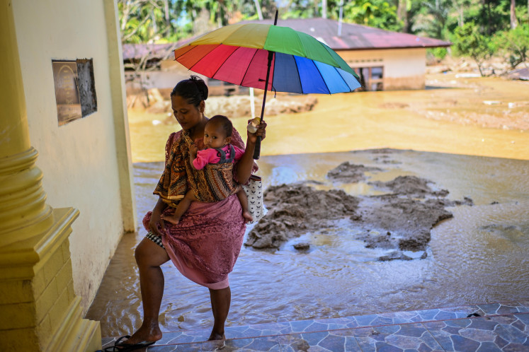
undreds of residents of Siau, Sitaro Islands regency, North Sulawesi, have fled to safer ground after Mount Karangetang erupted.
Mt. Karangetang erupted at 12:30 p.m. local time on Thursday, prompting residents in Bebali subdistrict, East Siau district, in Siau, Tagulandang and Biaro (Sitaro) Islands regency to seek refuge.
Thursday's eruption discharged lava and sent volcanic ash and pyroclastic flows in the direction of the Batuawang River in East Siau district. The eruption caused panic among residents, who fled the area. People initially took shelter in the Bebali subdistrict office, but moved to the East Siau district administrative office in Ulu after volcanic activity increased.
Mt. Karangetang Observation Station head Yudia Tatipang said the volcano's alert status remained the same despite the significant increase in volcanic activity.
'The alert status remains at level 3. Pyroclastic flows frequently occur,' said Yudia by phone.
He added that the volcano activity gave no signs of abating soon. 'Residents are advised not to return home until further notice,' he said.
'This is the first time we have witnessed a massive eruption,' said Bebali district resident Junico Kasiuhe, 35.
According to Junico, Bebeli residents panicked and fled to safety.
'Residents are terrified of the pyroclastic flows as they are rapid and hundreds of lives could be lost in a matter of seconds. That's why we immediately took the initiative to evacuate,' said Junico.
Kanang villager Harto Narasiang said the wind had carried volcanic ash to Karalung and Kanang villages in East Siau district.
'The blanket of ash can be 2 centimeters thick and has affected roads in both villages,' said Harto.
Sitaro Disaster Mitigation Center (BPBD) head Bob Wuaten said village administration offices had evacuated about 2,000 residents.
'The BPBD has evacuated about 465 residents to three shelters from both villages,' said Bob.
Besides the shelters, residents have also taken shelter at other residents' homes. 'We evacuated those living within a 200-meter radius from the lava flow. Currently, four homes have been buried by volcanic ash,' he said.
He added that the North Sulawesi provincial administration, BPBD and the local health office had provided relief aid. He urged residents to remain alert and to wear masks, especially those living along the Batuawang River.
East Siau district chief Wilman Panguliman said there was still volcanic activity as of Friday afternoon, although not as much as Thursday.
He added that aid supplies remained available, but evacuees needed mattresses and blankets.
Mt. Karangetang is also known as Api Siau, or Siau Fire. It is one of the most active volcanoes in Indonesia as it has erupted more than 40 times since 1675 and has had undocumented innumerable minor eruptions. An eruption in 1997 killed three people, while in August 2010 four people went missing during an evacuation effort.
The volcano is among a number of other volcanoes currently showing signs of activity, including mounts Soputan and Lokon in North Sulawesi, Mt. Gamalama in North Maluku, Mt. Slamet in Central Java and Mt. Sinabung in North Sumatra.