TheJakartaPost
Please Update your browser
Your browser is out of date, and may not be compatible with our website. A list of the most popular web browsers can be found below.
Just click on the icons to get to the download page.

Popular Reads
Top Results
No results found. Please check your search term and try again
Can't find what you're looking for?
View all search resultsPopular Reads
Top Results
No results found. Please check your search term and try again
Can't find what you're looking for?
View all search resultsThousands of hotspots detected in peatlands this year
Change text size
Gift Premium Articles
to Anyone
Share the best of The Jakarta Post with friends, family, or colleagues. As a subscriber, you can gift 3 to 5 articles each month that anyone can read—no subscription needed!
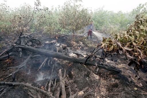 Officers spray water on forest fires in a concession area in Tulung Selapan, Ogan Komering Ilir, South Sumatra, on Oct. 28. Millions of hectares of forest and peatland in Java, Kalimantan, Sulawesi and Papua caught fire during the prolonged drought. (JP/Jerry Adiguna )
T
housands of hotspots have been detected by the government this year, an early warning sign of the rampant forest fires which have in the past caused massive losses in Sumatra and Kalimantan.
National Oceanic and Atmospheric Administration (NOAA) satellites, currently operated from Singapore, detected 1,075 hotspots between January and April, a decrease from 3,411 hotspots in the same period last year, says the Environment and Forestry Ministry.
In contrast, the Terra-Aqua satellites detected 2,710 hotspots, an increase from 1,432 hotspots detected last year.
The main factor for the forest fires is human behavior, although fires also occur due to the damaged peatland ecosystem and the El Niño weather phenomenon, said Kemal Anas, the ministry’s law enforcement director-general on Friday.
The NOAA and Terra-Aqua satellites produced different results because they detect hotspots at different minimum temperatures: 44 and 42 degrees Celsius, respectively.
A hotspot is not to be mistaken for a forest fire as, according to the ministry, a hotspot is an initial indication which could lead to ground checks.
In April, the greatest number of hotspots were found in East Kalimantan (235) and Riau (105) according to NOAA satellites. While Papua (542) and East Kalimantan (286) recorded the highest according to Terra-Aqua satellites.
Failure to contain hotspots last year resulted in the destruction of 2.61 million hectares of forest and peatlands in Sumatra and Kalimantan, leaving 21 people dead and more than a half-a-million people to suffer from respiratory problems as a consequence of the five-month-long choking haze that smothered surrounding areas.
Last year's fire crisis cost the economy Rp 221 trillion (US$16.5 billion), around 1.9 percent of the country's GDP, more than double the cost of rebuilding Aceh after the 2004 tsunami.
According to the Indonesian Forum for the Environment (Walhi), at least 308 forest fires occurred at plantations in concession areas managed by giant corporations including Wilmar, Sinar Mas and APRIL groups, in Sumatra and Kalimantan last year.
The government has reprimanded those companies involved in the fires, with three having land-use or environmental permits revoked and a further 16 seeing permits suspended.
“All corporations with revoked permits are required to turn all of the concession areas over to the government. Suspended corporations are required to hand back burnt areas,” Kemal said. (vps/bbn)