TheJakartaPost
Please Update your browser
Your browser is out of date, and may not be compatible with our website. A list of the most popular web browsers can be found below.
Just click on the icons to get to the download page.

Popular Reads
Top Results
No results found. Please check your search term and try again
Can't find what you're looking for?
View all search resultsPopular Reads
Top Results
No results found. Please check your search term and try again
Can't find what you're looking for?
View all search resultsWest Bandung landslides put Cipularang toll road at risk
The Cikampek-Purwakarta-Padalarang (Cipularang) toll road at kilometer marker (KM) 118 is at risk from landslides that have occured at Sukatani village, West Bandung regency, West Java.
Change text size
Gift Premium Articles
to Anyone
Share the best of The Jakarta Post with friends, family, or colleagues. As a subscriber, you can gift 3 to 5 articles each month that anyone can read—no subscription needed!
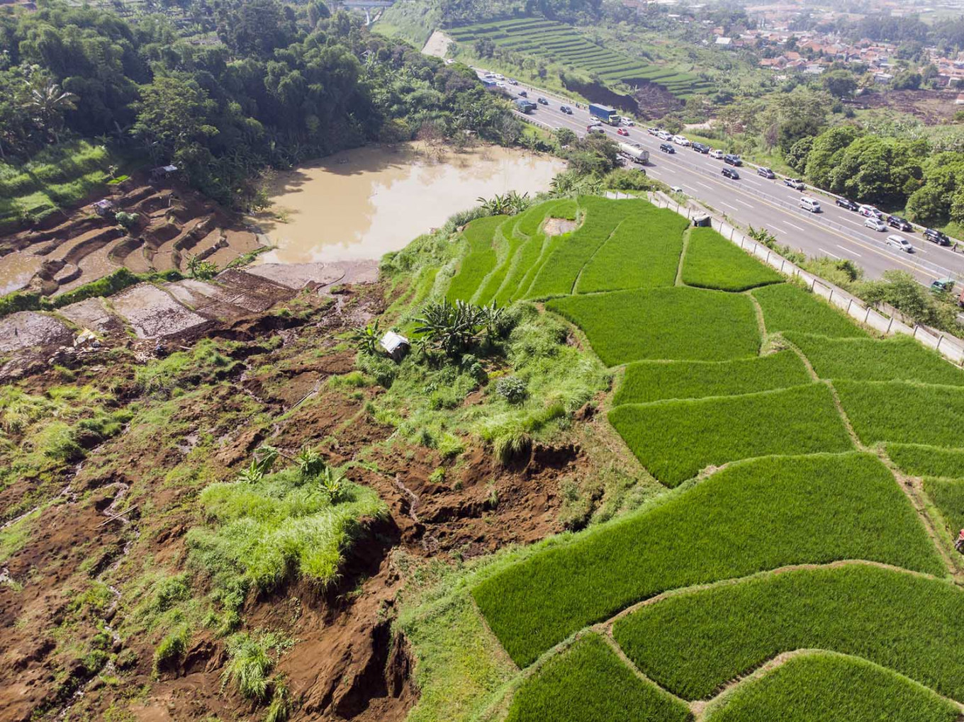 An aerial view of a paddy field that is affected by a landslide at Sukatani Village in Ngamprah district, West Bandung regency of West Java on Wednesday, Feb. 12, 2020. (Antara/M Agung Rajasa)
T
he Cikampek-Purwakarta-Padalarang (Cipularang) toll road at kilometer marker (KM) 118 is at risk from landslides that have occured at Sukatani village, West Bandung regency, West Java.
The land movements have occurred since mid-December 2019, yet the colossal displacement that damaged at least six houses happened on Tuesday, at around 10 p.m.
Earth researcher, Anjar Heriwaseso, from the Center for Volcanology and Geological Hazard Mitigation (PVMBG), said it would be better for the residents in the area to stay alert, as there was still the possibility of more land movements.
“The early mitigation that is being carried out is focused on draining puddles around the location. After they are drained, then [we] can do other structural-mitigation measures, such as slope containment and terracing [soil conservation],” said Anjar, who was gathering ground-surface data and aerial photographs from the location of the landslides on Wednesday.
Head of community unit (RW) 04, Sukatani village, Wahyudin, explained that a landslide, which flattened two resident’s houses, started at 7 p.m. and got worse over the next two hours. The ground movement caused the soil to pile up to dozens of meters in height.
“Two houses were destroyed and four were heavily damaged,” Wahyudin added.
In regard to the threat level, Wahyudin explained that there were still around 80 families residing in the area.
According to provisional field analysis, Anjar said that a possible cause of the landslide was a large puddle that formed due to a blockage at the drainage channel across the toll road. He had yet to come to the conclusion as to whether the puddle was located along the valley of the initial landslide location point. The distance between the point to the toll road is approximately 10 meters.
“Mitigation through draining this water puddle has to be done immediately. [We are] worried that the cliff of yesterday's landslide will [approach] the toll road. It needs to be continuously monitored,” Anjar said, adding that drones were used to help conduct aerial surveillance.
“Ground surface [analysis] to check the condition of the rocks, the structure of the soil, the land formation and irrigation system in the area is all in process. Meanwhile, drones [are being used] to confirm delineation, observing land movements,” Anjar said, explaining that data on the landslide location before the toll road was constructed had to be checked as well to understand its historical structure.
Future land movements were still possible, Anjar noted, especially with the 22-degree steep slope.
“If the slope is disturbed, automatically it will cause [land] movements. If we look at it now, there are numerous disturbances, for example, the changing land use and the movement of heavy vehicles on the toll road,” he said. (ydp)