TheJakartaPost
Please Update your browser
Your browser is out of date, and may not be compatible with our website. A list of the most popular web browsers can be found below.
Just click on the icons to get to the download page.

6.9-magnitude quake strikes off Indonesia: USGS
Change text size
Gift Premium Articles
to Anyone
Share the best of The Jakarta Post with friends, family, or colleagues. As a subscriber, you can gift 3 to 5 articles each month that anyone can read—no subscription needed!
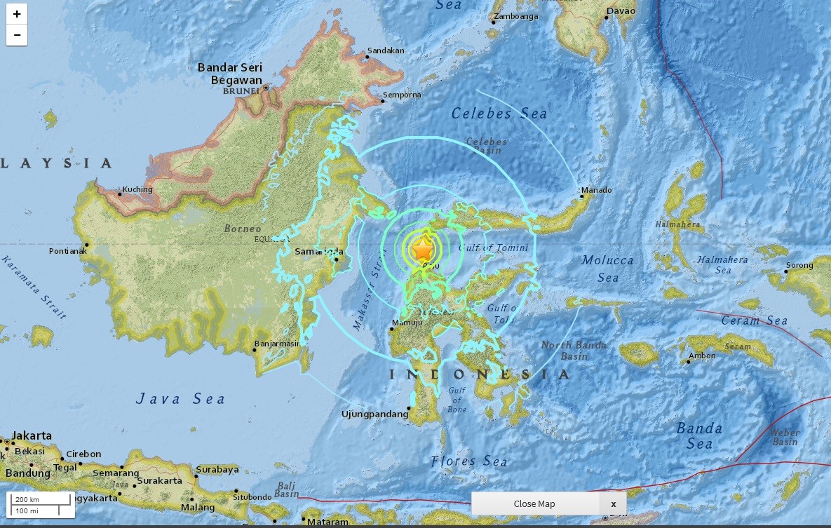 A screen capture of a map from US Geological Survey website of the location of earthquake in Donggala, Central Sulawesi on Sept. 28, 2018 at 5:02 p.m. Jakarta time.A 6.9-magnitude quake struck eastern Indonesia on Friday, the US Geological Survey reported, but there was no tsunami warning issued and no immediate reports of casualties or major damage. (JP/-)
A
6.9-magnitude quake struck eastern Indonesia on Friday, the US Geological Survey reported, but there was no tsunami warning issued and no immediate reports of casualties or major damage.
The undersea tremor struck at a depth of more than 600 kilometers (375 miles) about 220 kilometers south of Katabu on the island of Sulawesi, the agency said, with reports that it was felt hundreds of kilometers away from the epicenter in the Banda Sea.
Deep quakes tend to cause less damage than shallow ones and USGS said there was a low likelihood of casualties and damage.
"We have not received any reports of damage so far", Indonesia's Meteorology, Climatology, and Geophysical Agency said.
An AFP reporter in Kupang, far south of the epicenter, said buildings swayed as the quake hit, prompting frightened residents to run outside.
The Southeast Asian archipelago experiences frequent seismic and volcanic activity due to its position on the Pacific "Ring of Fire", where tectonic plates collide.
In 2018, a 7.5-magnitude quake and subsequent tsunami on Sulawesi island left more than 4,300 people dead or missing.
A devastating 9.1-magnitude quake struck off the coast of Sumatra in 2004, triggering a tsunami that killed 220,000 throughout the region, including around 170,000 in Indonesia.