TheJakartaPost
Please Update your browser
Your browser is out of date, and may not be compatible with our website. A list of the most popular web browsers can be found below.
Just click on the icons to get to the download page.

Popular Reads
Top Results
No results found. Please check your search term and try again
Can't find what you're looking for?
View all search resultsPopular Reads
Top Results
No results found. Please check your search term and try again
Can't find what you're looking for?
View all search resultsSouth China Sea's vague 9-dash line underpins China's claim
China's South China Sea territorial claims are demarcated in vague terms by the nine-dash line, a U-shaped boundary that loops down from Taiwan as far as Indonesia's Natuna Islands.
Change text size
Gift Premium Articles
to Anyone
Share the best of The Jakarta Post with friends, family, or colleagues. As a subscriber, you can gift 3 to 5 articles each month that anyone can read—no subscription needed!
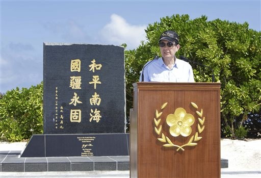 Taiwan's President Ma Ying-jeou speaks during his visit to Taiping Island, also known as Itu Aba, in the Spratly archipelago, south of Taiwan, Jan. 28. (Taiwan Presidential Office via AP/-)
Associated Press
Taiping Island
China's South China Sea territorial claims are demarcated in vague terms by the nine-dash line, a U-shaped boundary that loops down from Taiwan as far as Indonesia's Natuna Islands.
Although China's claim to the area of about 3.5 million square kilometers (1.4 million square miles) is based on historical records and geographic proximity, the nine-dash line is a modern creation. It first appeared on 1947 maps produced by the government of the Republic of China, which was replaced by the communist People's Republic on the mainland just two years later.
While it has tried to stay out of the ongoing territorial disputes, Taiwan inherited the Republic of China's claim when Chiang Kai-shek moved his government to the island ahead of the communist advance. The Taiwanese and Chinese claims now overlap, although China has been seeking to expand its land holdings by creating new islands from reefs and atolls.
Taiwan's biggest territorial holding is Taiping island, lying roughly 2,000 kilometers (1,200 miles) south of Taiwan, where it operates a hospital, airstrip and facilities for roughly 200 residents, mostly coast guard troops.
China has refused requests to clarify the exact geographical coordinates of its South China Sea boundary. It also declines to say whether it considers the South China Sea to be Chinese territorial waters, an exclusive economic zone or some other legal designation.
Beijing says that in no way impedes freedom of navigation, and its diplomats accuse others of picking fights. However, rising tensions, including Indonesia's worries over China's designs on waters around the Natuna Islands, threaten to make China's preference for ambiguity no longer tenable.