TheJakartaPost
Please Update your browser
Your browser is out of date, and may not be compatible with our website. A list of the most popular web browsers can be found below.
Just click on the icons to get to the download page.

Popular Reads
Top Results
No results found. Please check your search term and try again
Can't find what you're looking for?
View all search resultsPopular Reads
Top Results
No results found. Please check your search term and try again
Can't find what you're looking for?
View all search resultsHaze caused thousands of deaths in RI in 2015: Study
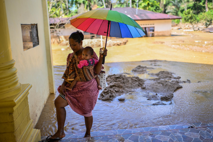
Health risk: Smoke billows from a burning area of land in Pampangan, Ogan Komering Ilir, South Sumatra, on Saturday
Change text size
Gift Premium Articles
to Anyone
Share the best of The Jakarta Post with friends, family, or colleagues. As a subscriber, you can gift 3 to 5 articles each month that anyone can read—no subscription needed!

H
span class="caption">Health risk: Smoke billows from a burning area of land in Pampangan, Ogan Komering Ilir, South Sumatra, on Saturday. The National Institute of Aeronautics and Space (Lapan) recently reported 197 hot spots in Indonesia.(Antara/Nova Wahyudi)
As fires continue to raze forests and peatland in Sumatra and Kalimantan, a wake-up call has come from a group of researchers who estimate that haze produced on the islands potentially caused 100,000 deaths in the region in 2015.
The team of public health and atmospheric modelling scientists from Harvard and Columbia universities estimated that 2,200 premature deaths occurred in Singapore, 6,500 in Malaysia and 91,600 in Indonesia due to the haze last year.
The estimate is much greater than the official number given by the Indonesian government, which said only 19 people died from the haze in that period.
“Now fires are back again. If nothing changes, this killer haze will carry on taking a terrible toll, year after year. Industry and government must take real action to stop forest clearing and peatland drainage for plantations,” Greenpeace Indonesia forest campaigner Yuyun Indradi said on Monday during the release of the study.
The haze is an annual problem caused by fires started in forests and on carbon-rich peatland in Indonesia to quickly and cheaply clear land for oil palm and pulpwood plantations.
The blazes occur mainly on the islands of Sumatra and Kalimantan, with monsoon winds often blowing the haze over to Singapore and Malaysia.
Last year’s fires were among the worst in memory, cloaking large parts of the region in choking smog for weeks, causing half a million people to suffer respiratory illnesses and sending diplomatic tensions soaring.
As there has previously been no detailed research estimating the haze’s death toll in Southeast Asia, the study is expected to put more pressure on the Indonesian government to take swift action. “Now that we know the scale of the death toll, failure to act immediately to stem the loss of life would be a crime,” Yuyun said.
The government has stepped up efforts to address the problem in the past year, including probing companies and individuals suspected of starting the fires.
There have been concerns over the government’s commitment as police have terminated several cases and courts have ruled in favor of companies.
Fires once again started to raze parts of Sumatra and Kalimantan last month. In Bengkalis, Riau, the local administration decided to temporarily close down schools as the haze thickened.
The Environment and Forestry Ministry and the Peatland Restoration Agency (BRG) have made impromptu visits to plantations suspected to be sources of fires in Riau but were blocked by the plantation companies’ security guards. Hot spots continue to emerge in Riau, South Sumatra as well as Central and West Kalimantan.
The government quickly downplayed the findings of the study. “I’m not sure the number paints a realistic picture. If it’s only a statistical calculation, I think it’s not right to conclude such a huge death toll,” the Health Ministry’s director general for disease control and environmental health, M. Subuh, told The Jakarta Post.
The environment ministry also dismissed the study, questioning its methodology. “How can you detect dead people using a satellite? It doesn’t make sense,” the ministry’s forest fire mitigation director, Raffles Brotestes Panjaitan, told the Post.
He added that the Indonesian government’s data was more valid than that compiled in the study. “We collected data from all provinces and all government agencies collaborated with us, from the Health Ministry, the National Disaster Mitigation Agency [BNPB] to regional administrations,” Raffles said.
The peer-reviewed study, published on Monday, used air pollution readings and satellite data to calculate forest fire smoke exposure.
To assess the data, the scientists used a new analytical framework called the GEOS-Chem chemical transport model.
The estimated death toll is high because many of the affected areas are peatland, which contains high levels of combustible organic material.