TheJakartaPost
Please Update your browser
Your browser is out of date, and may not be compatible with our website. A list of the most popular web browsers can be found below.
Just click on the icons to get to the download page.

Popular Reads
Top Results
No results found. Please check your search term and try again
Can't find what you're looking for?
View all search resultsPopular Reads
Top Results
No results found. Please check your search term and try again
Can't find what you're looking for?
View all search results[UPDATED] Central Sulawesi quake: What we know so far
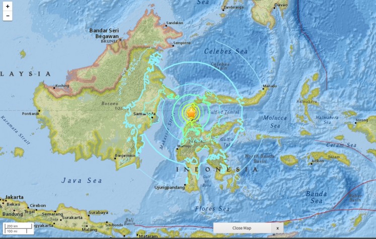
A tsunami hit Palu, Donggala and Mamuju in Central Sulawesi on Friday evening, triggered by a 7.4 magnitude earthquake that rocked the province at 5:02 p.m. Jakarta time.
Change text size
Gift Premium Articles
to Anyone
Share the best of The Jakarta Post with friends, family, or colleagues. As a subscriber, you can gift 3 to 5 articles each month that anyone can read—no subscription needed!
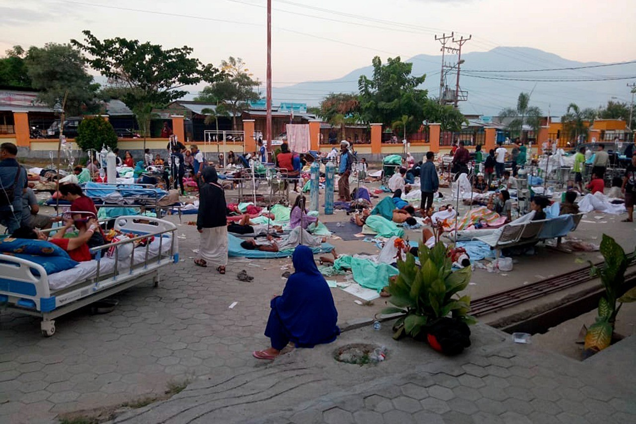 Victims receive treatments in front of a hospital in Palu, Central Sulawesi, on Saturday, Sept. 29, 2018, amid threats of aftershocks. (Antara/BNPB Sutopo Purwo Nugroho)
A
tsunami hit Palu, Donggala and Mamuju in Central Sulawesi on Friday evening, triggered by a 7.4 magnitude earthquake that rocked the province at 5:02 p.m. Jakarta time. The epicenter of the quake is about 27 kilometers northeast of Donggala and 10 km deep.
Prior to the earthquake, in the afternoon, Donggala regency was hit by a 6.0 magnitude quake that killed at least one and injured several others. The quake struck about 2 km north of Donggala at a depth of 10 km and lasted 10 seconds. The earthquake was followed by several aftershocks of magnitudes between 3.2 and 5. The main quake was felt in Donggala, Palu and Poso.
Soon after the evening quake, a tsunami warning for Central Sulawesi was issued at 5:07 p.m. The warning, however, was revoked around 30 minutes later.
Soon, pictures and video footage of buildings being hit by water went viral on social media. Confusion ensued due to a lack of information from the National Disaster Mitigation Agency (BNPB) as communications were cut off.
It was only later that the BNPB confirmed that a tsunami had occurred. Its wave reached 1.5 meters high and hit, among other structures, Palu Grand Mall and Baiturrahman Mosque, both located near the coastline.
On Wednesday, the Palu Meteorological, Climatology and Geophysics Agency (BMKG) in Central Sulawesi said the region had been rocked by 30 earthquakes daily over the last four months. The daily quakes were caused by shifts in the Palu-Koro fault, which extends from Poso to the waters of Tolitoli regency and branches off to the Matano fault in South Sulawesi.
The Central Sulawesi administration has declared a 14-day state of emergency, from Sept. 28 to Oct. 11. According to Statistics Indonesia (BPS), Central Sulawesi’s population reached nearly 3 million people in 2016. From the total, Palu city was home to at least 374,000 residents and Donggala regency at least 296,400 people.
Cause of quakes, tsunami
BNPB spokesman Sutopo Purwo Nugroho said the first quake, which hit at 2 p.m., was caused by a Palu-Koro thrust fault that stretched from Palu to Teluk Bone.
On Saturday morning, Sutopo explained in a tweet that the Palu-Koro fault was very active and its movement might have caused a submarine landslide that triggered the tsunami. Sutopo said more research was needed.
Analisis geologi penyebab gempa 7,7 SR di Sesar Palu Koro diikuti tsunami yang menerjang Kota Palu. Sesar ini sangat aktif bergerak dan melintas Kota Palu. Adanya mekanisme gerak ke atas dan kemungkinan longsor bawah laut menyebabkan tsunami. Para ahli masih melakukan kajian. pic.twitter.com/otuueMc7RM
— Sutopo Purwo Nugroho (@Sutopo_PN) September 28, 2018
Analisis sementara ahli tsunami dsri ITB berdasarkan modeling dan kajian sebelumnya bahwa tsunami di Palu disebabkan adanya longsoran bawah laut saat gempa 7,7 SR mengguncang Donggala. Teluk Palu dan pesisir Donggala memang rawan tsunami. Masih dilakukan kajian lagi. pic.twitter.com/1YbHEFmTfT
— Sutopo Purwo Nugroho (@Sutopo_PN) September 29, 2018
The Center of Volcanology and Geological Hazard Mitigation has said the deteriorating Palu-Koro fault had amplified the jolt of the 7.4-magnitude earthquake that hit Donggala regency.
“The geological map of Central Sulawesi is composed of rocks that are aged between 10,000 and 1 million years. But it fell into decay, causing the jolts to be stronger,” said the institution’s head of earthquake mitigation, Sri Hidayati, on Saturday.
Scientists argued that the shape of Palu bay has worsened the tsunami.
Death toll
As of Friday evening, the government had yet to receive reports about the number of victims who died in the disaster because the communications system was damaged.
Komang Adi Sujendra, the head of the Indonesian Medical Association (IDI) Central Sulawesi, said in a video on Saturday morning that at Central Sulawesi General Hospital (RSUD) alone, 30 were dead and at least 21 injured.
At around 2 p.m. on Saturday, the BNPB announced that at least 384 people are dead, 29 missing and 540 injured as rescue teams scoured the ravaged city of Palu.
“Updated numbers of the victims show that 384 people died, 29 are missing and 540 are injured. Donggala is still unreachable because communications are still cut off. A team has been dispatched to the regency,” Sutopo said.
He added that the number of victims was likely to increase because the rescue teams have yet to reach other affected areas.
On Sunday morning, the National Disaster Mitigation Agency (BNPB) announced that at least 405 people are dead, 29 missing and 540 injured as rescue teams scoured the ravaged city of Palu.
The BNPB announced on Sunday afternoon that the death toll has risen to 832. Around 821 victims have been found in Palu, while the rest have been found in Donggala.
BNPB also estimates 71 foreign tourists have been affected by the earthquake and tsunami. Authorities had found 66 of the foreigners and declared them safe.
A number of areas in Central Sulawesi have been hit by large amounts of mudflow following the earthquake and tsunami. It is feared that about 2,000 people in the subdistrict are dead, with homes having been dragged away by the mud. According to Sutopo, the mud was caused by soil liquefaction had occurred, a natural phenomenon that takes place when solid soil loses its strength and behaves like liquid due to stress such as shaking during an earthquake.
The BNPB announced on Tuesday afternoon that the death had risen to 1,234. At least 799 people are injured and 99 missing.
As of Oct.11 morning, 2,073 people are dead (Palu, 1,663; Sigi, 223; Donggala, 171; Parigi Moutong, 15; and Pasangkayu in West Sulawesi, 1), including 519 victims who have been buried, 2,549 people are severely injured and receiving treatment at hospitals while 113 have been declared missing. The disaster resulted in 87,725 evacuees spread across 141 points. The number might rise once the victims from Petobo and Balaroa, which were devastated by soil liquefaction after the earthquake, are accounted for.
As of Oct. 21, 2,256 people have been killed, 4,612 injured and 223,751 displaced.
As of Oct. 28, 2,086 people have been killed, 4,438 injured, 1,309 lost and 206,524 displaced.
Liquefaction: 'Mud rolling like waves'
Large amounts of liquefied soil have hit several areas in Central Sulawesi following the Sept. 28 earthquake and tsunami. It is feared that about 2,000 people in Petobo subdistrict were killed when the liquefied soil dragged away and submerged dozens of homes.
According to the BNPB’s Sutopo, the slurry was caused by soil liquefaction, a process that is triggered by geological stressors like an earthquake that collapses the structure of the soil, so it behaves like a fluid.
The United States Geological Survey (USGS) defines liquefaction as "a process by which water-saturated sediment temporarily loses strength and acts as a fluid". The USGS further notes that the "highest hazard areas are concentrated in regions of man-made landfill, especially fill that was placed many decades ago in areas that were once submerged bay floor".
A 2012 report from the Energy and Mineral Resources Ministry’s Indonesian Geological Agency stated that Palu, which is among the many regions in the country with high seismic activity, has a high risk of soil liquefaction because saturated or partly saturated sediments and shallow groundwater was characteristic of local geological conditions.
Taufiq Wira Buana, a researcher with the agency, warned that liquefaction could occur if Palu was hit by another large earthquake of magnitude 6.5 or more. He added that since liquefaction could not be prevented given the geological characteristics of the area, the potential destruction and casualties resulting from such an event might be reduced by designing buildings accordingly.
Scale of destruction
There is no definitive data on the scale of destruction in the region. Damage estimates can only be determined via pictures and videos spread online. Communications have been cut off, making it hard to find information.
Video footage of the tsunami shows that the wave swept away several small buildings on the coastline. Pictures and videos show the iconic Ponulele Bridge, a major tourist attraction located near the coast of Palu, as having collapsed. At least three hotel buildings in Palu had collapsed with guests inside the buildings.
Kondisi sebelum dan setelah gempa 7,7 SR di Donggala yang berdampak hancurnya jembatan Ponulele di Kota Palu. Sumber gempa berasal dari Sesar Palu Koro yang aktif bergerak dan melintasi Kota Palu. pic.twitter.com/bMgbbsY23L
— Sutopo Purwo Nugroho (@Sutopo_PN) September 28, 2018
Hundreds of residents in Palu are pumping fuel manually from gas stations around the city as none the city’s gas stations are in operation. State-owned oil and gas holding company Pertamina has set up an emergency aircraft fuel post in Palu and an emergency fuel terminal in Donggala.
Mutiara Sis Al Jufri Airport in Palu is closed due to damages caused by the earthquake. A notification letter from AirNav Indonesia announced on Friday evening that the closure would be effective from 7:26 p.m. local time on Friday until 7:20 p.m. on Saturday. The airport suffered damages to its navigation system as well as 500 meters of its 2,500-m-long runway as a result of the earthquake, which made it impossible for large aircraft to land.
Indonesian Flight Navigation Service Institution (AirNav Indonesia) spokesperson Yohanes Sirait said in a statement on Sunday that the airport had finally reopened commercial flight services after only being open for emergency flight services. Current flights to and from the airport were navigated with visual flight rules navigation.
dapet kikriman foto donggala palu saat ini #PrayForPalu #PrayForDonggala pic.twitter.com/dEvHiwiTFr
— Kol.JalalHusin ㊙️ (@PanglimaHansip) September 29, 2018
The National Disaster Mitigation Agency (BNPB) announced that at 65,733 houses were damaged by the earthquake.
As of Oct. 21, BNPB estimated that the disaster resulted in at least Rp 13.82 trillion (US$911 million) in economic losses. The Rp 13.82 trillion in economic losses consisted of Rp 1.99 trillion in lost income and Rp 11.83 trillion in physical damage.
Around 68,451 houses, 327 places of worship, 265 schools, 78 offices and 362 shops were damaged in the quake.
Confusion over tsunami warning
Critics have questioned why the agency decided to revoke the warning when a tsunami did take place.
BMKG chairwoman Dwikorita Karnawati claimed the warning was revoked after the agency learned the tsunami was over.
She also claimed that the height of the waves had decreased gradually, prompting the agency to revoke the tsunami warning status at 5:36 p.m.
According to the BNPB, the BMKG had initially given a different reason for its decision to change the status.
“The decision was based on visual monitoring and further monitoring using the equipment [tsunami detection buoys] at sea for 30 minutes. The BMKG did not see any significant change in the sea level. That’s why they ended the alert,” BNPB spokesman Sutopo Purwo Nugroho said in a statement.
Tsunami expert Abdul Muhari criticized the BMKG’s decision to end the tsunami warning early after the agency had obtained witness reports of a 1.5-m high wave.
“If witnesses said they saw a wave with a height of more than 1 meter, authorities should not have ended the warning, because more waves could have hit at any time soon after. Until authorities can confirm that the tsunami is over, the warning should be kept,” Abdul told The Jakarta Post on Friday.
He added that authorities might not be able to reach a conclusion immediately because they lacked the proper equipment to measure the height of the sea level both from land and in the water, as the only tide gauge available was located around 400 km away in Mamuju.
Disaster relief efforts
Coordinating Political, Legal and Security Affairs Minister Wiranto led a meeting with ministers and state institutions on Friday evening to set a plan of action that will involve the deployment of personnel, dispatch of aid and reparation of damaged facilities.
Mutiara Sis Al Jufri Airport is partly damaged. However, the government said it expected that the remaining 2,000 m of the runway could still be used for the landing of a Hercules cargo aircraft and CN-235 aircraft, which authorities would use to speed up the deployment of personnel and delivery of aid, including medical assistance and food supplies.
"The Transportation Ministry will deploy one helicopter from Makassar to Palu while bringing navigation equipment, which will be used to handle aircraft that can deliver supplies," he said, adding that, by Saturday morning, the runway was expected to be used for landing by the Hercules aircraft.
Indonesian Military (TNI) personnel stationed near the affected areas and officials from Gorontalo, Mamuju and Makassar were working to help clear building debris to find and rescue any victims who might be trapped, Wiranto said.
Sutopo said in an update that, as of 9:19 a.m. on Saturday, military personnel and aid totaling 6,943 kilograms had been sent to Palu.
83 personel TNI dan bantuan barang seberat 6.943 Kg dikirim ke Palu menggunakan pesawat Hercules. Barang yang diangkut:
1.Tenda Pleton = 3 Unit
2. Velbed = 83 Unit
3. Alat Operasi
4. Genset = 1 Unit pic.twitter.com/b0NOUwCwsy
— Sutopo Purwo Nugroho (@Sutopo_PN) September 29, 2018
Groups and individuals were reportedly coming until late on Saturday night to give aid such as food and drinks, menstrual pads, diapers, clothes and tents to the camp.
The BNPB will assist the regional administration during the emergency period, especially in relation to disaster fund usage. The government has pledged Rp 560 billion (US$37.6 million) in relief funds. The amount might be increased to meet future needs for aid and infrastructure reconstruction.
Social Affairs Minister Agus Gumiwang Kartasasmita said the ministry had deployed six communal kitchens from Gorontalo, West Sulawesi and South Sulawesi to provide at least 2,000 meals, three times a day, for the survivors.
The Health Ministry is also sending medical professionals and medicines to help survivors in the provincial capital city of Palu.
Editor's note (Oct. 11, 2018): This article has been updated with a section on soil liquefaction and latest death toll.
Editor's note (Oct. 22, 2018): This article has been updated with latest death toll.