TheJakartaPost
Please Update your browser
Your browser is out of date, and may not be compatible with our website. A list of the most popular web browsers can be found below.
Just click on the icons to get to the download page.

Popular Reads
Top Results
No results found. Please check your search term and try again
Can't find what you're looking for?
View all search resultsPopular Reads
Top Results
No results found. Please check your search term and try again
Can't find what you're looking for?
View all search resultsAirplanes flying in Makassar sky as ‘tsunami’ clouds unfold
Thunderclouds that formed above a Makassar airport in South Sulawesi on the first day of 2019 delayed the landing of five airplanes and caused anxiety among residents who were still reeling from two recent tsunamis.
Change text size
Gift Premium Articles
to Anyone
Share the best of The Jakarta Post with friends, family, or colleagues. As a subscriber, you can gift 3 to 5 articles each month that anyone can read—no subscription needed!
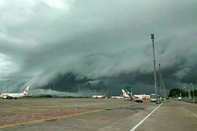 Thunderclouds unfold in the sky above Sultan Hasanuddin International Airport in Makassar, South Sulawesi, on Tuesday afternoon.
(kompas.com/-)
Thunderclouds unfold in the sky above Sultan Hasanuddin International Airport in Makassar, South Sulawesi, on Tuesday afternoon.
(kompas.com/-)
F
ive aircraft were left flying above a Makassar airport in South Sulawesi on Tuesday afternoon after cumulonimbus clouds surrounded the area, forming wave-like clouds that some said resembled a tsunami.
The aircraft stayed airborne for about 20 minutes as they waited to be cleared for landing at Sultan Hasanuddin International Airport. During that time, local air traffic control prevented them from touching down because the clouds were exceedingly dark and posed lightning risks.
The clouds caused panic among local residents who were still reeling from the Sunda Strait tsunami, which recently hit Banten and Lampung on Dec. 22, killing more than 400.
The neighboring province of Central Sulawesi was also hit by a natural disaster recently when a strong earthquake triggered a tsunami that ravaged the Palu Bay on Sept. 28, killing more than 2,000.
Recordings of the clouds were posted on social media by several people.
“What sign is this??? Clouds in the form of ocean waves, makassar, south Sulawesi. [God] grant us patience and protect us from all these trials,” said Twitter user @Nunuf4.
Pertanda apa ini??? Awan bentuk ombak, makassar, sulawesi selatan.
Berilah kesabaran dan lindungi kami atas semua ujianmu🙏 pic.twitter.com/IQ85Hsq069
— Nu' (@Nunuf4) January 1, 2019
“On the first day of 2019, Makassar sky gives [a] beautiful ‘show’. Clouds in the form of tsunami waves appear in the sky. But keep calm. Forecaster said it is a usual phenomenon and has occurred in other countries,” commented another user, @P3nj3l4j4h.
The general manager of the Makassar division of state-owned air navigation firm AirNav Indonesia, Novy Pantaryanto, said all five planes landed safely after the sky grew clearer.
“Cumulonimbus clouds are dangerous. These clouds can freeze plane engines because many ice particles are inside them. There is also lightning in them,” he said as quoted by kompas.com on Wednesday.
Novy said the airport's traffic control tower was prepared to deal with the clouds, as its radar could detect weather conditions within a radius of 100 kilometers and, as such, properly direct pilots.
He added that such thunderclouds usually occurred at a height between 1,000 to 15,000 feet and that planes normally flew at 30,000 to 40,000 feet, so the airplanes were basically safe so long as they maintained their height.
Nur Asia Utami, an official with the Meteorology, Climatology and Geophysics Agency's (BMKG) Makassar branch, said the cumulonimbus clouds on Tuesday were quite major.
“It’s dangerous because they cause heavy rain with lightning and strong winds. They usually disappear within one to two hours,” she said.
Nur said such clouds could occur along the western and southern coasts of South Sulawesi.
“It can occur in several parts of South Sulawesi. It could even reappear in Makassar again,” she said.