TheJakartaPost
Please Update your browser
Your browser is out of date, and may not be compatible with our website. A list of the most popular web browsers can be found below.
Just click on the icons to get to the download page.

Popular Reads
Top Results
No results found. Please check your search term and try again
Can't find what you're looking for?
View all search resultsPopular Reads
Top Results
No results found. Please check your search term and try again
Can't find what you're looking for?
View all search resultsMountains rumbling: Five most active volcanoes in the archipelago
Here are five of the most active volcanoes that have rumbled recently:
Change text size
Gift Premium Articles
to Anyone
Share the best of The Jakarta Post with friends, family, or colleagues. As a subscriber, you can gift 3 to 5 articles each month that anyone can read—no subscription needed!
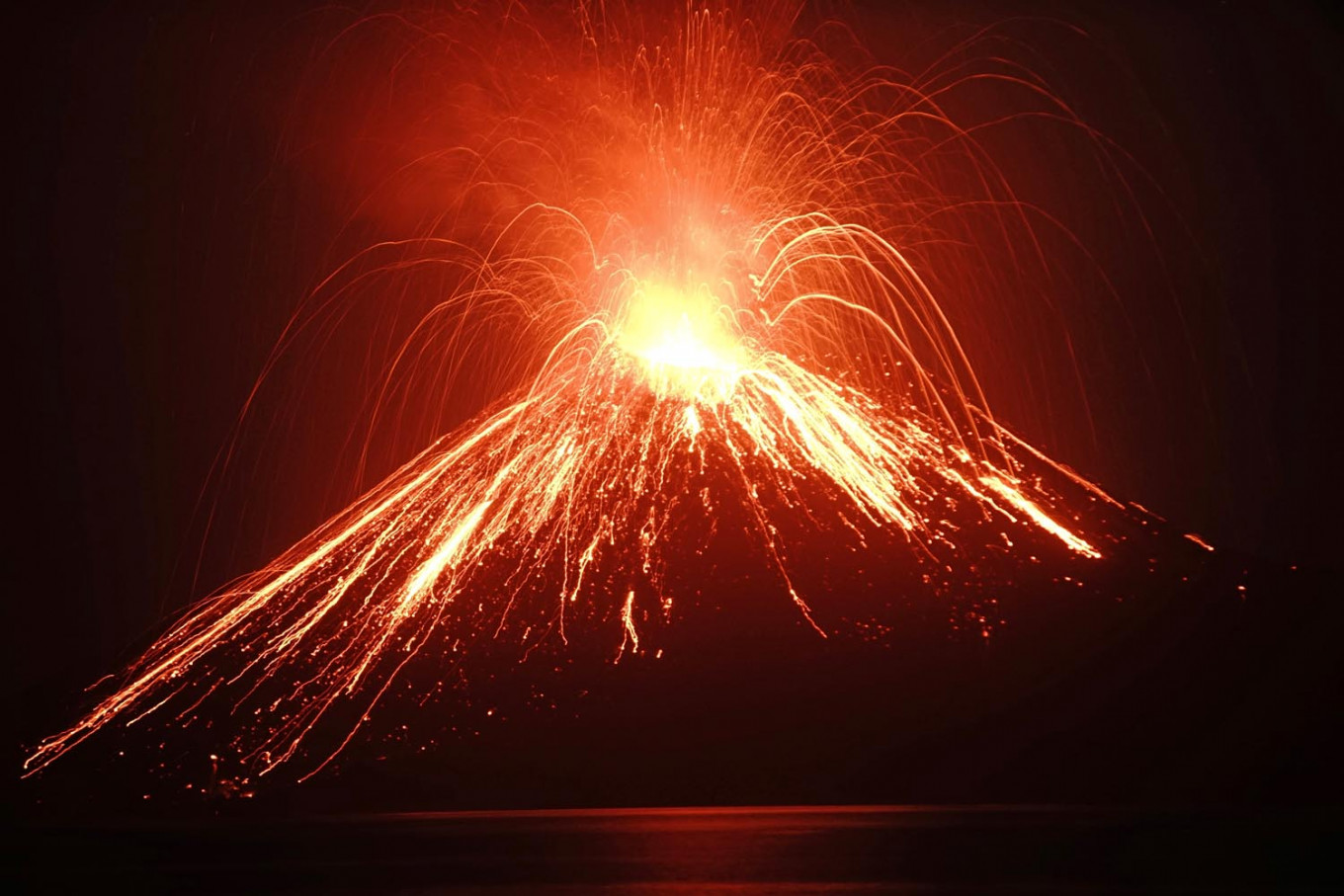 Lava streams down from Anak Krakatau (Child of Krakatoa) volcano during an eruption as seen from Rakata island in South Lampung on July 19, 2018. (AFP/Ferdi Awed)
T
he eruption of little-known volcano Mount Karangetang in Siau Island, North Sulawesi, has added to the list of active volcanoes that have recently awakened in the archipelago, home to more than 230 million people.
Indonesia has more than 120 volcanoes, 20 of which have been considered to be the most active, according to the latest data from the Volcanology and Geological Disaster Mitigation Center (PVMBG).
The most active volcanoes are placed into three alert levels by local authorities: level II of Waspada (Caution), level III of Siaga (Alert) and level IV of Awas (Danger) – the highest on the alert level.
Here are five of the most active volcanoes that have rumbled recently:
Mount Karangetang
Mount Karangetang in Siau Island, North Sulawesi, located roughly 146 kilometers from the provincial capital of Manado, has been erupting since November last year. Its activity has only increased since then, prompting the PVMBG to declare an Alert status in December.
As of Sunday, local observation posts said that volcanic activity had been fluctuating, with a number of volcanic earthquakes occurring in the last several days. Officials also observed a flow of lava from one of the craters.
The situation prompted local residents to leave their homes and take shelter at a safe location. As of Sunday, at least 216 residents have taken refuge while around 499 have been isolated in their homes in Batubulan village near the mountain.
Authorities have been working to reach the isolated residents through the sea, as all land roads were already blocked due to the eruption.
Mount Agung
The latest eruption from the volcano, located in Karangasem regency, Bali, occurred on Dec. 30. Since then, it has erupted several times, with the latest occurring on Friday. During the latest eruption, local observation posts reported lava spewing from the crater.
The PVMBG said the volcano had been placed under Alert status, while the danger zone was still within a radius of 4 kilometers from the peak.
Sungguh memesona gunungnya! Di balik erupsi Gunung Agung pada November 2017 lalu meninggalkan kenangan yang amat indah. Deretan gunung-gunung menambah pesona dan eksotisme bagi penikmat alam semesta. pic.twitter.com/n1bfHqPcik
— Sutopo Purwo Nugroho (@Sutopo_PN) June 30, 2018
In 2017, the volcano erupted multiple times, causing a tourism slowdown that saw around 1 million fewer tourists visiting the island. Authorities estimated Rp 11 trillion (US$783 million) in losses for tourism-related businesses. The eruption also urged authorities to temporary close Ngurah Rai International Airport as well as cancel inward and outward flights.
Since then, the government has been wooing tourists to return to Bali by declaring the volcano safe for tourists as long as they stay outside the 4-km danger zone from the peak.
BNPB spokesman Sutopo Purwo Nugroho has been an avid supporter of volcano-related tourism.
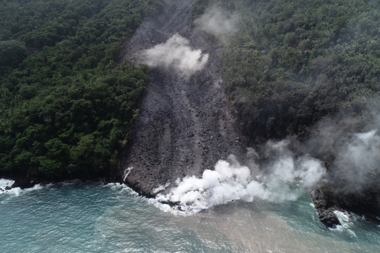
Mount Anak Krakatau
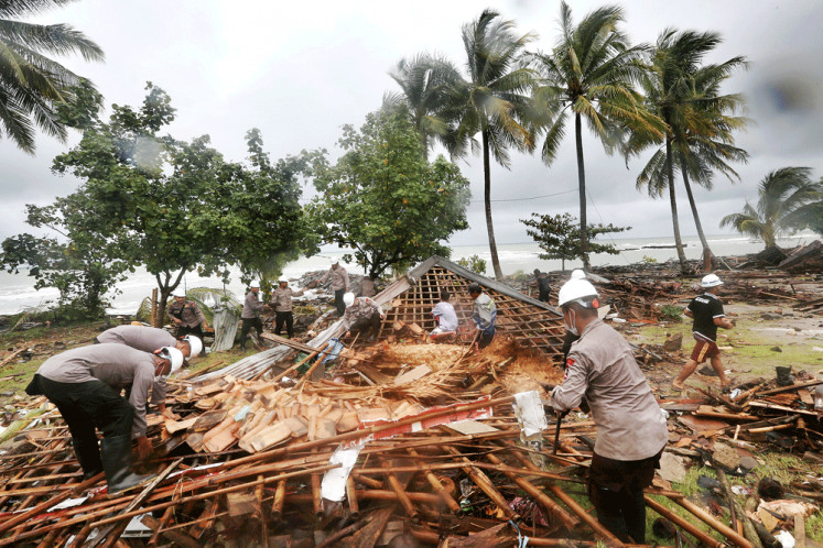
Mount Anak Krakatau, which had been on Alert level since Dec. 27, erupted on Dec. 22 last year. The eruption was a contributing factor of a tsunami hitting Banten and Lampung on the same day.
The tsunami, reaching as high as 3 meters according to the Meteorology, Climatology and Geophysics Agency (BMKG), was caused by an abnormal tidal wave surge due to a full moon and an underwater landslide following the eruption of Anak Krakatau Volcano. According to the National Disaster Mitigation Agency (BNPB), at least 426 people died, and 23 others were lost during the disaster.
The latest eruption also shrunk the volcano to almost a third its original height, from 338 m to 110 m.
The PVMBG concluded on Dec. 30 that the eruption of Mount Anak Krakatau had stopped based on data from satellite imagery and weather observations. This, however, did not rule out the possibility of the volcano in the Sunda Strait erupting anew in the near future.
On Monday, the PVMBG said it had not recorded eruptions from the volcano from Feb. 4 to 11.
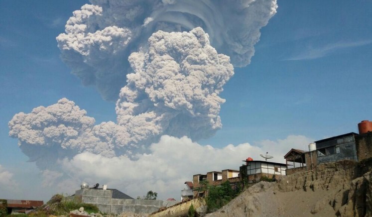
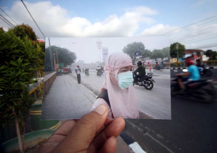
Mount Sinabung
Mount Sinabung observation post officer Arief Cahyo Purnomo said in December that the volcano’s activity had decreased over the last few months. The office has not recorded eruptions since June 2018. The volcano first erupted in August 2010 for the first time in hundreds of years.
The local authority, however, maintained its status at Danger, the highest of the official four-level warning system. The 2,400-meter volcano is still under 24-hour supervision.
In a recent turn of events, the mountain showed some good news. According to a report from PVMBG on Monday, no eruption occurred on Mount Sinabung between Feb. 4 and 10. The mountain’s crater, however, was seen of spewing thin white smoke that reached 400 meters from its peak. Authorities also recorded dozens of earthquakes, including a volcanic one, occurring within the week.
Mount Merapi
Mount Merapi in Central Java has yet to show any significant increase in its volcanic activities since one of its largest eruption in 2010. At that time, more than 350 people were killed while 350,000 others were displaced. Most of the victims lived on the volcano’s slopes.
The volcano, one of the world’s most active, is located at the point where four regencies meet: the Central Java regencies of Magelang, Boyolali and Klaten, and Sleman regency in Yogyakarta.
Mt. Merapi's warning status on Monday, was still Caution the second of the four-tiered national volcano alert system that has been in place since May 2018. Despite the relatively low alert status, local observation posts have seen heightened volcanic activity in mid-January, as Mount Merapi spewed incandescent lava from its crater.
Local residents stayed on guard due to the heightened activity by increasing the frequency of their independently organized patrols tasked to remind other people to stay out the danger zone of 3-kilometer radius from the crater.