TheJakartaPost
Please Update your browser
Your browser is out of date, and may not be compatible with our website. A list of the most popular web browsers can be found below.
Just click on the icons to get to the download page.

Popular Reads
Top Results
No results found. Please check your search term and try again
Can't find what you're looking for?
View all search resultsPopular Reads
Top Results
No results found. Please check your search term and try again
Can't find what you're looking for?
View all search resultsIndonesia's maritime plans may mean welcoming new neighbors
Indonesia has made several submissions to the relevant UN body to stake its claim on additions to its maritime space, which might bring new neighbors, too.
Change text size
Gift Premium Articles
to Anyone
Share the best of The Jakarta Post with friends, family, or colleagues. As a subscriber, you can gift 3 to 5 articles each month that anyone can read—no subscription needed!
I
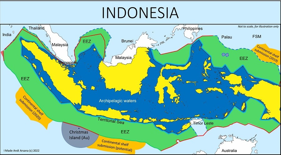
ndonesia’s maritime space is exceptionally large. Being an archipelagic state, the country’s maritime zone is a lot larger than its land territory. With its already vast seas, Indonesia aims to extend its maritime zones through several submissions to the United Nations. One submission was made on April 11, 2019 regarding an area north of Papua (Eauripik Rise) and another on Dec. 28, 2020 for an area southwest of Sumatra.
The above submissions are currently under consideration by the UN Commission on the Limits of the Continental Shelf (UN CLCS). While waiting for its recommendation of approval, Indonesia is preparing another submission on an area south of Java. Among these three submissions, the one for the area north of Papua might lead to issues with Indonesia’s “new” neighbors.
Like other countries, Indonesia is entitled to territorial seas extending 12 nautical miles (nmi), a contiguous zone of 24 nmi, exclusive economic zones (EEZs) extending 200 nmi and a continental shelf (seabed) extending 200 nmi beyond its baseline or coastline, with 1 nmi equaling 1,852 meters. This is in accordance with the United Nations Convention on the Law of the Sea (UNCLOS), to which Indonesia and 167 other countries are parties.
Regarding the continental shelf in particular, UNCLOS does not state a specific figure for breadth. Article 76 (1) of the convention only mentions that a country’s continental shelf can reach “the outer edge of the continental margin”. However, it also makes clear that if the outer edge of the continental margin does not extend 200 nmi from the baseline or coastline, then that country is entitled to a continental shelf of at least 200 nmi.
Technical surveys and mapping must be carried out for this purpose, which involves a long and costly process, so countries usually decide that the breadth of their continental shelf is 200 nmi as per the UNCLOS limit.
UNCLOS also states that if a country is interested in confirming its continental shelf beyond 200 nmi from the baseline, it must delineate the outer limits and submit this to the UN CLCS. The deadline for submissions is 10 years after the convention enters into force for that particular country. In Indonesia’s case, the deadline for the first submission was in 2009.
Other than the three submissions Indonesia has made in recent years, it also made a submission in 2008 on more than 4,000 square kilometers of seabed to the west of Sumatra (Aceh). The CLCS recommended approving the 2008 submission in 2011, and the area is now officially part of Indonesia’s sovereign territory. Hence, Indonesia is allowed to exclusively explore and utilize the resources in that area.
Why does Indonesia need to do this? What potentials lay beneath the seabed that we need to race to expand our maritime space? We might be unable to confirm the specific resources and financial benefits this “extension” will bring to the country. What we are doing now is taking an opportunity to secure what we are entitled to. We don’t have to do this but if we don’t, our neighbors are certain to.
In the case of the northern Papua submissions, for example, three other countries are also vying for a claim: the island nation of Palau, Papua New Guinea and the Federated States of Micronesia (FSM).
We are talking about expectations and opportunities, and we do not have unlimited time. Every country must meet a unique deadline to claim their territorial right over a seabed. We do not want to regret missing our only opportunity. We need to conduct scientific researches and surveys to determine whether or not a seabed will provide us with valuable resources, but before that, we must first secure the space. This is what Indonesia is doing now, and I believe this makes sense.
Apart from the fact that we will have larger seabed areas and potentially more resources, will there be any other consequences if our submissions gain approval? Yes: We will have new neighbors on our doorstep.
So far, we have always dealt with 10 neighbors over our maritime boundaries: India, Thailand, Malaysia, Singapore, Vietnam, the Philippines, Palau, Papua New Guinea, Australia and Timor Leste. This is on the assumption that the outer limit of our maritime zones is 200 nmi.
Our neighbors are those countries that share our maritime boundaries. This is the basic definition. With regard to “extending” our seabed to areas west and southwest of Sumatra (2008 and 2020 submissions) and to an area south of Java, we need not worry because there are no other countries around.
The story is different when it comes to the submission for the area north of Papua. The FSM has also entered a submission (Aug. 30, 2013) for the same area to extend its seabed beyond 200 nmi southward from its baseline/coastline. When we compare the seabed submissions of Indonesia and the FSM, it is clear that these contain overlapping areas.
Let us say that the UN CLCS responds positively to both submissions and determines that both countries entitled to the seabed in question, the FSM and Indonesia will have an overlapping continental shelf. Consequently, pursuant to article 83 of UNCLOS, Indonesia and the FSM will need to settle the maritime boundary between them.
If this turns out to be the case, Indonesia will readily welcome the FSM as its 11th neighbor. At the same time, this will add more complexity to our already complex border issues.
Thus, in addition to the expectation of new resource potentials, a seabed “extension” could also bring with it new challenges and complexities in dealing with new neighbors.
***
The author is a lecturer at the Department of Geodetic Engineering, UGM. He is also a steering committee member of the UK-Indonesia Consortium on Interdisciplinary Sciences. This is his personal view.