TheJakartaPost
Please Update your browser
Your browser is out of date, and may not be compatible with our website. A list of the most popular web browsers can be found below.
Just click on the icons to get to the download page.

Popular Reads
Top Results
No results found. Please check your search term and try again
Can't find what you're looking for?
View all search resultsPopular Reads
Top Results
No results found. Please check your search term and try again
Can't find what you're looking for?
View all search resultsTsunami hazard and its challenges for preparedness
Three major disasters in 2018 taught some painful lessons about the challenges of tsunami preparedness and early warning in Indonesia.
Change text size
Gift Premium Articles
to Anyone
Share the best of The Jakarta Post with friends, family, or colleagues. As a subscriber, you can gift 3 to 5 articles each month that anyone can read—no subscription needed!
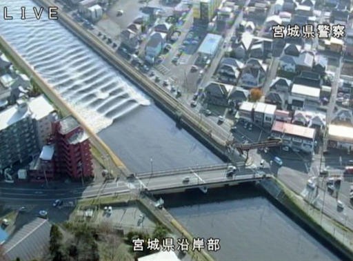 The water flows up river in the Sunaoshi River in Tagajo, Miyagi prefecture, northern Japan, as a tsunami warning is issued following a strong earthquake Tuesday, Nov. 22, 2016. (Miyagi Prefectural Police/Kyodo News via AP/-)
T
hree major disasters in 2018 taught some painful lessons about the challenges of tsunami preparedness and early warning in Indonesia.
In August, a strong earthquake hit Lombok. A subsequent tsunami warning by the Meteorology, Climatology and Geophysics Agency (BMKG) for northern Lombok created panic among residents and visitors in Lombok and on the Gili Islands. The incident revealed that there is still little public understanding about warning procedures and levels of the national tsunami warning system (InaTEWS).
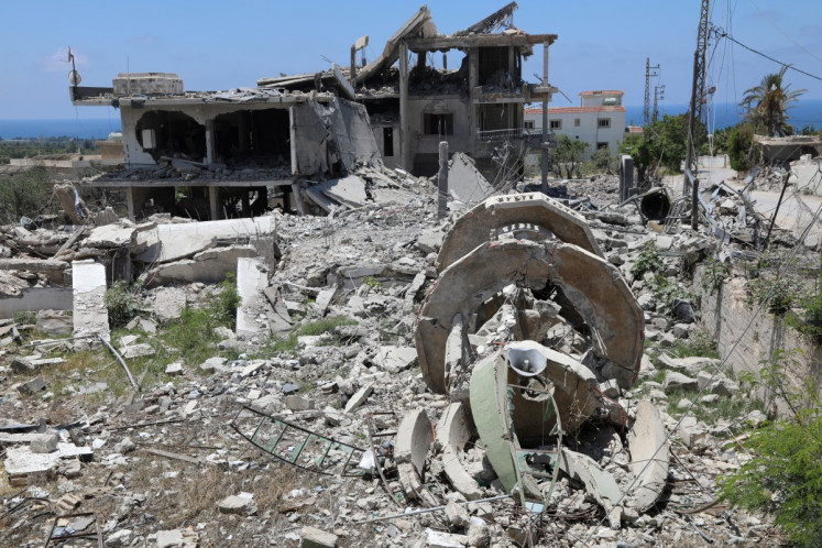
A couple of weeks later, Sulawesi experienced a tsunami, which most likely was triggered by various landslides as a cascading effect of a strong earthquake. The tsunami arrived within a few minutes after the earthquake; too fast to warn the public. Even so, the BMKG was able to send out a warning within five minutes but it did not reach residents in high-risk areas. The warning chain did not work past the last kilometer.
The latest tsunami along the coastlines of the Sunda Strait took nearly everyone by surprise. Obviously, it was triggered by a landslide on Anak Krakatau’s flank when it erupted. There was no mechanism in place to provide a warning.
Does this mean that the Indonesian tsunami early warning system failed? From our point of view, this can hardly be deduced from these recent cases.
First of all, the InaTEWS was developed to detect tsunamis caused directly by strong earthquakes, which account for 90 percent of all tsunamis in Indonesia. Furthermore, it was decided to operate the warning system without buoys for a number of good reasons. Unfortunately, the latter fact has often been misinterpreted by declaring the system broken or non-functional. To our knowledge, no operational tsunami early warning system in the world would have been able to handle the situation Indonesia faced due to the Sulawesi and Krakatau events.
A major problem during such events is the timely detection of a possible tsunami in view of the very short warning times. Timely means a few minutes. In cases of tsunamis being triggered by strong earthquakes, detection is performed by seismic networks on a regional and even global scale as well as GPS observations. This means that the detection of a tsunami threat can be done by land-based technologies from a huge distance within a short time. And this is how the InaTEWS currently works.
The situation is completely different in the case of tsunamis triggered by landslides, either as a secondary effect of an earthquake or volcanic activity. These usually have no strong seismic signatures which could be detected. In order to detect them in time, instrumentation close to the triggering landslide would be needed. To achieve this, a dense network of instrumentation in all regions with potential landslides would be required.
Nowadays, technologies have been developed that can serve such an idea of dense instrument networks to detect landslides or tsunamis generated by landslides. The most promising are fiber-optic cables on the seafloor, which can be used as sensors themselves or as a power supply and information link for attached sensors like pressure sensors, accelerometers, seismometers or other instrumentation to be developed in future. This would be more sustainable and, in the long run, a more economical solution compared to buoy systems, for example.
A possible start for the introduction of such technologies could be the intelligent and wise usage of telecommunication cables. We are aware of plans to set up such an underwater fiber optic cable around Indonesia as part of the new 5G telecommunications system. We therefore propose to examine the usage of such cables for early warning purposes, which are already in the conceptual phase, to implement early warning functionality on the cable system.
This requires the political will in Indonesia and close cooperation between different national institutions and industries. In order to do this, a first step could be to map the most landslide-prone areas (including volcanic hazards) in Indonesia and to identify regions where dense instrumentation would be a priority.
The three events show that early warning needs to be further improved. However, these experiences also show that technology can only be part of the solution. Without effective warning chains and adequate public understanding, improved technology will not have the intended effects.
Further on, preparedness is not only about better warnings. It has a lot to do with risk knowledge and our ability to translate it into realistic and appropriate preparedness strategies. The tsunami threat from the Krakatau volcano is not unknown. It happened in 1883 and it was pointed out as a possibility in a study by a French scientist in 2012. But was it taken up in a broader discussion in society on how to deal with such a risk scenario?
For a society that lives directly in the Ring of Fire, it is essential to promote a more informed discussion about possible risk scenarios, the degree of accepted risk and the necessary strategies to reduce the risks society does not want to take.
Risk reduction and preparedness are the business of everyone. A stronger culture of preparedness is required. People have rightly called for disaster preparedness to be better integrated into school curricula, but what about plans to prepare the schools themselves? It is hard to believe, but Indonesia does not yet oblige schools in tsunami-affected areas to develop their own evacuation plans.
The decision to do this is up to the schools, and it often requires the initiative of an NGO to start emergency planning for the school. And what about the tourism sector? What was the status of tsunami awareness and preparedness along the Banten coast?
One does not always have to reinvent the wheel, there are good examples like the “tsunami ready” initiative of the Bali Hotels Association, which shows how to strengthen tsunami preparedness in the tourism sector in a collective way.
***
Jörn Lauterjung heads the Division Scientific Infrastructures at GFZ Potsdam and was head of the German-Indonesian Tsunami Early Warning System (GITEWS) and Project for Training, Education and Consulting for Tsunami Early Warning System (PROTECTS) from 2005 to 2013. Harald Spahn is a geologist who worked in Indonesia from 2006 to 2013 as team leader for capacity building within the GITEWS and PROTECTS projects.