TheJakartaPost
Please Update your browser
Your browser is out of date, and may not be compatible with our website. A list of the most popular web browsers can be found below.
Just click on the icons to get to the download page.

Popular Reads
Top Results
No results found. Please check your search term and try again
Can't find what you're looking for?
View all search resultsPopular Reads
Top Results
No results found. Please check your search term and try again
Can't find what you're looking for?
View all search resultsMissing fence in Strait of Malacca
On April 9, a video went viral on social media. It shows Indonesian patrol officers in the Strait of Malacca, between Sumatra and the Malaysian Peninsula, reporting they were being chased by a Malaysian vessel. The incident reportedly took place in Indonesian waters following the capture of Malaysian fishermen operating in Indonesian waters by Indonesian patrol officers.
Change text size
Gift Premium Articles
to Anyone
Share the best of The Jakarta Post with friends, family, or colleagues. As a subscriber, you can gift 3 to 5 articles each month that anyone can read—no subscription needed!
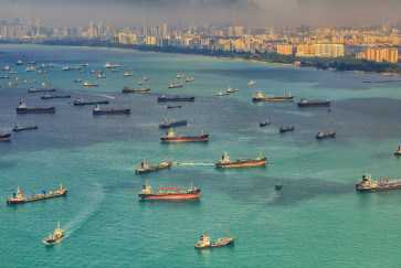
 The Malacca Strait, a narrow 890-kilometer stretch of water between the Malay Peninsula and Sumatra. (Shutterstock/File)
O
n April 9, a video went viral on social media. It shows Indonesian patrol officers in the Strait of Malacca, between Sumatra and the Malaysian Peninsula, reporting they were being chased by a Malaysian vessel. A Malaysian vessel was seen moving next to the vessel from which the video was recorded. The situation seemed tense, and the incident reportedly took place in Indonesian waters following the capture of Malaysian fishermen operating in Indonesian waters by Indonesian patrol officers.
Maritime boundaries between Indonesia and Malaysia, particularly for the exclusive economic zone (EEZ) water column, in the northern part of the Strait of Malacca have yet to be finalized. On the other hand, the division of the seabed, or continental shelf, between the two countries was already settled in 1969. Hence, ownership over the seabed has been made clear, but not that of the water column.
Legally speaking, seabeds, or the continental shelf, and water columns, or EEZs, are two different regimes governed by different provisions in the United Nations Convention on the Law of the Sea (UNCLOS). Often, a seabed has been delimited/divided but not the water column above it. Other situations can be the other way around; for example in the Sulawesi Sea between Indonesia and the Philippines. The two countries agreed on an EEZ water column boundary in May 2014 but they have yet to delimit the continental shelf boundary.
Now, if there is no border dividing waters in the Strait of Malacca, how can one judge if a vessel is on the Indonesian side or the Malaysian side? More specifically, how can one tell that a vessel has committed a border crossing? How can a vessel cross a fence that does not exist?
It is important to know that even though Indonesia and Malaysia have yet to establish an EEZ boundary between them, they have both proposed their own border lines. Each has their own unilateral claim, which is quite a common practice where maritime boundaries are pending. Unsurprisingly, the unilateral claims made by Indonesia and Malaysia are different and the two proposals created a space claimed by both sides. This space is usually referred to as an overlapping claim or a “grey area”.
Interestingly, even though UNCLOS does govern EEZ boundary delimitations between two countries, it never specifically defines what technical methods are to be used to draw such lines between the concerned countries. Article 74 of UNCLOS only prescribes that two countries should work together to achieve an “equitable solution”. The term “equitable” can be wildly interpreted by countries for their own benefit. This, among other reasons, is why the unilateral claims proposed by Indonesia and Malaysia in the Strait of Malacca are so different and generate an overlapping area of approximately 14,300 square kilometers. An illustrative map showing this area is available at bit.ly/PetaMalaka.
Considering several factors, such as the distance of the proposed lines from each coastline/baselines and the maritime areas produced by each claim, it is safe to say that Indonesia’s proposal is closer to the principle of an “equitable solution”. On the other hand, Malaysia’s proposal is apparently more convenient from a practicality perspective since it coincides with the existing seabed boundary set in 1969.