TheJakartaPost
Please Update your browser
Your browser is out of date, and may not be compatible with our website. A list of the most popular web browsers can be found below.
Just click on the icons to get to the download page.

Popular Reads
Top Results
No results found. Please check your search term and try again
Can't find what you're looking for?
View all search resultsPopular Reads
Top Results
No results found. Please check your search term and try again
Can't find what you're looking for?
View all search resultsBiggest exposed fault on earth found in eastern Indonesia
Change text size
Gift Premium Articles
to Anyone
Share the best of The Jakarta Post with friends, family, or colleagues. As a subscriber, you can gift 3 to 5 articles each month that anyone can read—no subscription needed!
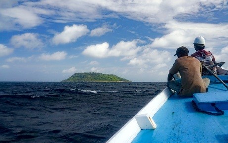 Sailing across the Banda Sea toward the small island of Fadol. (JP/Jonathan Pownall)
G
eologists from the Australian National University (ANU) and Royal Holloway, University of London, have discovered the largest identified exposed fault plane on Earth, namely the Banda Detachment fault in eastern Indonesia, which is believed to have caused the formation of a 7 kilometer-deep abyss beneath the Banda Sea.
According to lead researcher Dr. Jonathan Pownall from ANU, nobody has been able to explain how the abyss became so deep over the past 90 years. The findings will help researchers predict future tsunamis and earthquakes in the area, which is part of the Ring of Fire.
Through an analysis of high-resolution maps of the Banda Sea floor, geologists have deduced that the rocks flooring the seas have been cut by hundreds of straight parallel scars. Hence, the Banda Detachment fault “represents a rip in the ocean floor exposed over 60,000 square kilometers,” the researches said in an article for GeoScienceWorld.

(Read also: Banda, the nutmeg treasure islands)
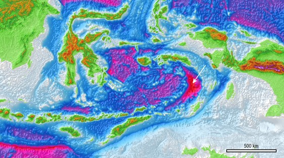 Map of eastern Indonesia, showing the 7 km deep basin of the Weber Deep (in red, indicated by white arrow).(JP/Jonathan Pownall)
Pownall added that the discovery would “help explain how one of the Earth’s deepest sea areas became so deep."
Professor Gordon Lister from the ANU Research School of Earth Science said that this was the first time the fault had been seen and documented by researchers. He further explained, “We had made a good argument for the existence of this fault we named the Banda Detachment based on the bathymetry data and on knowledge of the regional geology,”
Pownall pointed out that knowledge of major faults like the Banda Detachment, which could cause big earthquakes, was “fundamental to being able to properly assess tectonic hazards,” especially in a region of extreme tsunami risk. (mra/kes)
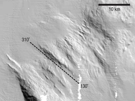 Scars on the ocean floor (image produced from new high-resolution ocean-floor bathymetry data), which were created by the Banda Detachment ripping open and extending the Banda Sea.
(JP/Jonathan Pownall)
Scars on the ocean floor (image produced from new high-resolution ocean-floor bathymetry data), which were created by the Banda Detachment ripping open and extending the Banda Sea.
(JP/Jonathan Pownall)