TheJakartaPost
Please Update your browser
Your browser is out of date, and may not be compatible with our website. A list of the most popular web browsers can be found below.
Just click on the icons to get to the download page.

Popular Reads
Top Results
No results found. Please check your search term and try again
Can't find what you're looking for?
View all search resultsPopular Reads
Top Results
No results found. Please check your search term and try again
Can't find what you're looking for?
View all search resultsNew US tool to help RI predict hot spot locations
As the country enters the dry season, from June to October, a new tool may help the country overcome the annual fires by detecting fire risks daily
Change text size
Gift Premium Articles
to Anyone
Share the best of The Jakarta Post with friends, family, or colleagues. As a subscriber, you can gift 3 to 5 articles each month that anyone can read—no subscription needed!

A
s the country enters the dry season, from June to October, a new tool may help the country overcome the annual fires by detecting fire risks daily.
The tool, developed by a team of experts with Conservation International’s Firecast initiative, the Global Solutions Group and the World Resources Institute (WRI), is based on the US Forest Service’s fire danger rating system.
The tool comes in the form of a fire risk map that calculates the risk of a fire catching and spreading in a given area using satellite-based data on temperature, humidity and rainfall.
These measurements help estimate how wet or dry forest litter (dead tree and plant materials) is —the drier the litter, the higher the risk.
“We’re using data from Terra and Aqua satellites by NASA. And then we aggregate the data into our platform by adding contextual information, such as concessions, land cover, peat or non peat,” WRI Indonesia deputy director Andika Putraditama told The Jakarta Post.
Indonesia, however, already has its own fire danger rating system, says the Environment and Forestry Ministry’s fire mitigation director, Raffles Brotestes Panjaitan.
“We’ve been using FDRS [fire danger rating system] since 2006 with the help of Canada and we also have fire prone map in 10 provinces, which we’ve shared with governors,” he told the Post.
However, Andika said the system was not as robust as the one provided by the WRI.
“We can only see hot spots and their number in each regency. But we wouldn’t be able to know what’s actually happening on the ground because we don’t have contextual information on that,” he said.
Through the tool, a computer model generates a new interactive map every day showing where dry conditions increase fire risk in Indonesia and Malaysia.
“If we can access the data of hot spots and wind direction, which is updated daily, we can know where the fires might spread,” said Andika.
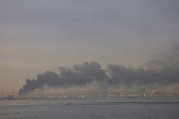
Therefore, the tool can help decisionmakers take action to prevent fires before they start, especially during the current dry season, which will last until October, when fires typically spike and air quality deteriorates.
This year’s dry season is expected to be less dry than last year, which had an abnormally long dry season due to El Niño, a cyclical climate event that warms sea temperatures.
El Niño has now largely ended. Instead, there is a 75 percent chance of La Niña, the cooler inverse of El Niño, which would create wetter-than-average conditions for Indonesia and perhaps a shorter dry season.
So far in 2016, most of Indonesia has been relatively rainy and with few fires, although conditions are growing drier.
The new fire risk data shows that average fire risk is at moderate to low in provinces that saw significant fire outbreaks last year, but beginning to enter high-risk conditions in portions of Riau, Central Kalimantan and West Kalimantan.
Last week, 288 hot spots were detected throughout the country, with North Sumatra having the largest number of hot spots.
As the threat of land and forest fires grows, the government could use the fire risk map to inform the public when fire risk is high.
In the US, fire danger warnings help forest users know whether it is safe to build a campfire or operate certain equipment.
Similar warnings or prohibitions on fires on dry days could help raise awareness.
The government could also coordinate fire response actions when fires occur to prevent spreading based on information from the fire risk map.
“If the WRI has a more up-to-date map, then it is nice to utilize it as well,” Raffles said.