TheJakartaPost
Please Update your browser
Your browser is out of date, and may not be compatible with our website. A list of the most popular web browsers can be found below.
Just click on the icons to get to the download page.

Popular Reads
Top Results
No results found. Please check your search term and try again
Can't find what you're looking for?
View all search resultsPopular Reads
Top Results
No results found. Please check your search term and try again
Can't find what you're looking for?
View all search resultsIndonesia issues map acknowledging lands of indigenous peoples
The map, which has a scale of 1:2,000,000, the first of its kind, consists of around 472,981 ha of forest lands that have been verified by the ministry and are in proper condition to be turned into customary forests.
Change text size
Gift Premium Articles
to Anyone
Share the best of The Jakarta Post with friends, family, or colleagues. As a subscriber, you can gift 3 to 5 articles each month that anyone can read—no subscription needed!
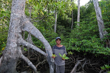
 Guiding hands: Salma Tatua of the Maitefa tribe shows the way to the mangrove forest zone on Babo Island, Teluk Bintuni regency, West Papua. (JP/Jerry Adiguna)
B
ack in 2015, President Joko “Jokowi” Widodo kicked off the ambitious program of social forestry, in which his administration is expected to distribute 12.7 million hectares of forests to be managed by communities throuvarious schemes, including hutan adat (customary forests).
Customary forests are distributed to local neighborhoods that have been established as an indigenous community through a regional bylaw.
However, activists have been lambasting the government for its sluggish progress in recognizing and granting forest tenure to indigenous people despite a historic court ruling around six years ago mandating that the government recognize their tenure rights.
Attempting to answer such criticism, the government launched on Monday a map showing the current and indicative locations of customary forests across the archipelago, the purpose of which is to assist future measures to recognize indigenous people’s tenure rights.
The map, which has a scale of 1:2,000,000, the first of its kind, consists of around 472,981 ha of forest lands that have been verified by the ministry and are in proper condition to be turned into customary forests.
Of the total area, around 384,000 ha was designated as state forest areas, while the other 68,900 ha was nonforest estate. It also includes around 19,150 ha of customary forest area that has been established as of the end of April.
“By declaring lands as indicative locations of customary forests, we assist regional administrations in turning certain areas into such forest,” Environment and Forestry Minister Siti Nurbaya Bakar said on Monday.