TheJakartaPost
Please Update your browser
Your browser is out of date, and may not be compatible with our website. A list of the most popular web browsers can be found below.
Just click on the icons to get to the download page.

Popular Reads
Top Results
No results found. Please check your search term and try again
Can't find what you're looking for?
View all search resultsPopular Reads
Top Results
No results found. Please check your search term and try again
Can't find what you're looking for?
View all search resultsWhy cyclones have hit Southeast Asia so hard
While we cannot say for certain if climate change can be linked to the intense storms that caused devastation in countries across Southern Asia this year, they do indicate the advent of unknown conditions.
Change text size
Gift Premium Articles
to Anyone
Share the best of The Jakarta Post with friends, family, or colleagues. As a subscriber, you can gift 3 to 5 articles each month that anyone can read—no subscription needed!
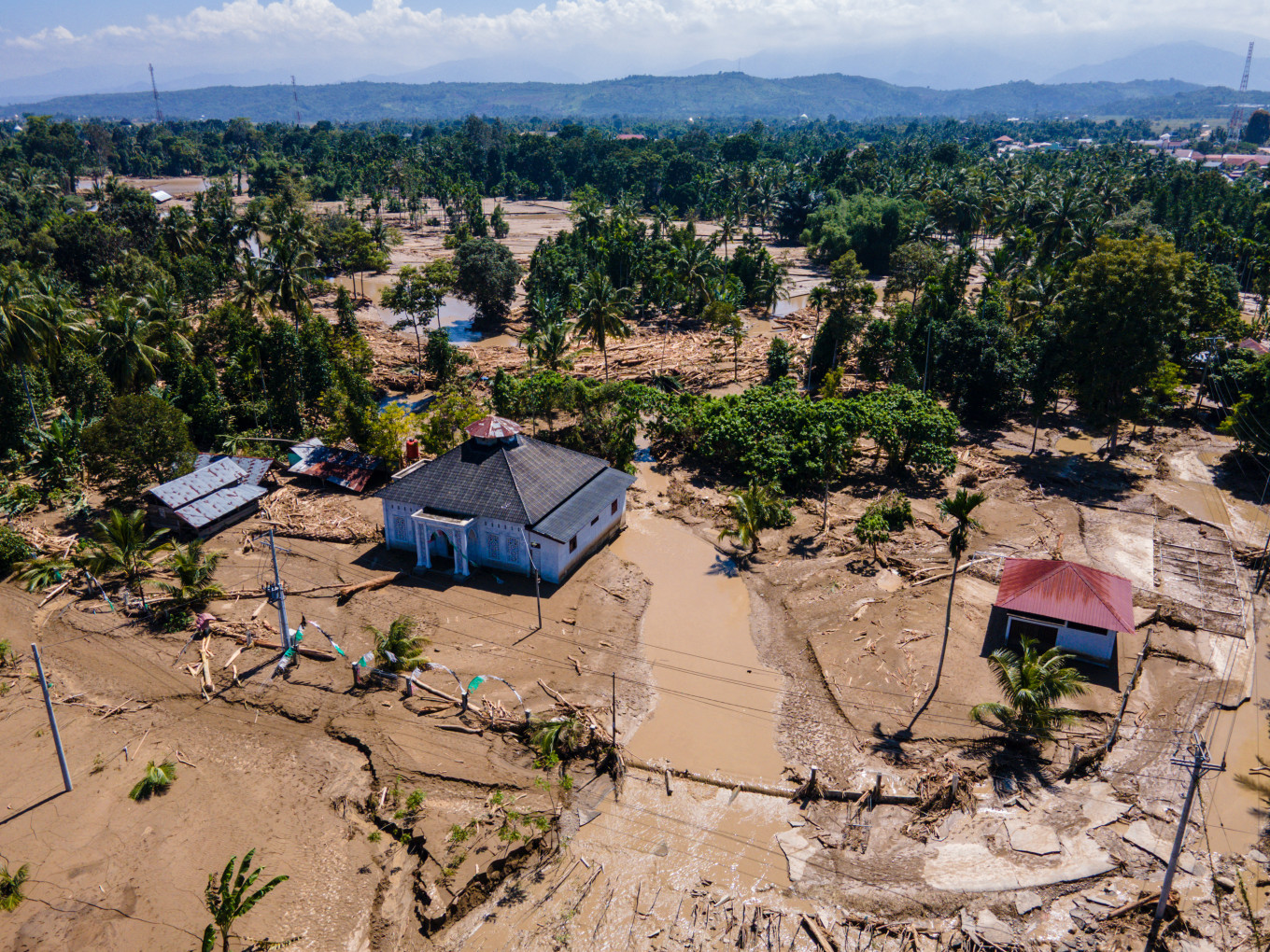 A mosque is surrounded by residual mud and standing water on Nov. 30, 2025, after a flash flood in Meureudu, the administrative seat of Pidie Jaya regency in Aceh. (AFP/Chaideer Mahyuddin)
M
ore than 900 people are dead, thousands more missing and millions affected by a band of cyclones and extreme monsoonal weather across Southern Asia.
Torrential rain has triggered the worst flooding in decades, accompanied by landslides. Indonesia, Sri Lanka, Thailand, Vietnam and Malaysia have been hit hardest. The death toll is likely to rise significantly.
Normally, cyclones don’t form close to the equator. But Cyclone Senyar formed just north of the equator in the Malacca Strait. It triggered lethal flooding in Sumatra and Peninsular Malaysia last week.
It wasn’t alone. Other tropical cyclones formed along a zone of converging trade winds north of the equator. Typhoon Koto caused severe flash floods and landslides in the Philippines before weakening as it neared Vietnam. Tropical Cyclone Ditwah devastated Sri Lanka.
One reason Sumatra was hit by such severe flooding was due to the unusual interaction between Typhoon Koto and Cyclone Senyar, which has now weakened.
The near-simultaneous emergence of these intense storms isn’t unheard of, and equatorial cyclones are rare but known. But the devastation is extraordinary.

Sri Lankan President Anura Kumara Dissanayake described the floods as the “most challenging natural disaster” in the country’s history.
Is there a climate link? We don’t know yet. What we do know is that climate change is projected to trigger fewer cyclones overall but with higher intensity.
Cyclones, typhoons and hurricanes are different names for the same strong, spinning tropical storms. These storms form over large expanses of warm water, but not usually on the equatorial seas. This is because there’s not enough Coriolis force from Earth’s rotation at the equator to spin storms into their classic cyclonic structure.
The closest cyclone to the equator was 2001’s Tropical Storm Vamei, which formed at just 1.4 degrees North. Cyclone Senyar formed at 3.8 degrees North.
While tropical cyclones can form in any month, they’re more common between July and October in the Western North Pacific and North Indian oceans.
Cyclone Senyar and Typhoon Koto formed in the Northwest Pacific Basin, which has the largest, most frequent and most intense tropical cyclones in the world. Several devastating typhoons have hit the Philippines and parts of southern China this year.
One reason these cyclones have caused widespread damage is because they have hit countries where cyclones are rare, such as Indonesia and Malaysia.
Tropical cyclones are often smaller and much less common in the North Indian Ocean, which includes the Bay of Bengal and Arabian Sea, but Cyclone Ditwar tracked directly down Sri Lanka’s eastern coast, magnifying the damage.
As the world’s oceans and atmosphere warm at an accelerating rate due to the rise in greenhouse gases from burning fossil fuels, tropical cyclones are expected to become more intense. This is because cyclones get their energy from warm oceans.
The warmer the ocean, the more fuel for the storm: The warming atmosphere is supercharging the global water cycle and peak rainfall rates are increasing. When more rain falls in a short time, flash flooding becomes more likely.
We can’t immediately say climate change made these storms worse, as it takes time to pinpoint any link.
Many Australians will wonder whether these devastating cyclones across Asia are a warning for northern Australia’s monsoon season.
The wet season started with a bang in northern Australia, after Severe Tropical Cyclone Fina caused damage and disruption across the Top End and Kimberley last week. It was very early for a cyclone in the South Pacific and Indian oceans, as the season runs November to May.
Last week also saw the most damaging spring storms in more than a decade in South East Queensland and northern New South Wales. Giant hail and destructive winds did major damage, costing one insurer an estimated A$350 million (US$230 million).
This doesn’t mean a bad cyclone season is guaranteed. It’s not possible to predict individual tropical cyclone events far in advance. All indicators point to a mixed wet season across the north this year, with below-average rainfall across much of the northwest and average to above-average rainfall across the northeast.
Australia’s Bureau of Meteorology (BOM) has just declared a La Niña event in the Pacific. La Niña typically brings cooler, wetter weather to northern Australia, a stronger monsoon and a higher risk of cyclones. This La Niña is likely to be relatively weak and short-lived, which is why rainfall predictions are largely average.
Across most of the Coral Sea, sea surface temperatures are up to 2 degrees C above normal. This unusual warmth increases the risk of cyclone formation as well as more intense monsoonal rains and flooding in coming months. In the south, there’s increased risk of heat waves and bushfires, with a very hot summer forecast across most of Australia.
The BOM recently ended seasonal cyclone forecasts, as it’s no longer possible to do so reliably. Until now, meteorologists used historic data to reasonably accurately model the total number of cyclones in a season, but the climate is now changing so fast it’s no longer possible to do this.
As rescue attempts continue in many countries in the region, it’s clear we are now entering uncharted territory.
---
The writer is an adjunct professor of environmental geography at Central Queensland University. This article is republished under a Creative Commons license.