TheJakartaPost
Please Update your browser
Your browser is out of date, and may not be compatible with our website. A list of the most popular web browsers can be found below.
Just click on the icons to get to the download page.

Popular Reads
Top Results
No results found. Please check your search term and try again
Can't find what you're looking for?
View all search resultsPopular Reads
Top Results
No results found. Please check your search term and try again
Can't find what you're looking for?
View all search resultsDeforestation turns cyclonic storms into likely recurring tragedies
Extreme rain wasn’t the only cause of Sumatra’s deadly floods. Years of forest loss, eroded soils and weakened watersheds turned a storm into a tragedy, one that could repeat.
Change text size
Gift Premium Articles
to Anyone
Share the best of The Jakarta Post with friends, family, or colleagues. As a subscriber, you can gift 3 to 5 articles each month that anyone can read—no subscription needed!
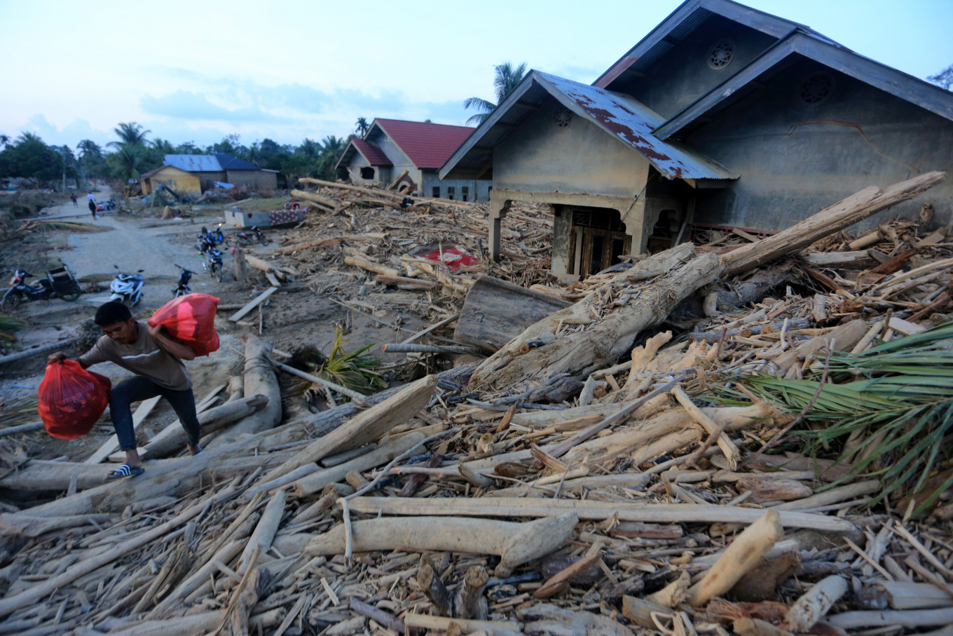 A man walks over a pile of logs and debris next to a damaged home on Dec. 5, 2025, in Geudumbak village, Langkahan district, North Aceh, after a flash flood on Nov. 26 swept them into areas along the Arakundo River Basin. (Antara/Syifa Yulinnas)
C
yclone Senyar hit South and Southeast Asian countries in late November. In Indonesia, the island of Sumatra took the worst hit, especially its northern parts.
The storm set off flash floods and landslides that tore through towns, killed hundreds of people and pushed thousands of families out of their homes. Many houses were submerged to their rooftops or swept away entirely, while rivers turned into sudden, violent torrents.
But this wasn’t just a natural disaster brought on by intense rain. Weather was only part of the story. The real damage occurred when extreme rainfall collided with an already weakened ecosystem. The result was a deadly catastrophe.
When forests are cleared and the land is degraded, the ecosystem loses its natural ability to act as a “sponge”. Rainwater that once slowly seeped into the forest floor now rushes over the land, turning into torrential runoff that crashes into people’s homes.
This is why the recent floods in Sumatra must be understood not only as a hydrometeorological phenomenon but also as a sign of ecosystem collapse: The soil-forest-water cycle is degrading, exacerbated by decades of deforestation and land use change.
Healthy soil works like a sponge. It is rich in organic matter and full of pores and channels created by roots and soil organisms. Well-maintained soil can absorb remarkably large volumes of water.

A forest is not only a collection of trees. It is a hydrological system whose functions extend from underground to the atmosphere. Plant roots create pathways for water to seep into the soil, the canopy slows the fall of rain and leaf litter protects the surface from erosion. Trees absorb water from the soil and release it through transpiration, helping regulate humidity and rainfall patterns.
When forests are cleared for plantations, mining or agricultural expansion, the soil’s capacity to absorb water collapses. The roots that once bound the soil decay. The soil loses its protection. Leaf litter disappears; organic matter declines; the soil becomes compacted, eroded and damaged.
As a result, the landscape loses its ability to absorb water, runoff increases and slopes in hilly and mountainous regions become unstable. Meanwhile, rivers receive large amounts of water in a short time. When they cannot contain it they overflow, triggering deadly floods.
The Batang Toru, a major river, flows through North Sumatra’s South Tapanuli highlands, one of the most biodiverse mountain ranges. Its watershed provides water for irrigation, household use, fisheries and micro hydropower. The surrounding tropical rainforest is the last primary forest block in this region, serving as home for a huge biodiversity and acting as a natural buffer against floods and landslides.
But this resilience is rapidly disappearing. The northern zone of Batang Toru, at an elevation of 300-400 meters, has been open for mining since 2010. Forest clearing for oil palm plantations continued until 2024.
Our latest satellite analysis shows that approximately 1,550 hectares of the forests in the area have lost their vegetation cover, leaving bare soil highly susceptible to erosion in the Batang Toru watershed.
Degraded slopes like these can no longer absorb rainfall or stabilize the watershed. Communities downstream become increasingly vulnerable when extreme storms hit.
In West Sumatra a week earlier, relentless rainfall soaked the provincial capital Padang. Rainfall intensity rose sharply: daily totals increased from 37 millimeters on Nov. 19 to 145 mm on Nov. 27, with total accumulation exceeding 770 mm. The soil finally gave way, unable to hold any more water in its pore network.
An estimated 152 ha of forest have been lost in the upstream areas of the Kuranji and Aie Dingin rivers in Padang. As a result, the entire water cycle has been disrupted: Groundwater recharge declined, surface runoff increased and rivers turned “ferocious”, with surging discharge volumes that triggered flooding. When rain falls, the water is clear. But during floods, it turns brownish yellow or even black, a sign that eroded soil has been carried away by the flow.
Four days after the flash floods, the Batang Kuranji (19.68 kilometers) and Batang Aie Dingin (14.27 km) in Padang remained brownish yellow, flowing rapidly toward Padang Beach.
Communities suffer the consequences, while coastal ecosystems become increasingly choked by sediment.
The four rivers in Padang originate in the Bukit Barisan Mountains, where their exposed soil surfaces easily wash away during heavy rain.
We often see deforestation and soil degradation as local issues, but the scale of the impacts shows that these problems carry national consequences. As extreme rainfall becomes more frequent, every damaged watershed becomes a risk multiplier.
In areas with healthy soils and intact forests, storms can still cause damage, but the ecosystem absorbs part of the impact. In critically degraded areas, the same storm can escalate into a major disaster.
Taking the lesson from Sumatra, this shows that a climate resilience strategy cannot rely solely on levees, dams or emergency responses. We must rebuild the ecological infrastructure that regulates water flow.
Maintaining the soil-forest-water relationship is essential for our safety, now and in the future. Thus, we must protect remaining forests, especially headwater catchments and peatlands; restore degraded soils by increasing organic matter, expanding agroforestry and promoting sustainable farming practices; and include soil health and land cover indicators in flood risk planning.
Ecosystem-based adaptation, from reforestation to planting vegetation along riverbanks, must go hand in hand with engineered solutions. If we only react to disasters without restoring the ecological buffers that prevent them, future floods will be even bigger and more deadly.
Extreme weather will always come. But we can reduce the impacts by restoring forests and improving the condition of the soils beneath our feet, so that the next storm does not have to become the next tragedy.
---
Dian Fiantis is professor of soil science at Andalas University, where Frisa Irawan Ginting is a lecturer. Budiman Minasny is a professor of soil-landscape modeling at The University of Sydney. This article is republished under a Creative Commons license.