TheJakartaPost
Please Update your browser
Your browser is out of date, and may not be compatible with our website. A list of the most popular web browsers can be found below.
Just click on the icons to get to the download page.

Popular Reads
Top Results
No results found. Please check your search term and try again
Can't find what you're looking for?
View all search resultsPopular Reads
Top Results
No results found. Please check your search term and try again
Can't find what you're looking for?
View all search resultsThousands on alert in East Java after Mt. Semeru eruption
The provincial search and rescue agency deployed teams to the worst-affected areas near Mount Semeru to assess damage, with low rainfall giving some reprieve, Tholib Vatelehan, a Basarnas spokesperson, told Reuters.
Change text size
Gift Premium Articles
to Anyone
Share the best of The Jakarta Post with friends, family, or colleagues. As a subscriber, you can gift 3 to 5 articles each month that anyone can read—no subscription needed!
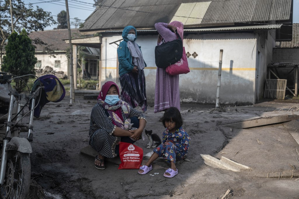 People rest as they salvage their belongings following a volcanic eruption by Mount Semeru at Kajar Kuning village in Lumajang on December 5, 2022. Indonesia's Mount Semeru erupted on December 4 spewing hot ash clouds a mile high and rivers of lava down its side while sparking the evacuation of nearly 2,000 people exactly one year after its last major eruption killed dozens.
(AFP/Juni Kriswanto)
People rest as they salvage their belongings following a volcanic eruption by Mount Semeru at Kajar Kuning village in Lumajang on December 5, 2022. Indonesia's Mount Semeru erupted on December 4 spewing hot ash clouds a mile high and rivers of lava down its side while sparking the evacuation of nearly 2,000 people exactly one year after its last major eruption killed dozens.
(AFP/Juni Kriswanto)
T
housands of residents in East Java were on high alert on Monday after a violent eruption at the island's tallest volcano prompted authorities to impose an 8-kilometer no-go zone and forced evacuations of entire villages.
The provincial search and rescue agency deployed teams to the worst-affected areas near Mount Semeru to assess damage, with low rainfall giving some reprieve, Tholib Vatelehan, a Basarnas spokesperson, told Reuters.
"Yesterday, the rainfall level was high, causing all the material from the top of the mountain to come down. But today, so far, there's no rain, so its relatively safe," he said.
No casualties have been reported and there has not been any immediate disruption to air travel.
The 3,676-metre volcano erupted at 2.46pm local time on Sunday (0746GMT). Footage shot by local residents showed Mt. Semeru spewing a giant cloud of grey ash high above its crater, which later engulfed the mountain and surrounding rice paddy fields, roads and bridges, and turned the sky black.
A video shared by the Environment Ministry on Twitter showed a pyroclastic flow of lava, rocks and hot gases gushing down the mountainside.

People fled the eruption on motorcycles, with almost 2,500 people forced to evacuate, authorities said.
The Volcanology and Geological Hazard Mitigation Agency on Sunday raised the alert level for Mt. Semeru to the highest level. The agency also issued a warning to residents not to approach within 8 km (5 miles) of the summit, or 500 metres of riversides due to risks of lava flows.
Semeru erupted last year killing more than 50 people and displacing thousands more.
The eruption, some 640 km (400 miles) east of the capital, Jakarta, follows a series of earthquakes in the west of Java, including one last month that killed more than 300 people.
One resident described the panic when the ash clouds descended on their village.
"It was dark, I could not see anything. It was raining water and ash," the person, who did not want to be named, told AFP.
"I didn't know where to take shelter. I had to flee."
"Hot avalanches" triggered by piles of lava at the top flooded down the 3,676-metre (12,060 feet) mountain, said Abdul Muhari, a spokesperson for National Disaster Mitigation Agency (BNPB).
A spokesperson for Indonesia's Volcanology and Geological Disaster Mitigation Centre (PVMBG) told broadcaster Kompas TV that the higher alert level meant local villages were in danger.
However, no casualties or injuries were reported on Sunday after the PVMBG warned nearby residents not to travel within eight kilometres (five miles) of the crater.
The geological agency said that by evening Semeru was "still in the eruption phase" though the size of the ash clouds was decreasing.
"Overall the activity is still very high," it said in a statement.
An archipelago of 270 million that sits along the Pacific Ring of Fire, Indonesia is one of the most disaster-prone nations on earth.
With 142 volcanoes, Indonesia has the largest population globally living in close range to a volcano, including 8.6 million within 10km (6.2 miles).