TheJakartaPost
Please Update your browser
Your browser is out of date, and may not be compatible with our website. A list of the most popular web browsers can be found below.
Just click on the icons to get to the download page.

Popular Reads
Top Results
No results found. Please check your search term and try again
Can't find what you're looking for?
View all search resultsPopular Reads
Top Results
No results found. Please check your search term and try again
Can't find what you're looking for?
View all search results10 deadly earthquakes between Aceh and Lombok
In the past 13 years, the archipelago has seen about 30,000 earthquakes of 2.5-magnitude and above. Most are not deadly, but here are 10 of the deadliest from 2005 to 2018.
Change text size
Gift Premium Articles
to Anyone
Share the best of The Jakarta Post with friends, family, or colleagues. As a subscriber, you can gift 3 to 5 articles each month that anyone can read—no subscription needed!
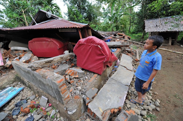
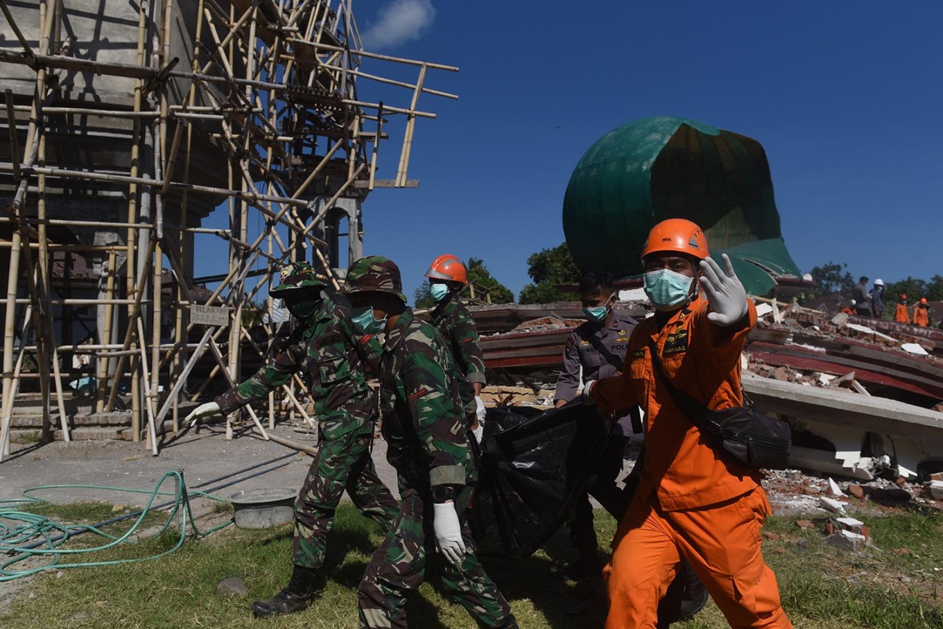 Search and rescue team members remove a body from under the debris of a mosque in Tanjung district, North Lombok regency in West Nusa Tenggara, on Aug. 7. The government recorded as of Aug. 7 at least 105 dead in the earthquake . (Antara/Zabur Karuru)
T
he Aceh earthquake and tsunami in 2004 was one of the deadliest natural disasters in the world so far and a wakeup call for Indonesia to prepare for more earthquakes and volcanic eruptions as the country is located on the Pacific Ring of Fire. Thirteen years later, double earthquakes on July 29 and Aug. 5 struck Lombok Island in West Nusa Tenggara, killing at least 17 the first time and 105 the second time.
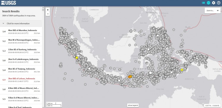
The Earth is constantly moving and according to US Geological Survey search tool, the Indonesian archipelago saw more than 30,000 earthquakes, 2.5-magnitude and above, from Jan. 1, 2005 to Aug. 7 this year. About 10 percent of the quakes, or over 3,600, were 5-magnitude and above. People did not feel most of them and certainly only a few of them were deadly.
Here is a list of the deadliest, with a death of toll more than 10:
March 28, 2005: 8.7 M in Nias, North Sumatra, and Simeulue, Aceh
An earthquake measuring at 8.7 on the Richter scale hit North Sumatra and Aceh, but did not cause a tsunami despite its magnitude. The tremors were felt in Singapore. By late April, the official death toll reached 839, of which 682 were residents of Nias regency. Experts said the earthquake was triggered by the Dec. 26, 2004 quake.
May 27, 2006: 5.9 M scale in Yogyakarta
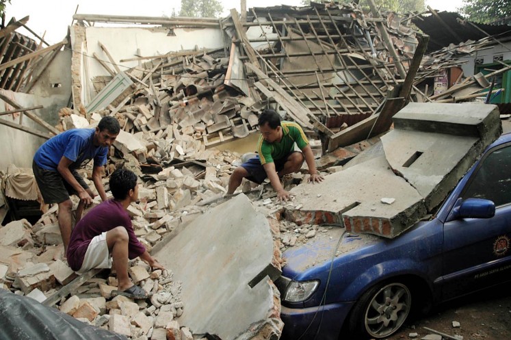
An early morning earthquake measuring 5.9 on the Richter scale shook Yogyakarta. The 5.9 reading was provided by the Meteorology and Geophysics Agency (BMG), while other institutions measured the quake at 6.2. The confirmed death toll passed 4,600, with 200,000 people thought to have been left homeless by the quake. The government declared a state of emergency, which ended on June 30.
July 17, 2006: 6.8 M in Pangandaran, West Java, with accompanying tsunami
A series of earthquakes, the strongest measuring 6.8 on the Richter scale -- the U.S. Geological Survey put it at 7.2 -- triggered a tsunami, with waves reaching as high as 4 meters along parts of the southern coast of Java. The death toll reached 341 and at least 229 people were reported missing, and more than 40,000 people were displaced.
March 6, 2007: 4.9 M and 5.8 M in West Sumatra
Double earthquakes with magnitudes of 4.9 and 5.8 on the Richter scale hit West Sumatra, killing at least 66 people. In addition, 462 people were severely injured and 364 slightly injured. The disaster damaged 43,719 houses, of which 12,948 were heavily damaged. A state of emergency was declared, lasting almost two months.
Sept. 12, 2007: 7.9 M in Bengkulu and Padang, Sumatra Island, with tsunami warning
A powerful earthquake measuring 7.9 on the Richter scale occurred off the west coast of Sumatra Island. The earthquake resulted in an official tsunami warning, which was lifted two hours later. The undersea earthquake occurred 100 kilometers off the southwest of Bengkulu city at a depth of 15 km. The death toll reached 19, with at least 100 others severely injured.
Sept. 2, 2009: 7.3 M in West Java, with tsunami warning
A 7.3-magnitude quake struck at 2:55 p.m., followed by a tsunami warning that was quickly lifted. The quake was felt in Jakarta, 190 km from the epicenter, which was southwest of Tasikmalaya, West Java. Seven days after the quake, the death toll rose to 79 and more than 1,250 people were injured and 210,000 displaced.
Sept. 30, 2009: 7.6 M in Padang, West Sumatra, with tsunami warning
A 7.6-magnitude quake rattled the city of Padang, West Sumatra. Tremors were felt in Medan, Pekanbaru, Jambi, Bengkulu and other areas across Sumatra Island, as well as in Singapore and Malaysia. A tsunami warning for countries around the Indian Ocean was issued after the earthquake, but was lifted an hour and a half later. The tragedy claimed more than 1,000 lives, forcing the government to declare a two-month-long state of emergency.
The US Geological Survey said the quake had a preliminary magnitude of 7.9, and struck 50 km off the coast of Sumatra. However, the Meteorology and Geophysics Agency (BMKG) in Medan put the quake's magnitude at 7.6, with the epicenter 71 km under the sea off Pariaman, 70 km from Padang.
Oct. 25, 2010: 7.8 M in Mentawai Islands, with tsunami
An earthquake-triggered tsunami swept through the Mentawai Islands in West Sumatra after a tsunami warning issued following the 7.2-magnitude quake was lifted. The waves were up to 3 meters in height and reached 600 meters into the islands, washing away hundreds of homes. As of Oct. 30, the death toll reached more than 413, with 163 missing. The disaster also left 4,000 people homeless.
Read also: Aceh earthquake's aftermath
July 2, 2013: 6.2 M in Bireuen, Aceh
A 6.2-magnitude earthquake struck Aceh on July 2, 2013. The quake caused vast damage as a result of its shallow depth at only 13 km. According to the National Disaster Mitigation Agency (BNPB), the death toll reached 35, while 276 were injured.
Dec. 7, 2016: 6.4 M in Pidie Jaya, Aceh
A 6.4 on the Richter scale earthquake occurred at 5:03 a.m. local time, 106 km southeast of Banda Aceh at a depth of 10 km. With at least 102 fatalities and 3,267 people displaced, this has been the deadliest earthquake in Aceh since 2006.