TheJakartaPost
Please Update your browser
Your browser is out of date, and may not be compatible with our website. A list of the most popular web browsers can be found below.
Just click on the icons to get to the download page.

Popular Reads
Top Results
No results found. Please check your search term and try again
Can't find what you're looking for?
View all search resultsPopular Reads
Top Results
No results found. Please check your search term and try again
Can't find what you're looking for?
View all search resultsFirst rain after dry days could cause tornadoes at this time of year: BMKG
A tornado is usually preceded by a short duration of heavy rain with lightning and strong wind. In Indonesia, it commonly occurs during seasonal transition.
Change text size
Gift Premium Articles
to Anyone
Share the best of The Jakarta Post with friends, family, or colleagues. As a subscriber, you can gift 3 to 5 articles each month that anyone can read—no subscription needed!
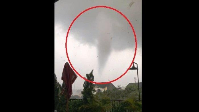 A still shows the tornado that hit Bogor, West Java, on Dec. 6, claiming one life and damaging hundreds of houses and several vehicles.
(tribunnewsbogor.com/Istimewa)
A still shows the tornado that hit Bogor, West Java, on Dec. 6, claiming one life and damaging hundreds of houses and several vehicles.
(tribunnewsbogor.com/Istimewa)
T
he Meteorology, Climatology and Geophysics Agency (BMKG) has explained the tornado that hit the municipality of Bogor in West Java, killing a resident, toppling 20 trees and damaging 848 houses and five vehicles.
“A tornado is a natural and commonly occurring weather phenomenon,” BMKG spokesman Hary Djatmiko explained on Friday.
A tornado is usually preceded by a short duration of heavy rain with lightning and strong wind. In Indonesia, it commonly occurs during seasonal transition, either from the dry season to the rainy season or vice versa, as well as during the rainy season when the morning was sunny and hot, Hary said in a written statement made available to The Jakarta Post.
A tornado, which always moves in a straight line, tends to occur in the afternoon or early evening.
It lasts less than 10 minutes and affects a stretch of less than 10 kilometers.
Hary said a tornado could only be predicted up to one hour in advance and typically moved at a speed of up to 45 km per hour.
“It is less likely to recur in the same location,” he added.
Heavy rain with lightning and strong wind could be observed before a tornado, when the air would feel stiflingly hot from midnight until morning.
Starting at 10 a.m. in the morning, the puffy-looking cumulus clouds would form, and one type of this cloud featured grey edges and tended to soar like a cauliflower.
Before a tornado, that cloud would turn into blackish grey, growing into a dense and towering vertical cloud of the cumulonimbus type.
A tornado could only develop from cumulonimbus clouds. However, not all cumulonimbus clouds would generate a tornado.
“If within one to three days there was no rain during the transition season, the first rain might potentially be heavy rain, followed by strong wind, which could result in a tornado," Hary said. (sau)