TheJakartaPost
Please Update your browser
Your browser is out of date, and may not be compatible with our website. A list of the most popular web browsers can be found below.
Just click on the icons to get to the download page.

Popular Reads
Top Results
No results found. Please check your search term and try again
Can't find what you're looking for?
View all search resultsPopular Reads
Top Results
No results found. Please check your search term and try again
Can't find what you're looking for?
View all search resultsWarm oceans seem to be turning even ‘weak’ cyclones deadly
Cyclones Ditwah and Senyar show we must prepare for storms that are weak in wind but extreme in rain.
Change text size
Gift Premium Articles
to Anyone
Share the best of The Jakarta Post with friends, family, or colleagues. As a subscriber, you can gift 3 to 5 articles each month that anyone can read—no subscription needed!
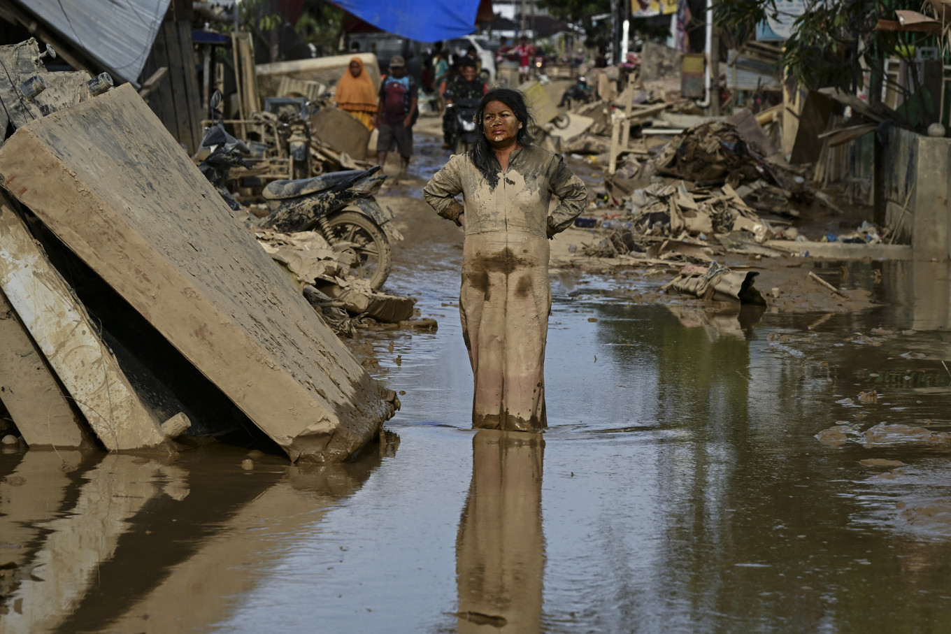 A woman covered in mud stands on a street filled with mud after a flash flood hit the area in Aceh Tamiang, Aceh, on Dec. 6, 2025. (AFP/YT Hariono)
T
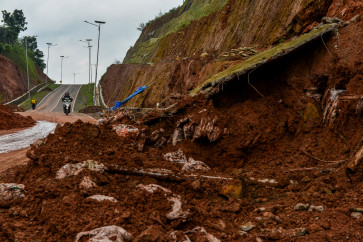
he final week of November was devastating for several South Asian countries. Communities in Sri Lanka, Indonesia and Thailand were inundated as Cyclones Ditwah and Senyar unleashed days of relentless rain. Millions were affected, more than 1,500 people lost their lives, hundreds are still missing and damage ran into multiple millions of dollars. Sri Lanka’s president even described it as the most challenging natural disaster the island has ever seen.
When disasters like this happen, the blame often falls on a failure in early warnings or poor preparedness. This was the case with major floods in Kerala, south India, in 2018, which devastated my hometown.
But this time, the forecasts were largely accurate; the authorities knew the storms were coming, yet the devastation was still immense.
So, if the forecasts were good enough, why were the impacts still so severe?
One emerging explanation is that these storms were not dangerous because of their winds, but because they produced unusually intense rainfall.
Consider Cyclone Ditwah. Its peak winds were around 75 kilometers per hour. That is windy, but nothing special. In the United Kingdom, it would be classified merely as a “gale” rather than a “storm”. It was far weaker than the 220 km/h winds of the powerful 1978 cyclone that also struck Sri Lanka. Yet Ditwah still caused massive devastation.

What explains this apparent contradiction? It is too early to say definitively, but climate change is likely a part of the story. Even when storms are not especially strong in wind terms, the amount of rain they carry is increasing.
A well established meteorological rule helps explain why. For every degree of global warming, the atmosphere can hold about 7 percent more moisture.
As the planet warms, the air above us becomes a larger reservoir, waiting to dump more water on us. When storms form, they can tap into this expanded supply, often in extremely short bursts. Even if wind speeds are modest, the rainfall alone can be catastrophic.
Warming oceans play an even more powerful role, as cyclones draw their energy from warm ocean waters. Satellite data from late November show just how warm the eastern Indian Ocean was, with large areas more than 1 degree Celsius above normal during Ditwah and Senyar.
Such warm anomalies are no longer unusual. The oceans have absorbed more than 90 percent of the excess heat trapped by greenhouse gases, and long-term observations show a clear upward trend in ocean temperatures.
That does not necessarily mean cyclones are becoming more frequent, their formation still depends on other ingredients, such as low wind shear (small differences in wind speed and direction with height) and the right atmospheric structure.
What warmer oceans do change, however, is the amount of energy available to any storm that does manage to form. When the ocean is warmer, cyclones have more fuel and evaporation increases, loading the atmosphere with moisture that can fall as intense rain once a storm develops. Even weak cyclones can therefore hold exceptional amounts of rain.
The winds near the surface help this process along. As they move across the ocean, they sweep away the moisture-filled air just above the water and replace it with drier air, allowing evaporation to continue. Put together, warmer oceans, higher evaporation and an atmosphere that can store more moisture, these factors can significantly intensify the rainfall associated with cyclones.
Local geography amplified these effects. Both Ditwah and Senyar formed unusually close to land and traveled along the coastline for an extended period. This meant they stayed over warm waters long enough to continuously draw moisture, but remained close enough to land to dump that moisture as intense rainfall almost immediately.
Cyclone Ditwah, in particular, moved slowly as it approached Sri Lanka. Slow-moving storms can be especially dangerous as they repeatedly dump rain over the same area. Even if winds are weak, this combination of warm seas, coastal proximity and slow forward speed can be devastating.
These storms suggest that climate change, especially ocean warming, is reshaping the risks posed by cyclones. The most dangerous storms may no longer simply be the ones with the strongest winds, but also the ones with the most moisture.
Forecasting systems, including new AI-powered weather models, are getting better at predicting cyclone tracks and wind speeds. Yet rainfall-driven flooding remains far harder to forecast. As oceans continue to warm, governments and disaster agencies will need to prepare for storms that may be weak in wind but extreme in rain.
These insights are based on preliminary analysis and emerging scientific understanding. More detailed peer-reviewed studies will be needed to pinpoint exactly why Ditwah and Senyar produced such extreme rainfall. But the pattern that is emerging, weak cyclones delivering outsized floods in a warming world, must not be ignored.
---
The writer is a PhD candidate in oceanography at University of Southampton, in the United Kingdom. This article is republished under a Creative Commons license.