TheJakartaPost
Please Update your browser
Your browser is out of date, and may not be compatible with our website. A list of the most popular web browsers can be found below.
Just click on the icons to get to the download page.

Popular Reads
Top Results
No results found. Please check your search term and try again
Can't find what you're looking for?
View all search resultsPopular Reads
Top Results
No results found. Please check your search term and try again
Can't find what you're looking for?
View all search resultsBali earthquake kills three, injures dozens
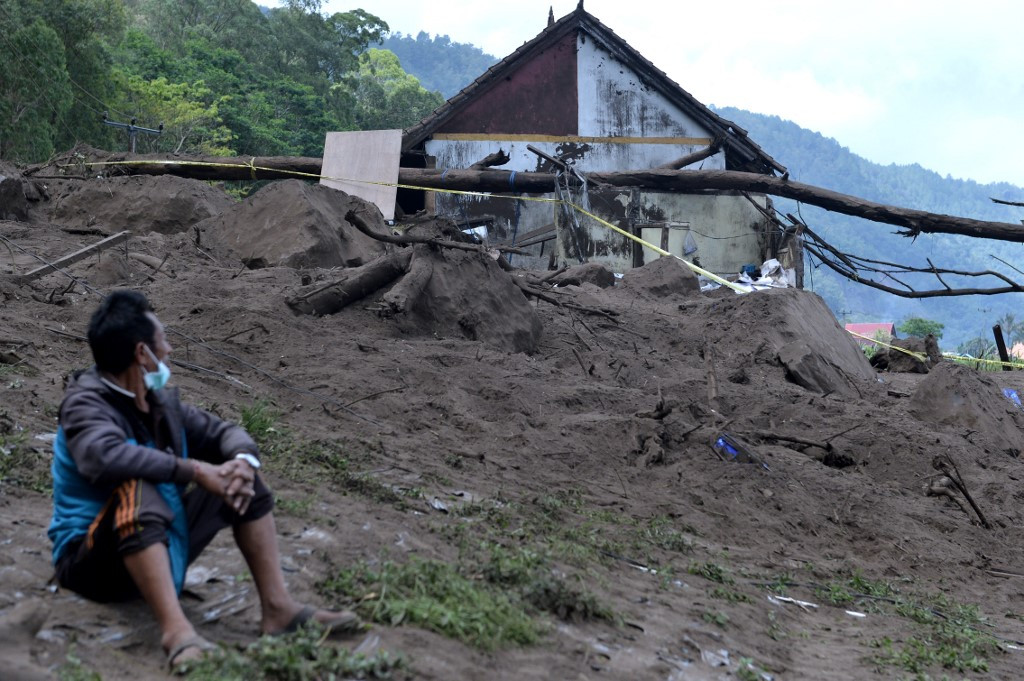
By Sunday, more than 300 houses and one education center were found to have been heavily damaged in Karangasem and Bangli, as well as at least 100 Balinese Hindu temples.
Change text size
Gift Premium Articles
to Anyone
Share the best of The Jakarta Post with friends, family, or colleagues. As a subscriber, you can gift 3 to 5 articles each month that anyone can read—no subscription needed!
At least three people were killed and dozens were injured in an earthquake that struck Bali on Saturday morning.
The 4.8-magnitude quake was centered in northwest Karangasem at a depth of 10 kilometers, which is relatively shallow, a factor that experts say contributes to the potential damage. The effects were felt in Karangasem, Denpasar and on the neighboring island of Lombok, AFP reported.
"The quake was felt strongly for five seconds," National Disaster Mitigation Agency (BNPB) spokesperson Abdul Muhari said, as quoted by AFP. "People were panicking and ran from their houses when the quake hit."
Landslides triggered by the quake buried houses in Trunyan village in Kintamani district, Bangli regency, and killed two people, including an 8-year-old child, Bali Search and Rescue Agency head Gede Darmada said in a statement received by The Jakarta Post on Saturday. A third, a 3-year-old girl, was killed by falling debris in the neighboring Karangasem regency.
Bali Disaster Mitigation Agency head Made Rentin said in a press release that the rescue team had evacuated people across Lake Batur on boats, as the road to the stricken Trunyan village, located on the eastern shore of the lake, had been cut off by landslides.
The team saved four people who were buried under the rubble. They were rushed to the nearest community health center (Puskesmas).
In the neighboring Karangasem regency, the rescue team was, as of Saturday, still trying to evacuate one victim buried under debris. The team took eight people who had suffered minor injuries and five with serious injuries to the nearest Puskesmas and the Karangasem Regional Hospital.
By Sunday, more than 300 houses and one education center were found to have been heavily damaged in Karangasem and Bangli, as well as at least 100 Balinese Hindu temples. Authorities are continuing to survey the damage in the two affected regencies.
On Saturday evening, the Meteorology, Climatology and Geophysics Agency (BMKG) recorded two aftershocks with magnitudes of 3.8 and 2.7 in Karangasem.
The BNPB’s online disaster map, InaRISK, showed that nine regions of the island had a moderate to high risk of earthquakes, including Kintamani in Bangli, Rendang in Karangasem and Tejakula in Buleleng. Meanwhile, the areas at high risk of landslides were Trunyan, Rendang and Tejakula.
There was no significant damage in other parts of Bali, AFP reported. The island officially reopened to international tourists on Thursday after 18 months of pandemic restrictions, but visitors are only expected to start arriving later this month. (jan)