TheJakartaPost
Please Update your browser
Your browser is out of date, and may not be compatible with our website. A list of the most popular web browsers can be found below.
Just click on the icons to get to the download page.

Popular Reads
Top Results
No results found. Please check your search term and try again
Can't find what you're looking for?
View all search resultsPopular Reads
Top Results
No results found. Please check your search term and try again
Can't find what you're looking for?
View all search resultsRapid response key to flood prevention
Currently, the flood control and early warning system in Jakarta is ineffective.
Change text size
Gift Premium Articles
to Anyone
Share the best of The Jakarta Post with friends, family, or colleagues. As a subscriber, you can gift 3 to 5 articles each month that anyone can read—no subscription needed!
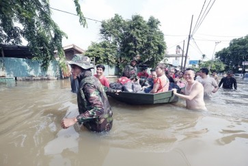
 In the same boat: Soldiers help evacuate residents from the flood-hit Bojong Indah residential area in West Jakarta earlier this month. Cooperation between the central government and local administrations key to solving the annual disaster. (JP/Donny Fernando)
E
ntering the New Year, the capital city was severely flooded. The Meteorology, Climatology, and Geophysics Agency (BMKG) reported heavy to very heavy intensity rainfall spread across Greater Jakarta, concentrated in the eastern part of Jakarta with the highest level recorded in the Halim Perdanakusuma area.
It was the highest recorded rainfall since 1866. The BMKG reported that the atmospheric phenomena of the strengthening Asian monsoon flow and the location of the intertropical convergence zone, a low-pressure area located precisely over the north of Java, had caused the heavy downpour of that scale on the northern coast of Java.
This circumstance was observed a few days earlier on the north coast of Java, such as flooding that occurred at the Cikopo-Palimanan (Cipali) toll road in Indramayu. Toward the New Year, this low pressure was stronger in Jakarta, especially in the eastern part of the capital city.
Meanwhile, Australia was experiencing an extreme summer, resulting in very low air pressure over the continent. Hence, the westerly monsoon system that blew from Asia to Australia, carrying water vapor as it passed through the South China Sea and the Indian Ocean, became stronger due to pressure differences. The ocean turned warmer, causing evaporation that created a lot of water vapor.
Arriving in Java, this water vapor condensed rapidly upon reaching the high mountains. This continued to occur so that it generated massive and towering cumulonimbus clouds spreading in the north, as captured by the satellite imagery, which caused strong winds and heavy rains accompanied by lightning in the north of Java and western Indonesia.
Why was the rain so heavy in East Jakarta? The eastern parts of Jakarta, Bekasi and Cikarang, are home to the industry and massive infrastructure development, resulting in high temperatures and low-pressure areas. Cumulonimbus clouds moved to these areas, and high-intensity rain poured over East Jakarta.
In addition to the extreme weather, the poor drainage system played a part in the flooding. Tons of waste piling up the drainage canals should have been removed through proper maintenance. Due to the poor drainage, the rain created puddles and flooding in Jakarta.