TheJakartaPost
Please Update your browser
Your browser is out of date, and may not be compatible with our website. A list of the most popular web browsers can be found below.
Just click on the icons to get to the download page.

Popular Reads
Top Results
No results found. Please check your search term and try again
Can't find what you're looking for?
View all search resultsPopular Reads
Top Results
No results found. Please check your search term and try again
Can't find what you're looking for?
View all search resultsTwo islands vanish, four more may sink soon, says Walhi
Two small islands in South Sumatra have disappeared as a result of rising sea levels driven by climate change, while four other islands are already on the brink of vanishing, the Indonesian Forum for the Environment (Walhi) has claimed
Change text size
Gift Premium Articles
to Anyone
Share the best of The Jakarta Post with friends, family, or colleagues. As a subscriber, you can gift 3 to 5 articles each month that anyone can read—no subscription needed!

T
wo small islands in South Sumatra have disappeared as a result of rising sea levels driven by climate change, while four other islands are already on the brink of vanishing, the Indonesian Forum for the Environment (Walhi) has claimed.
The province’s Betet Island and Gundul Island — which technically fell under the administration of Banyuasin regency — have submerged, currently sitting 1 meter and 3 m below sea level, respectively, according to Walhi data.
“These islands were uninhabited. One of the islands, Betet, is a part of Berbak-Sembilang National Park,” Walhi South Sumatra executive director Hairul Sobri said on Tuesday.
Should there be no significant efforts to address the ever-rising oceans, four other islands in the area with elevations of less than 4 m above sea level could follow suit and disappear sooner or later, Hairul said.
The four are Burung Island, the elevation of which is currently at sea level; Kalong Island and Salah Namo Island, both of which are currently 2 meters above sea level; and Kramat Island, which is 3 m above sea level.
According to Walhi, there are currently 23 small islands located off the eastern coast of South Sumatra’s Banyuasin. Some of the islands are uninhabited, while some — including Salah Namo Island — have people living on them.
Climate change-driven rising sea levels, which come with further warming of the earth, particularly threaten archipelagic countries like Indonesia, where millions of people currently live in low-lying coastal areas spread across some 17,000 islands.
Syahrul, head of the neighborhood unit in Salah Namo Island, said that they already knew that the rising seas could submerge their island.
People who lived in the island have moved their houses tens of meters away from their original place where their houses were first built, he said.
Syahrul said most residents moved to the island in 1970 to have a better life by planting rice and becoming fishermen. Back in 1990 there were large fields in front of people’s houses where they could exercise and children could play together, but things are different now.
“There is no field in front of our houses. Many of the people have also moved from here,” he said.
The head of Berbak-Sembilang National Park Area II, Affan Absori, confirmed separately that Betet Island had gone underwater and that the island had experienced sinking for some time.
Berbak-Sembilang National Park, which was declared a world biosphere reserve in 2018 by UNESCO, is home to mangrove areas as well as being rich flora and fauna, including the Sumatran tiger and kingfisher birds.
“It has sunk because the seal level has risen and because of the tsunami. But there is no significant disruption for the animals [in the national park],” Affan told The Jakarta Post on Wednesday.
According to Walhi, a tropical country like Indonesia is more vulnerable to the effect of global warming, especially in South Sumatra where people depended a lot on coal, oil and natural gas, thus contributing to emissions of greenhouse gases.
Other factors that have caused the sinking include dependence on chemical fertilizers in the agricultural sector, which causes land subsidence and drainage basin damage, as well as excessive groundwater extraction for industry, Hairul said.
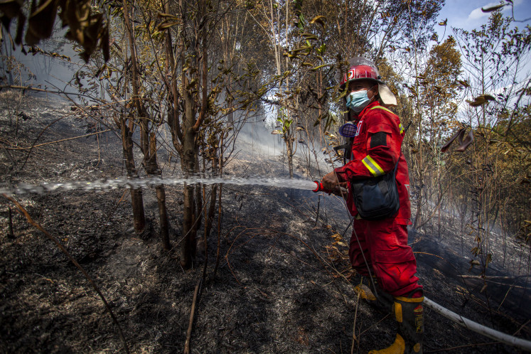
Although South Sumatra has 1.2 million hectares of peatland —which functions as a natural carbon sink and absorbs CO2 from the atmosphere — amounting to some 15 percent of land area, development activities, land conversion and forest fires have caused the peatlands to dry up and become damaged.
South Sumatra Disaster Mitigation Agency (BPBD) recorded that of the 361,889-ha area burned by land and forest fires in 2019, 60 percent comprised peat ecosystems. (hol)