TheJakartaPost
Please Update your browser
Your browser is out of date, and may not be compatible with our website. A list of the most popular web browsers can be found below.
Just click on the icons to get to the download page.

Popular Reads
Top Results
No results found. Please check your search term and try again
Can't find what you're looking for?
View all search resultsPopular Reads
Top Results
No results found. Please check your search term and try again
Can't find what you're looking for?
View all search resultsLand reform: Toward sustainable land management
The next government needs to prioritize spatial planning and land management reform to reflect the realities on the ground, by transferring the current forestry ministry's land management authorities under the agrarian affairs ministry as the sole administrative body for spatial planning, including land use and tenure.
Change text size
Gift Premium Articles
to Anyone
Share the best of The Jakarta Post with friends, family, or colleagues. As a subscriber, you can gift 3 to 5 articles each month that anyone can read—no subscription needed!
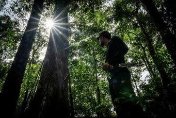
 Shady canopy: A resident of Belangian village stands on Aug. 21, 2024 next to a tall benuang laki (Duabanga moluccana blume), a native evergreen species, in the Kahung tropical rainforest of Banjar regency, South Kalimantan. (Antara/Bayu Pratama S)
R
egulations on spatial planning and land management should be included among the top reform priorities in the cabinet president-elect Prabowo Subianto will form after he is inaugurated on 0ct. 20. This is because these two functions are directly related to land, including inland water, marine areas, airspace and subterranean resources, all of which are Indonesia’s natural assets.
Without judicious spatial planning, the drive for economic development could come at the cost of environmental sustainability. Indonesia must balance the use of its land for economic, social and cultural purposes with the need for conservation and climate change mitigation.
According to Statistics Indonesia (BPS), the country has a land area of 188 million hectares that is divided into two administrative designations: forest area and area for other uses (APL).
APL refers to land used for purposes other than forest and is seen as production zones. This classification has not changed, despite discrepancies with current land use and land cover realities, creating ambiguity and uncertainty in land administration.
The Environment and Forestry Ministry reports that 120.3 million hectares, or 64 percent of Indonesia’s total landmass, are classified as state forest area and fall under its jurisdiction. However, based on land cover analysis, 31.8 million ha, or 26.4 percent of the designated state forest area, no longer fulfill the definition of forests due to degraded land cover.
In reality, these areas have low carbon stocks and include production land cultivated by communities for agriculture, grasslands, transmigration programs, rice fields, settlements and public infrastructure, such as airports and seaports.

On the other hand, the ministry’s data also show that the Agrarian Affairs and Spatial Planning Ministry/National Land Agency (BPN) regulates and manages 67.7 million ha, or 36 percent of the total landmass designated as production land (AP). However, around 7 million ha of APL have forest cover that ecologically meets the terminology and criteria for their classification as a forest area.