TheJakartaPost
Please Update your browser
Your browser is out of date, and may not be compatible with our website. A list of the most popular web browsers can be found below.
Just click on the icons to get to the download page.

Popular Reads
Top Results
No results found. Please check your search term and try again
Can't find what you're looking for?
View all search resultsPopular Reads
Top Results
No results found. Please check your search term and try again
Can't find what you're looking for?
View all search resultsSuper El Niño? Prepare, but do not panic yet
Twin cyclones helped trigger massive ocean warming in the Pacific. But whether that leads to a strong El Niño is still uncertain.
Change text size
Gift Premium Articles
to Anyone
Share the best of The Jakarta Post with friends, family, or colleagues. As a subscriber, you can gift 3 to 5 articles each month that anyone can read—no subscription needed!
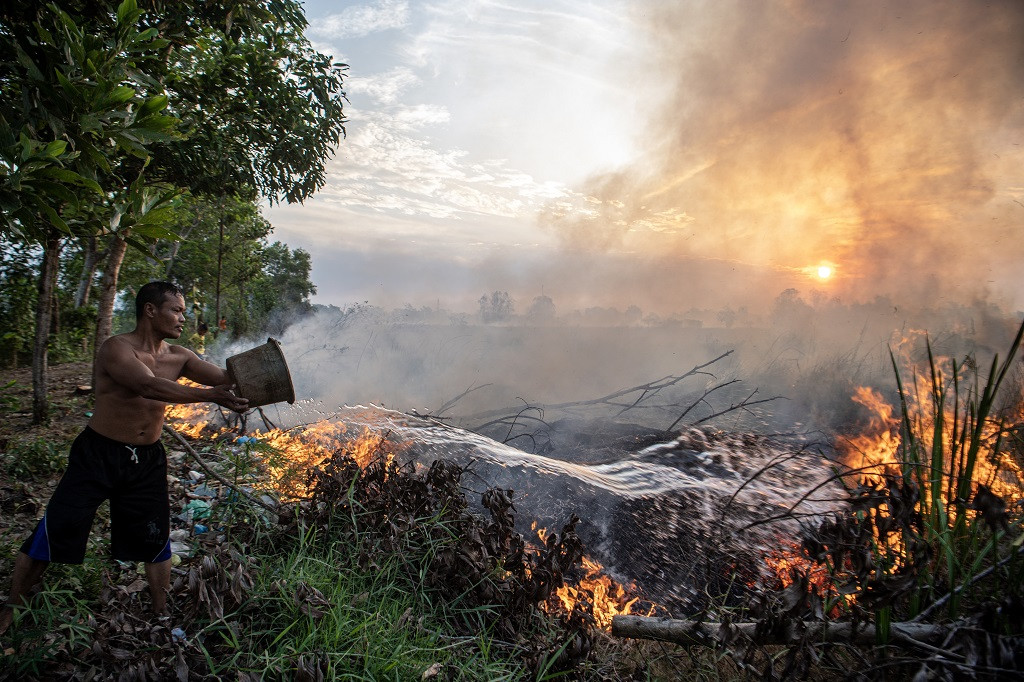 A man throws water in an attempt to douse a wildfire in Pemulutan district, Ogan Ilir regency, South Sumatra, on Sept. 12, 2023.
(Antara/Nova Wahyudi)
A man throws water in an attempt to douse a wildfire in Pemulutan district, Ogan Ilir regency, South Sumatra, on Sept. 12, 2023.
(Antara/Nova Wahyudi)
T
alk of a “super El Niño” developing in 2026 is gaining momentum, with concerns rising that this climate pattern could bring extreme rainfall, heat, drought and destructive flooding around the world.
The signals appear to be in place: The tropical Pacific is warming along the equator, and computer models point toward extreme conditions by the end of the year.
![]() However, forecasting El Niño is not like predicting next week’s weather. Forecasts for El Niño typically are not reliable before late spring, not because scientists don not understand the system, but because we understand its limits.
However, forecasting El Niño is not like predicting next week’s weather. Forecasts for El Niño typically are not reliable before late spring, not because scientists don not understand the system, but because we understand its limits.
As an ocean-atmospheric scientist who studies El Niño, I spend a lot of time thinking about what scientists can forecast confidently, and what remains uncertain. Here is what we know about the current event, what we still do not, and why many regions should begin preparing now, even if a strong, or “super,” El Niño never fully materializes.
The starting point for any El Niño forecast is the heat stored beneath the surface of the eastern equatorial Pacific Ocean. Computer models use data about those conditions to simulate how ocean temperatures will evolve over the coming months, and how they affect weather patterns around the world.
Right now, an exceptionally large reservoir of warm water sits beneath the surface there. In principle, this ocean heat should be a reliable signal of El Niño developing. In practice, what happens next depends heavily on what the atmosphere does.

The warm reservoir was shaped by a burst of wind activity in early 2026. Normally, the Pacific trade winds blow from east to west along the equator, pushing warm water toward Asia and leaving cooler water near South America. But in April, a pair of cyclones straddling the equator caused the wind direction to reverse. This short-lived reversal triggered a downwelling Kelvin wave, a pulse of energy beneath the ocean surface moving eastward along the equator.
That subsurface pulse has now reached the eastern Pacific, helping fuel intense warming off South America. At the ocean surface, this can resemble the early stages of a strong El Niño.
But there is a catch.
For El Niño to develop fully, the ocean and atmosphere need to lock into a feedback loop: Warmer surface waters weaken the trade winds, triggering more downwelling Kelvin waves that push warm water eastward and reinforce the warming. But that loop does not engage automatically. It requires repeated bursts of eastward winds to sustain the process.
Until that feedback loop takes hold, the ocean-atmosphere system is in an unpredictable phase. It might tip into a super El Niño. It might not.
Spring is precisely when forecasts are most uncertain. Impressive early signals can fade if the winds do not cooperate.
There is a further complication: When models detect strong subsurface warming, they can simulate a stronger feedback loop than actually develops.
The result is that models can look too confident, even alarming, despite the system not being locked in. As of mid-May 2026, the wind patterns needed to amplify the warming have not clearly emerged.
We have seen this scenario play out before. In both 2014 and 2017, forecast models were pointing toward strong El Niño conditions by midyear. In both cases, the anticipated wind patterns never fully materialized and El Niño either stayed weak or returned to a neutral state. The early signals were real, but the expected follow-through did not happen.
The current forecasts for 2026-2027 still span a wide range in mid-May, from expecting weak to strong El Niño conditions.
How the winds behave in the coming weeks will determine what develops. If trade winds weaken again at the right moment, it could tip the system into self-sustaining warming, the kind that is hard to stop.
As of mid-May, long-range weather forecasts were not showing strong eastward wind bursts on the horizon that could strengthen El Niño. In fact, quite the opposite was expected for the second half of May: a burst of winds blowing in the opposite direction. A full month without major eastward wind activity would be a meaningful brake on ocean warming.
The Pacific has loaded the dice for El Niño, and the National Oceanic and Atmospheric Administration’s (NOAA) May outlook reflects elevated odds of El Niño developing and potentially strengthening later in the year. By the NOAA’s mid-June update, the picture should be substantially clearer.
The difference between a weak El Niño and an extreme one is not subtle. It reshapes climate patterns across the globe, and with them, real-world risks.
If El Niño intensifies into a strong or “super” event, it can drive drought in the Amazon, fires in Indonesia, flooding in Peru and heavy rainfall in parts of California and southern South America. These effects could materialize by the Northern Hemisphere winter, when El Niño typically peaks.
In some regions, the stakes are immediate.
In India, the monsoon rains, which support agriculture and water supplies for hundreds of millions of people, have historically weakened during strong El Niño events. Even modest shifts in monsoon strength can bring food and water shortages, and harm economies.
At the same time, when El Niño is strong, hurricane activity in the Atlantic is typically suppressed, a rare upside, while the eastern Pacific often becomes more active with storms.
El Niño can even push global temperatures temporarily higher, as changes in cloud cover and the amount of heat the ocean releases alter the planet’s energy balance.
In contrast, a weak El Niño produces far more muted effects. This is why predicting intensity matters.
Because El Niño forecasts deal in probabilities, deciding how to prepare for the seasons ahead should be based on managing risk, not waiting for certainty.
El Niño’s impact does not occur everywhere at once. Some effects emerge quickly. Its impact on the Indian monsoon and Atlantic hurricane activity unfold over the summer and early fall.
Other impacts arrive later, toward the end of the year when El Niño peaks, bringing extreme rainfall to parts of South America between November and January. In Southeast Asia, scorching heat waves often emerge even later, in April of the following year.
In regions like India, decisions about how to respond to El Niño risks cannot wait for more certainty. Communities need to prepare their water infrastructure now in case El Niño means the monsoon season brings too little rain.
Even where forecasts suggest reduced risks, such as a quieter Atlantic hurricane season, it would be a mistake to assume safety. Destructive hurricanes still hit in otherwise quiet years.
---
The writer is an associate research professor in climate modeling at University of Colorado Boulder. This article is republished under a Creative Commons license.