TheJakartaPost
Please Update your browser
Your browser is out of date, and may not be compatible with our website. A list of the most popular web browsers can be found below.
Just click on the icons to get to the download page.

Popular Reads
Top Results
No results found. Please check your search term and try again
Can't find what you're looking for?
View all search resultsPopular Reads
Top Results
No results found. Please check your search term and try again
Can't find what you're looking for?
View all search resultsConfirmation of regional boundaries bolsters IKN development’s legal certainty, governance
Change text size
Gift Premium Articles
to Anyone
Share the best of The Jakarta Post with friends, family, or colleagues. As a subscriber, you can gift 3 to 5 articles each month that anyone can read—no subscription needed!
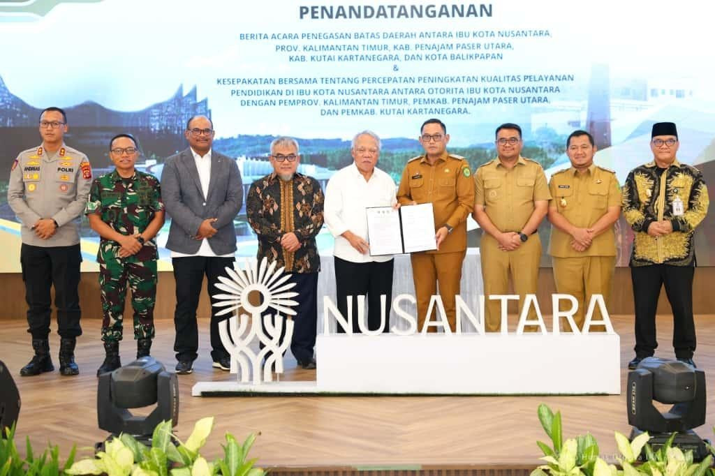 The Nusantara Capital City (IKN) Authority, along with the East Kalimantan provincial administration, the Penajam Paser Utara regency administration, the Kutai Kartanegara regency administration and the Balikpapan city administration, have agreed on the boundaries between the future capital Nusantara and its surrounding administrative areas. The agreement was confirmed through the signing of a memorandum of understanding at the Coordinating Ministry Office 3 in Nusantara’s Central Government District (KIPP) on Oct. 21.
T
he clarity of the boundaries between the future capital Nusantara and its surrounding areas has now been officially agreed upon, marking a significant milestone in strengthening legal certainty, governance and effectiveness of public services in the Nusantara area leading up to its designation as a Special Regional Government (Pemdasus) in 2028.
The boundary agreement was affirmed through the signing of a memorandum of understanding (MoU) among the Nusantara Capital City (IKN) Authority, the East Kalimantan provincial administration, the Penajam Paser Utara regency administration, the Kutai Kartanegara regency administration and the Balikpapan city administration at the Coordinating Ministry Office 3, in Nusantara’s Central Government District (KIPP) on Oct. 21.
Along with clarifying the administrative division between Nusantara and its surrounding areas, the boundary demarcation also serves as a basis for synchronizing spatial planning, infrastructure development and improving the quality of public services.
In addition, an agreement was signed to accelerate improvements in the quality of education services among the IKN Authority and the regional governments in East Kalimantan, underscoring a shared commitment to strengthening human resource development in Nusantara and its surrounding areas through sustainability-based education.
During the occasion, IKN Authority chairman Basuki Hadimuljono expressed his appreciation for the collaboration between the central and regional administrations.
"The IKN Authority expresses our gratitude for the cooperation of all parties, which has resulted in the agreement on these boundaries. We have now begun the second phase of construction and continue to prepare human resources to ensure they are worthy of being part of the future capital Nusantara," he said.
Meanwhile, Home Ministry director general of regional administration development Safrizal ZA emphasized that the confirmation of boundaries was the foundation for effective regional development.
"The confirmation of the boundaries of the future capital city Nusantara is crucial for clear spatial planning and public services. This process was relatively quick, it usually takes two to three years. We will soon submit the Home Ministry regulation," he explained.
Deputy Governor of East Kalimantan Seno Aji called the step a concrete example of synergy between the central and regional administrations.
"The delimitation of these boundaries serves as the legal basis for equitable development and strengthens public services for the community," he said.
Meanwhile, the Geospatial Information Agency’s (BIG) deputy for basic information and geospatial affairs Mohammad Arief Syafi'i added that the step was not just a ceremony, and that the agency would begin creating a 1:5,000 map as directed by President Prabowo Subianto.
The delimitation of these boundaries and educational cooperation emphasizes that the development of Nusantara focuses not only on infrastructure, but also on building a resilient, inclusive and sustainable governance system and human resources. This cross-government synergy provides a strong foundation for the realization of collaborative, transparent and equitable governance in the future Indonesian capital.