TheJakartaPost
Please Update your browser
Your browser is out of date, and may not be compatible with our website. A list of the most popular web browsers can be found below.
Just click on the icons to get to the download page.

Popular Reads
Top Results
No results found. Please check your search term and try again
Can't find what you're looking for?
View all search resultsPopular Reads
Top Results
No results found. Please check your search term and try again
Can't find what you're looking for?
View all search resultsWin-win solution for Indonesia, Vietnam possible
The overlapping claims and the delimitation of maritime boundaries for some countries can lead to negotiation for cooperative management mechanisms in the form of a maritime joint development zone to manage and exploit marine resources offshore temporarily until the maritime delimitation can be reached.
Change text size
Gift Premium Articles
to Anyone
Share the best of The Jakarta Post with friends, family, or colleagues. As a subscriber, you can gift 3 to 5 articles each month that anyone can read—no subscription needed!
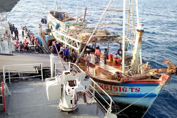
 Indonesian Navy personnel take into custody a fishing vessel with its Vietnamese crew members on board during a security operation in Natuna Islands waters in Riau Islands. War vessel KRI Cut Nyak Dien-375, belonging to the first Fleet Command, apprehended the KG 1916 TS fishing boat and its 15 crew members for allegedly fishing illegally in Indonesian territory. (Courtesy of 1st Fleet Command/-)
O
n the sidelines of the 34th ASEAN Summit in Bangkok in June, President Joko “Jokowi” Widodo held a bilateral meeting with Vietnamese Prime Minister Nguyen Xuan Phuc, during which they expressed commitment to expediting maritime delimitation between the two neighbors.
Several incidents, including the ramming by Vietnamese fisheries resources surveillance ship KN-213 of Indonesian Navy corvette Tjiptadi 381 in the maritime grey area late in April, have overshadowed bilateral relations between the two countries.
Both President Jokowi and PM Nguyen were surely unhappy with the incidents considering the efforts to retain vibrant bilateral relations through the signing of, among other agreements, the Joint Statement for Strengthening the Strategic Partnership in 2018, Plan of Action for the Implementation of the Strategic Partnership (2019-2023) in 2018 and the Joint Communique on Voluntary International Cooperation to Combat Illegal, Unreported and Unregulated (IUU) Fishing to Promote Sustainable Fisheries Governance in 2018.
Fish poaching remains a thorn in the flesh of the Jakarta-Ho Chi Minh relationship. Between 2014 and February 2019, Indonesia sank 294 Vietnamese-flagged fishing vessels for illegal fishing.
Maritime boundary delimitation with Vietnam turns out to be challenging for Indonesia. It took the two parties approximately 25 years to ink the Agreement on the Delimitation of the Continental Shelf Boundary in 2003.
It looked possible for Indonesia to negotiate the continental shelf boundary and Exclusive Economic Zone (EEZ) as a package deal, but the hydrocarbon resources were perceived to be of particular relevance as the seabed area around Natuna Island is close to the continental shelf delimited area and has proven to be oil- and gas-rich. Seabed delimitation was therefore considered more urgent.
The different perceptions in projecting baselines resulted in overlapping claims between Indonesia and Vietnam. Indonesia’s baseline to project its claim over the EEZ “moves forward” from the agreed continental shelf. On the other side, Vietnam claims its projection over the EEZ at the same line as the agreed continental shelf by using straight baselines, in which the conditions to draw are set in Article 7 of the United Nations Convention on the Law of the Sea (UNCLOS).