TheJakartaPost
Please Update your browser
Your browser is out of date, and may not be compatible with our website. A list of the most popular web browsers can be found below.
Just click on the icons to get to the download page.

Popular Reads
Top Results
No results found. Please check your search term and try again
Can't find what you're looking for?
View all search resultsPopular Reads
Top Results
No results found. Please check your search term and try again
Can't find what you're looking for?
View all search resultsDisasters and calls for paradigm shift
Its location in one of the world’s most dangerous regions — known as the Ring of Fire — should have prompted Indonesia to strengthen its preparedness for natural disasters
Change text size
Gift Premium Articles
to Anyone
Share the best of The Jakarta Post with friends, family, or colleagues. As a subscriber, you can gift 3 to 5 articles each month that anyone can read—no subscription needed!

Its location in one of the world’s most dangerous regions — known as the Ring of Fire — should have prompted Indonesia to strengthen its preparedness for natural disasters. However, the nation’s awareness of the danger and readiness to deal with disasters seem lacking, as calamities continue to loom. The Jakarta Post’s Fachrul Sidiq, Novan Iman Santosa and Imanuddin Razak, along with correspondents Panca Nugraha, Rizal Harahap, Ruslan Sangadji and Benny Mawel, take a close look at measures the nation takes in disaster-prone areas.
Last year was one of the deadliest periods for Indonesia, when 2,564 disasters, including earthquakes, tsunamis, floods, land liquefaction and landslides claimed more than 3,300 lives, while more than 1,400 people were reported missing and 21,000 others injured. The National Disaster Mitigation Agency (BNPB) has declared it the year of
disasters.
That trend is showing no signs of abating in 2019, as 438 people have been killed in the first three months of the year, nearly three times as many as in the same period last year, when 152 people lost their lives in disasters, according to BNPB head Lt. Gen. Doni Monardo.
Indonesia is among the world’s most seismically active countries, as it sits on the Pacific Ring of Fire, an arc of volcanoes and fault lines encircling the Pacific Basin, yet the country is more focused on post-disaster efforts rather than preventive measures, which is stipulated in the 2007 law on disaster management.
A lack of funding has frequently been cited as a major problem in the effort to prevent and mitigate disasters. Making matters worse, many Indonesians have yet to be made aware of the threats.
Weak law enforcement against parties and businesses degrading the environment exposes Indonesia to greater risk.
“We need a breakthrough, because the environmental damage has led to unending disasters,” Doni said in a recent exclusive interview.
“Our environmental protection management is still weak, and we should have shown the red card to the textile industry for failing to heed regulations. [The industry] may be the biggest income contributor for the country after palm oil, but look at the damage,” he added.
None of the rivers in West Java are clean nowadays, Doni said, largely due to pollution from industries that fail to apply good waste management practices. He also questioned the allowance for companies to develop factories in areas 500 meters above sea level, which produces pollution that heavily contaminates water in upstream areas.
“The proof is, if you look at the rivers, you’ll not find any surviving fishes,” he said.
The call for preemptive action has never been greater, as Indonesia is soon to welcome the dry season, when forest fires are predicted to hit areas across the archipelago. In previous years, fires have seen millions of people in thousands of villages suffer from a lack of access to clean water.
Doni said it was a compromise for each region to allocate at least 1 percent of its budget to environmental causes.
“There are provinces and cities or regencies that do not have any budget allocation [for the environment]. Not to mention areas near the subduction zones, where earthquakes are bound to happen,” he said, adding that this necessitated a law making the 1 percent budget allocation mandatory.
Many fatalities could be prevented with continuous efforts to raise disaster awareness and mitigate its impacts in times of emergencies, Doni said.
The lack of awareness about the dangers has been proven harmful. During an earthquake that was followed by a tsunami in Palu, Central Sulawesi, last year, many residents did not immediately move to higher ground.
“But in some other regions, including Luwuk Banggai, awareness seems to be better,” Doni said.
Palu and Donggala regency were hit by a 7.4-magnitude earthquake in 2018, while soil liquefaction occurred in Sigi regency.
Barely recovering from the calamities, residents of Sigi have had to face another disaster this year, when a flood hit the area, forcing more than 2,000 residents to evacuate as their homes were inundated.
“Despite all limitations we have, we are more prepared to handle floods,” Central Sulawesi Governor Longki Djanggola told The Jakarta Post last weekend. An emergency status had been declared from April 28 to May 4, he added.
According to Central Sulawesi Disaster Mitigation Agency (BPBD) head Bartholomeus Tandigala, affected residents now knew better what to do when disaster strikes. The evacuation process faced no obstacles as the residents already understood where to go.
Bartholomeus added that residents had been warned of a quake possibly hitting the area as a result of two active faults that stretch from Banggai regency to Banggai Laut regency.
“The Palukoro fault is one of the most active faults,” said Abdullah, an expert from Tadulako University.
Meanwhile, the Peleng fault has the potential to cause a 6.9-magnitude quake, as it moves 1 millimeter per year, according to the Meteorology, Climatology and Geophysics Agency (BMKG).
Banggai Island also faces a tsunami threat, as evident in the past. In December 1858, a tsunami was recorded to have severely damaged villages in the area. In May 2000, an estimated 3 to 6 meter tsunami, triggered by a 7.5-magnitude earthquake, hit Luwuk, Banggai and Peleng, leaving 54 people dead and more than 264 injured.
To anticipate disasters, Banggai Regent Herwin Yatim said cooperation with the local BPBD had been continuously developed to mitigate the impact by preparing evacuation centers, so that “residents will know where to go” when disaster strikes.
In West Nusa Tenggara (NTB), disaster mitigation efforts were upgraded through the installation of 10 seismic intensity meters across Mataram earlier this month, thanks to assistance from the government of Japan, which gave the Indonesian government a total of 100 intensity meters. The tools are able to detect earthquakes and changes caused to the ground.
The head of the geophysics division at the BMKG in NTB, Agus Riyanto, said plans were in place to install more intensity meters across Lombok, an island prone to earthquakes. The agency would also develop three new Shelter Seismograph Broadband, an instrument able to respond to ground motion.
“Efforts to improve disaster literacy have also been carried out. Since the earthquake last year, the BMKG had conducted an awareness campaign, tsunami drills, tabletop exercises and earthquake simulations at schools,” Agus said, adding that the agency would carry out inspections to assess whether buildings in the area had been constructed in accordance with the building code on earthquake-resilience.
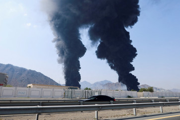
In Riau, forest fires remain the biggest threat, despite mitigation efforts that have reduced their number in the past three years.
“It’s impossible to eradicate forest fires completely considering the size of Riau,” BPBD Riau head Edwar Sanger said.
According to the agency data, 3,029 hectares of land in Riau, spread out across 12 regencies and cities, have been affected by fire since January. The worst-hit area to be hit by fire was Bengkalis regency, where 1,354 ha of land were razed.
Edwar said the eastern coast was the most vulnerable area, mainly because the weather there was hard to predict.
“Forest fires is the most crucial issue in Riau, because they are caused by human behavior. So the first thing we need to do is to warn residents against burning forest to open new land for plantations. However, they are unaware of the danger,” Edwar said.
Apart from forest fires, the area is prone to floods, which can last for two weeks during heavy rains. Despite claiming to have raised the awareness of residents, particularly those living near riverbanks, Edwar said the lack of personnel in the agency posed a challenge.
Only 20 of 70 staff members at the agency were qualified to work on the rapid response team.
“It’s not easy to create qualified staff, since the job requires certain abilities,” he said, adding that 80 personnel should ideally have the capacity to join the fast-response team.
In Papua, disaster threats are dominated by hydrometeorology-related calamities, such as various types of flooding and landslides.
“Seventy-one percent of the disasters in Papua are related to hydrometeorology, another 18 percent are non-natural disasters, such as residential and forest fires, and the remaining 11 percent are social disasters and geology-related disasters,” BPBD Papua head Welliam R. Manderi, told the Post recently.
Welliam expressed concern about insufficient disaster mitigation infrastructure in Papua in view of the province’s vast territory.
“Safe assembly points and evacuation routes, for example, are only available at several villages [that have been set up as pilot projects], while food logistics are only available in a few major regencies, and the number of tsunami buoys is still limited,” he said.
Welliam, however, praised the local people’s increasing disaster awareness, as reflected in their active participation in disaster response drills at workplaces and residential complexes.