TheJakartaPost
Please Update your browser
Your browser is out of date, and may not be compatible with our website. A list of the most popular web browsers can be found below.
Just click on the icons to get to the download page.

Popular Reads
Top Results
No results found. Please check your search term and try again
Can't find what you're looking for?
View all search resultsPopular Reads
Top Results
No results found. Please check your search term and try again
Can't find what you're looking for?
View all search resultsEl Niño returns, with moderate risk in Indonesia
Change text size
Gift Premium Articles
to Anyone
Share the best of The Jakarta Post with friends, family, or colleagues. As a subscriber, you can gift 3 to 5 articles each month that anyone can read—no subscription needed!
T
he hotter El Niño climate pattern is back after three years and while it threatens to bring with it extreme weather events, several meteorological agencies have suggested this week that Indonesia is likely to be at relatively moderate risk from such events, due to variables ranging from sunspots to sea surface temperatures (SSTs) in the Indian Ocean.
The Climate Prediction Center (CPC) of the United States’ National Oceanic and Atmospheric Administration (NOAA) on Thursday issued an El Niño advisory on the weather phenomenon’s arrival.
El Niño is marked by above-average SST in the central and eastern tropical regions of the Pacific Ocean.
“Depending on its strength, El Niño can cause a range of impacts, such as increasing the risk of heavy rainfall and droughts in certain locations around the world,” Michelle L’Heureux, a CPC climate scientist, said in a statement on Thursday.
“Climate change can exacerbate or mitigate certain impacts related to El Niño. For example, El Niño could lead to new records for temperatures, particularly in areas that already experience above-average temperatures during El Niño,” L'Heureux added.
NOAA forecast that El Niño’s influence on US regions would be weak during the summer and more pronounced starting in the late fall through spring. By its peak in winter from November to January, there was “an 84 percent chance of exceeding moderate strength”, the advisory said, and a 56 percent chance of a strong El Niño.
Meanwhile, Australia’s Bureau of Meteorology activated its El Niño Alert on Tuesday, forecasting a 70 percent chance of the weather phenomenon developing in 2023, which it said was “roughly three times the normal chance”.
The bureau also noted that the alert’s activation was “not a guarantee that El Niño will occur, it is an indication that most of the typical precursors of an event are in place”.
In 2016, the last time El Niño formed, the world saw its hottest year on record. Combined with warming from climate change, global temperatures could reach new highs this year or next.
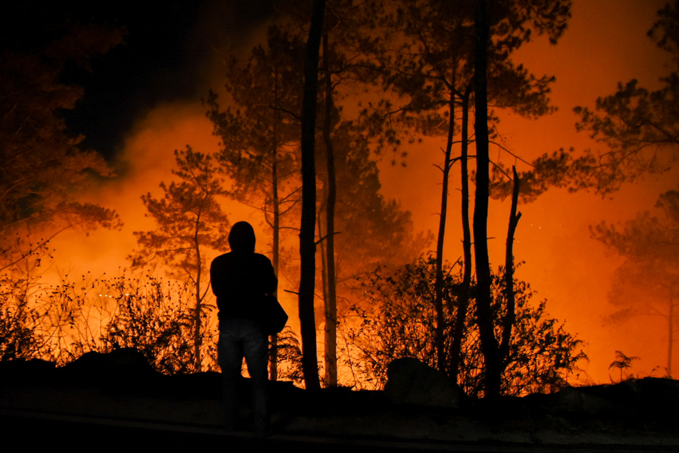
Early signs of hot, dry weather caused by El Niño are threatening food producers across Asia, and it is feared it could impact palm oil and rice production in Indonesia, Malaysia and Thailand.
However, the phenomenon does not uniformly affect countries in the region, and many other variables are at play.
Indonesia’s Meteorology, Climatology and Geophysics Agency (BMKG) forecast an 80 percent probability that El Niño had started this month in the archipelago, albeit at low to moderate strength.
BMKG head Dwikorita Karnawati said the agency’s observations of sea surface temperatures in the Pacific Ocean indicated that La Niña, the cool counterpart to El Niño, had ended in February.
In addition to El Niño, the BMKG also forecast that the Indian Ocean Dipole (IOD), or irregular fluctuations in SSTs, had entered a positive phase in June. This meant warmer waters in the western Indian Ocean and lower temperatures in the eastern part, which tended to cause drier weather over adjacent landmasses, including Indonesia.
“The combination of El Niño and the positive IOD predicted for the second semester of 2023, there will be less precipitation across most of Indonesia during the 2023 dry season,” Dwikorita said in a statement released on Wednesday.
Indonesia must therefore be alert to the potential impacts of El Niño, such as droughts, hot spots and wildfires, she added.
Dwikorita also said some preparation would need to be made in anticipation of the hotter weather pattern, including maintaining water levels at dams and reservoirs by storing rainwater ahead of the dry season, as well as mitigation efforts in regions prone to wildfires.
Moderate outlook
Local climate scientists say that El Niño’s impacts on Indonesia this year will depend on several variables, from solar activity to a warming Indian Ocean.
Edvin Aldrian, a meteorology and climatology professor at the National Research and Innovation Agency (BRIN), said El Niño would likely be of low to moderate intensity this year, as a strong El Niño tended to occur during a solar maximum, or the peak activity of the sun’s cycle of 11 years when many sunspots appeared.
“El Niño this time will not be too severe,” Edvin told The Jakarta Post on Friday.
A 2021 paper published in the journal Earth and Space Science linked so-called terminator events, or the end of the solar magnetic cycle mirrored by fluctuations in the number of sunspots, with the shift from El Niño to La Niña. The sixth terminator event and the start of the new cycle occurred in 2020, coinciding with La Niña’s arrival.
Eddy Hermawan, a research professor at BRIN’s Center for Climate and Atmosphere, concurred separately that weather in Indonesia was affected not only by El Niño, but also the IOD.
“We should not only focus on El Niño, as its intensity will be moderated by the sea surface temperature of the Indian Ocean,” Eddy told the Post on Friday.
He added that although El Niño and the IOD’s positive phase had both been detected, they would each peak around late August or early September before resuming their normal phases.