TheJakartaPost
Please Update your browser
Your browser is out of date, and may not be compatible with our website. A list of the most popular web browsers can be found below.
Just click on the icons to get to the download page.

Popular Reads
Top Results
No results found. Please check your search term and try again
Can't find what you're looking for?
View all search resultsPopular Reads
Top Results
No results found. Please check your search term and try again
Can't find what you're looking for?
View all search resultsOver 4,600 residents evacuated after Ili Lewotolok eruption
The eruption lasted around 10 minutes and brought down volcanic material as big as coconuts.
Change text size
Gift Premium Articles
to Anyone
Share the best of The Jakarta Post with friends, family, or colleagues. As a subscriber, you can gift 3 to 5 articles each month that anyone can read—no subscription needed!
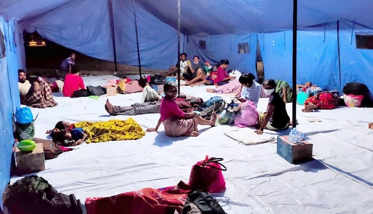 Evacuees forced to leave their homes after the eruption of Mount Ili Lewolotok in Lembata, East Nusa Tenggara (NTT), rest in a makeshift shelter on Nov. 29. (AFP/Joy Christian)
T
he eruption of Mount Ili Lewotolok in Lembata regency, East Nusa Tenggara, on Sunday morning has forced 4,628 residents out of their homes, according to the Lembata Disaster Mitigation Agency (BPBD).
The volcano spewed a column of volcanic ash and smoke 4,000 meters into the air at 9:45 a.m. local time on Sunday. The eruption lasted around 10 minutes and brought down volcanic material as big as coconuts, said the Volcanology and Geological Hazard Mitigation Center (PVMBG).
Ili Lewotolok’s alert status has been raised to siaga (watch), or level three of the country's four-tiered alert system, from level two, waspada (advisory), at 1 p.m. on Sunday.
The 4,628 evacuees are taking refuge at seven shelters across the regency as of Monday, including at the old regent’s office complex, according to the Lembata BPBD.
No injuries or damages have been reported.
The PVMBG has warned residents living on the slopes of Ili Lewotolok of potential cold lava flows, especially during heavy rain. Residents, visitors and climbers have been advised to remain outside a 4-kilometer radius from the crater.
Read also: Reporting platform will boost disaster response: Observers
The National Disaster Mitigation Agency (BNPB) said local authorities were doing their best to ensure everyone at the shelters followed COVID-19 health rules to reduce the risks of COVID-19 transmission among evacuees.
“However, the local disaster agency will need more personal protective equipment like face masks,” BNPB spokesman Raditya Jati said in a statement on Monday.
Indonesia has seen several volcanic eruptions throughout 2020. Mount Anak Krakatau in Lampung and Mount Semeru in East Java erupted on the same day in April.
Mount Sinabung in Karo regency, North Sumatra, erupted in August after being inactive for more than a year, spewing ash and smoke thousands of meters into the air several times.
Read also: Mount Merapi spews lava amid increasing volcanic activity
Earlier this month, Mount Merapi in Magelang, Central Java, one of the most active volcanoes in Indonesia, ejected lava around 3,000 m into the air, forcing hundreds of residents living around the mountain to evacuate the area.
Indonesia sits on the Pacific Ring of Fire, an arc of volcanoes and fault lines encircling the Pacific Basin, making it one of the world’s most seismically active regions prone to tectonic and volcanic eruptions, earthquakes and tsunamis.
In addition, man-made disasters such as urban flooding persist in many regions.
Last year, Indonesia recorded 9,384 natural disasters, including earthquakes, tsunamis, floods, land liquefaction and landslides, which left 684 people dead. This year, as of Sept. 3, the BNPB has recorded 1,944 disasters that killed 272 people. Despite having frequent disasters, emergency preparedness among the public is still lacking, experts have said.