TheJakartaPost
Please Update your browser
Your browser is out of date, and may not be compatible with our website. A list of the most popular web browsers can be found below.
Just click on the icons to get to the download page.

Popular Reads
Top Results
No results found. Please check your search term and try again
Can't find what you're looking for?
View all search resultsPopular Reads
Top Results
No results found. Please check your search term and try again
Can't find what you're looking for?
View all search resultsWhat scientists know about a potential 'super' El Nino
The fast-warming tropical Pacific is pointing to a major event but a crucial weakening of trade winds -- capable of turbocharging or throttling the phenomenon -- has yet to materialise.
Change text size
Gift Premium Articles
to Anyone
Share the best of The Jakarta Post with friends, family, or colleagues. As a subscriber, you can gift 3 to 5 articles each month that anyone can read—no subscription needed!
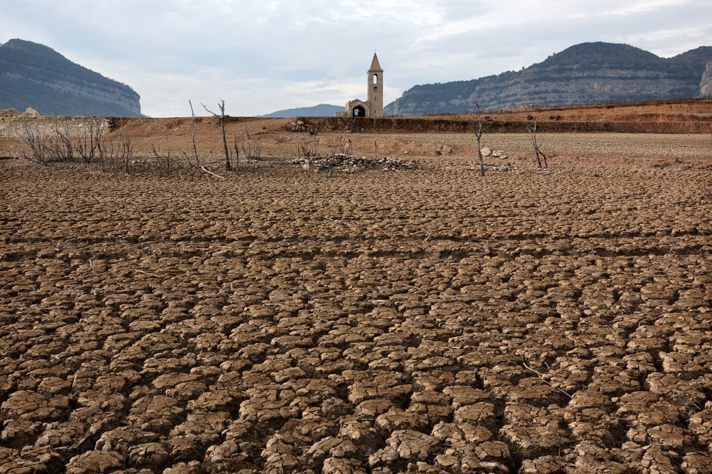 This photograph taken on January 15, 2024 shows the dry soil next to the low water-level reservoir of Sau with in background Sant Roma de Sau church, in the province of Girona in Catalonia. Catalonia struggles with historic drought for three years, with some residents already experiencing water restrictions in their daily life. (AFP/Lluis Gene)
F
orecasters say a potentially "super" El Nino is rapidly taking shape in the Pacific -- but whether it evolves into a history-making event could hinge on fickle winds and other volatile atmospheric shifts.
The fast-warming tropical Pacific is pointing to a major event but a crucial weakening of trade winds -- capable of turbocharging or throttling the phenomenon -- has yet to materialise.
Scientists say these interactions are notoriously complex and difficult to predict -- making it too early to confidently forecast how powerful this El Nino could become.
Flashing red
The US National Oceanic and Atmospheric Administration (NOAA) says there is about an 80 percent chance of El Nino developing by July.
Sea temperatures in key El Nino zones of the equatorial Pacific are rapidly rising, and an enormous pool of abnormally warm water is massing beneath the surface.
Several leading weather services are predicting Pacific sea temperatures could surge 2.5C or more above average later this year -- exceptionally high projections.
Just three events -- 1982/83, 1997/98 and 2015/16 -- have breached 2C since the first major El Nino recorded in the modern era in 1877/78.
Adam Scaife, head of long-range prediction at the UK Met Office, said this El Nino could be the strongest in decades or "even be of record strength".
"There's definitely something coming. We're very confident about that, and it looks like it will be a big event," he told AFP.
Wily winds
NOAA forecasts a one-in-three chance this episode will hit 2C or above -- crossing into what is dubbed "super El Nino" territory.
But key pieces of the puzzle had yet to fall into place, said Michelle L'Heureux, NOAA's El Nino-Southern Oscillation lead.
El Ninos build strength as the ocean and atmosphere increasingly "couple" over the summer months, shifting air pressure, cloud patterns and winds.
This feedback loop can turn a modest El Nino into a blockbuster event, supercharging heat and triggering chaotic weather worldwide.
A hallmark of the strongest El Ninos is the weakening of trade winds that blow east to west across the equator.
But those winds are unpredictable and can strengthen unexpectedly, said L'Heureux.
"When that happens, it pauses the growth of El Nino or even reverses it," she told AFP.
"Ultimately the strength of this event will be likely influenced by these details, like the low-level winds, which we cannot predict many months in advance."
Heat incoming
El Nino tends to peak around December but ocean heat releases slowly and can drive up global temperatures the following years.
Many record-hot years -- including 1998, 2010, 2016, 2023 and 2024 -- followed major El Nino events or developed alongside them.
Climate scientists interviewed by AFP said global heat records could fall in 2026 -- but 2027 was the year to watch.
There "could easily be a new record level of global warmth in 2027" if an extreme El Nino takes shape this year, said Scaife.
It remains unclear whether Earth's warming is influencing El Nino intensity. The last event in 2023/24 was weaker than episodes in 1982/83 and 1997/98, making any trend hard to pin down.
Scientists stress that stronger El Ninos raise the odds of more severe impacts -- but do not guarantee them.
Yet even a weaker event now unfolds in a world transformed by climate change, with extra heat and moisture loading an already feverish atmosphere and oceans.
That means El Nino's impacts could become more extreme even if the phenomenon itself is not growing stronger.
"The impacts of this El Nino -- on things like rainfall and of course temperature -- are riding on top of climate change, and could well be larger than anything we've seen in the past," said Scaife.
Every El Nino is different, but major events often follow familiar patterns: drought across parts of the Amazon, Indonesia and Australia, disrupted Indian monsoons, and shifting rainfall throughout the tropics.
But climate change has shifted the baseline so dramatically that "history is a poorer guide for seasonal predictions," climatologist Felicity Gamble at Australia's Bureau of Meteorology told AFP.
"What happened during an El Nino event 20 years ago is probably quite different to how it might manifest these days."
Forecasts are also complicated by climate-driven ocean warming, which makes it easier to trigger El Nino conditions and harder to distinguish La Nina, its opposite cooling phase, against a hotter backdrop, Gamble said.
The Bureau of Meteorology and NOAA have started filtering out background warming to improve forecast accuracy. Other weather agencies are adopting similar adjusted benchmarks.
Even still, Australia is predicting El Nino could reach 2.8C -- potentially a history-making event.