TheJakartaPost
Please Update your browser
Your browser is out of date, and may not be compatible with our website. A list of the most popular web browsers can be found below.
Just click on the icons to get to the download page.

Popular Reads
Top Results
No results found. Please check your search term and try again
Can't find what you're looking for?
View all search resultsPopular Reads
Top Results
No results found. Please check your search term and try again
Can't find what you're looking for?
View all search resultsA one true map, not a 'no-one's map'
Weak forest and land governance is often influenced by inaccurate, incomplete and outdated reference maps.
Change text size
Gift Premium Articles
to Anyone
Share the best of The Jakarta Post with friends, family, or colleagues. As a subscriber, you can gift 3 to 5 articles each month that anyone can read—no subscription needed!
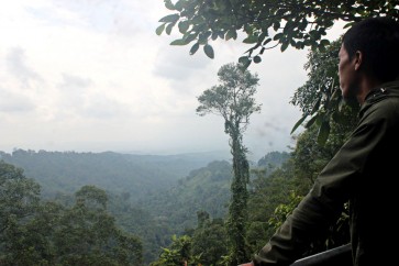
 The lungs of the Earth – Thick rainforests covering the Gunung Gede Pangrango National Park (TNGGP) in West Java offers natural richness visitors can learn. (JP/Theresia Sufa)
I
f we look back and think about why fires are such a regular occurrence in Indonesia, we should know that the problem lies in how we manage our forests and lands. Weak forest and land governance is often influenced by inaccurate, incomplete and outdated reference maps, causing issues such as slow spatial planning process, the overlapping of concessions and licenses, as well as growing conflicts involving local communities.
In response to this persisting issue, President Joko “Jokowi” Widodo, through Presidential Regulation No. 9/2016, issued a breakthrough initiative called the One Map policy to systematically and fundamentally reorganize Indonesia’s forest and land in an accountable manner.
The One Map policy calls for a synchronization of thematic maps from various sectors, including land-based concession maps such as mining, plantation and forestry.
The synchronization of maps is deemed effective to ensure that our natural resources are not overly exploited and are used in an accountable manner.
Research by the Indonesia Corruption Watch (ICW) showed that state losses from missing potential non-tax revenue in forestry amounted to Rp 169.7 trillion (US$12.8 million) in 2004 to 2007 alone.
On top of economic losses, weak accountability in Indonesia’s land management has also led to forest and land fires, which have undermined people’s welfare, health and caused additional economic loss of Rp 220 trillion.
Now, what does the synchronization entail? In the context of land-based concession maps, all concessions polygons were placed on top of the Geospatial Information Agency’s earth map, which serves as a reference map.